

Recent NOAA review of the event
This entry is fairly lengthy. The initial write-up here was written for Stormtrack Magazine and/or the TESSA Weather Bulletin. My slide photos are included in the write-up, and digital stills of the tornado are at the end of the write-up. After that is a section called “notes and thoughts”, which I have written some ten years after the event. And, finally, at the bottom are numerous links to other web sites regarding the Spencer tornado. On Roger Edwards’ site are additional photo galleries of the tornado, including some by my other chase partners on this day—-Martin Lisius, Keith Brown, and Cheryl Chang. I highly recommend the chase accounts by Roger, Martin, Charles Doswell, and Alan Moller which are linked from Roger’s web site. At the bottom is a link to video clips of the tornado.
**************
Following three great consecutive supercell days in western Kansas, the chase vacation for Keith, Cheryl, and myself slowed considerably after May 24th. We toured the minor damage (from a weak tornado on the 22nd) north of Joes, Colorado, on the 25th, watched a moisture-starved storm struggle near Brush, Colorado, on the 26th, and had some fun with a pretty storm near Chappell, Nebraska, on the 28th. On May 29th we were at a truck stop at Big Springs, Nebraska, all afternoon. We waited with Dave Gold and his group for a worthy storm to go after. Dave’s laptop showed a wimpy thing out around Scottsbluff, but we blew it off and called it a bust. Meanwhile, Martin Lisius was making his way this day towards the High Plains from Arlington, Texas. He and hundreds of other chasers were suffering through the great 1998 Texas/Oklahoma tornado drought. Martin was practically desperate to see a decent storm—a storm in a smoke-free environment. He joined us at sunset, and we watched some lightning way off to the north after dark. We found motel rooms in Ogallala, knowing that the next day should be more entertaining.
Martin was banging on the door at 7 a.m. “Let’s get moving! We need to drive to northwest Iowa!” I thought, “let’s see, how can I tell him nicely that I don’t want to go to northwest Iowa?” Then I reconsidered. It was Keith’s last day to chase, Cheryl was going back to Calgary in a few days, and Martin would kill me if I flaked. “Okay, Martin, we’ll be ready in a jiffy!”
Chasers had good reason to be optimistic on this Saturday. The Day One Convective Outlook from SPC, issued at 10Z, had a moderate risk for a “large part of Iowa and southern Minnesota.” A slight risk of severe weather reached as far west as Beatrice to Pierre to Bismarck, approximately. The outlook read: “Parameters appear to be coming together for an active severe weather day across the upper Mississippi Valley into the Great Lakes region. A well-defined shortwave trough (lifting northeastward over northern Utah) is expected to move rapidly over the Rockies and into the Plains, and to phase with another strong shortwave trough dropping southeastward from central Canada into the northern Plains/upper Mississippi Valley. An area of low pressure was located over the High Plains of extreme northeastern Wyoming, and a warm front extended eastward through South Dakota into northern Illinois. This surface low will move quickly eastward through the northern Plains and deepen, and increasing southerly low-level flow will begin to bring moisture northward into the upper Mississippi Valley and Great Lakes. As the upper trough becomes better organized across the northern Plains, a strong westerly mid-level jet (60-75 knots at 500 mb) is forecast to develop from the central Plains into the Great Lakes. At the same time, southerly 850 mb winds increase to 30-50 knots from southeastern Nebraska into southern Minnesota by early afternoon. The resulting wind profiles would show strong veering in the low levels, with speeds increasing to 75 knots in the mid levels. This type of wind profile suggests a potential for supercell formation.” The outlook went on to mention the possibility of isolated tornadoes, and an evolution from scattered supercells into a squall line after 03Z, with bow echo and derecho events in Wisconsin and Michigan overnight. The early morning discussion out of Omaha noted, a “rather distinct boundary from Rapid City to Ainsworth and east into northwestern Iowa,” and “rather warm 700 mb temps reflecting current cap over much of southern two-thirds of Nebraska and Kansas.”
Given these outlooks and other NWS discussions and forecasts, it was obvious that we had to be a lot farther east and a little north. Martin and I agreed that it would be nice to be in Storm Lake, Iowa, by mid-afternoon. We would play the warm front and surface low, and fine-tune our forecast as the day progressed, naturally.
We made good time along Interstate 80, and at noon we stopped at Bosselman’s in Grand Island for lunch and weather data. The latest data and discussions indicated that morning convection was moving east into northwest Iowa (with large hail near Storm Lake!). A severe thunderstorm watch for southeast South Dakota and northeast Nebraska was allowed to expire at 10:30 a.m. Recent severe weather outlooks out of Aberdeen, Sioux Falls, Omaha and Des Moines all mentioned the possibility of tornadoes later this Saturday. An updated (15Z) Day One convective outlook by SPC continued to highlight the moderate risk area (east of a line from Des Moines to Sioux Falls to Redwood Falls), saying “thunderstorms should redevelop by late afternoon along the warm front over portions of northern Iowa and southern Minnesota.” Capes in northern Iowa would be near 4000 J/kg, BRN shear values would be near 100 m2/s2, and “activity will rapidly become supercellular and potentially tornadic.” Well, that sounds pretty good! Let’s get a move on!
(At the bottom of the 15Z outlook, for the eastern Montana/Dakotas region, a brief paragraph read: “Shortwave trough is expected to move across the area this afternoon. Steep lapse rates coupled with residual moisture will allow for moderate instability. Cold temperatures aloft suggest a threat for large hail with storms that form in association with the upper feature.”)
Just prior to leaving the Bosselman’s, a lady came up to me and asked me to come over to say “hello” to her husband, a storm chaser from Pennsylvania. The lady was Nancy, and her husband was Brian Morganti. I had e-mailed Brian once or twice, and finally got to meet him in person! We both agreed that extreme northwest Iowa looked to be the spot to stake out, and we wished each other good luck.
A horrendous layer of thick cirrus was overhead, covering most of Nebraska. The sun was only dimly visible at times: the cap was not going to break anywhere near here today. Keith digested all of the data that Martin had downloaded as we progressed eastward on I-80. The 11 a.m. severe weather outlook out of Omaha stated that “low pressure over western South Dakota will move east-southeast to northeast Nebraska by early this evening…and a trailing dry line extending south from the low through western Kansas will move east into eastern Nebraska by early this evening.” Observations at noon showed low-70s dew points at Lincoln, Omaha, and Norfolk, and upper 60s dew points at Yankton, O’Neill, and Valentine, and even way out west at North Platte and Imperial! Where is that dry line?! The noon wind field was rather unorganized, and did not define a clear-cut target area. Why did Lincoln and Valentine have southwest winds? Why were winds at Broken Bow, Kearney, and Ainsworth so weak? Yankton and Offutt AFB had nice southeasterlies, and Norfolk and Sioux City winds were east-southeasterly. Alliance had strong and dry west-northwest winds, so the dry line was way out west in the Panhandle. The morning convection had disturbed the surface pattern a bit, but there should be some lingering boundaries for any late-day storms. Lowest pressure readings at noon were at Pierre and Mitchell, about 1001.7 mb, but the gradients across South Dakota and Nebraska were pathetic: from 1003.5 mb at Sioux Falls to 1002.8 mb at Rapid City; from 1004.9 mb at Offutt (near Omaha) to 1004.0 mb at Scottsbluff. It was still early, though.
At York, Nebraska, Martin exited the Interstate, and Cheryl and I pulled up alongside his Explorer. Martin and Keith were inclined to head north. There was much less high-cloud garbage to the north, the cap was weaker, the warm front was up there, AND the developing surface low-pressure area was forecast to approach extreme northeast Nebraska. I thought that it might be better to stay on the Interstates (we could head north on I-29 from Omaha), but the meteorology was sound, and I had no problem with the proposal to go north now. Moderate risk in Iowa? What moderate risk?! We headed north out of York on U.S. 81 to be closer to the warm front; to get in front of the surface low; to get out from under the high clouds.
We gassed up at Randolph (north of Norfolk), and around 5:30 p.m. we were on a hilltop near Willis, Nebraska. A few, thin, high clouds and a few, small and flat cumulus were visible in the milky sky. Today looked like a major “Bustola Capola,” a melancholy Keith muttered. We were near a weak convergence area, though, where weak southwest winds were bumped up against weak southeast winds. Whoop-de-do. The dew point was around 72F, but our sweat glands were bubbling more than the clouds. What should we do now?

When in doubt, get more data! Martin called Jason Jordan to see if there were any clouds around which were not convectively challenged. I scanned the AM dial for lightning static and any storm information. Keith had his ear to the NOAA wx-radio. Our chase prospects appeared quite bleak, especially when the Siouxland folks predicted a chance of storms beginning after 10 p.m. Our attention turned to the northwest. Was there another state north of Nebraska? Did it have roads? Were they paved? Were they
snow-covered? Did supercells ever develop in this land where few chasers tread? Thanks to Jason and an AM radio station, we learned that some storms were near Chamberlain and Huron. Ouch. If these move southeast, we thought, and if we head north on I-29 and then west on I-90, and they hold together, then maybe we can catch them before dark. And maybe monkeys will fly out of my you-know-what. Oh well. We should go for it. It’s stupid to drive 400 miles and to give up before the daylight is gone. But if anyone had told me Saturday morning that I would have to drive to southeast South Dakota to see storms, I would have retorted: “Forget that noise.”

Between Sioux City and Sioux Falls our spirits increased. A tornado watch covered northeast and east-central South Dakota, and a warning was issued for Hand County! (And we did our Spicoli imitations.) We took full advantage of the Interstates, and continued to Sioux Falls and then westward on I-90. I found an excellent AM radio station, 1390 in Madison (with Kory Hartman at the microphone!), which was updating warnings quickly and even broadcasting details as to the radar picture, warning or no warning. New warnings were issued for counties getting ever-closer: Beadle, Sanborn, Miner. AM 1390 reported new development in Davison County, near Mitchell. That was dead ahead! We could see an anvil already from this new cell, and it exhibited several scallops, indicating several strong updraft pulses. As we neared U.S. 81, Martin and I convened and elected to exit soon, as the storm was closing in at 30 mph. It was close to 8 p.m., and sunset was still a ways off (thank God we were so close to the North Pole). Did this chase still stand a chance? It looked like we had a tail-end-Charlie storm, and the Hand County storm had had a Doppler-indicated tornado warning earlier. If that cell could be tornadic, certainly this Mitchell storm could be, too. I thought that our luck was bordering on the good side again! Besides, we had Cheryl with us.
Our two-vehicle caravan exited at U.S. 81, and we stopped just north of Salem at about 8:10 p.m. To our west was a scrawny little storm, but lightning was very active in an anvil above it. What’s up with this?! A tornado warning was issued for northern Davison and northern Hanson counties, to our west-northwest. Apparently there was something special in the air behind this scrawny updraft. Soon a report came in of a tornado on the ground north of Farmer, moving east. Farmer was 15 miles west! We couldn’t see diddly squat, though. We headed north a mile or two —- dumb move — too much rain — back south to Salem. We went west on Highway 38 and passed a bunch of golfers as light rain fell and lightning flashed. “Potential statistics,” I said.


About four miles west of Salem we cleared the rain and the obnoxious condensation of the intervening mini-cell. The sky opened and an area of daylight hugged the ground to the west-northwest: lots of shallow daylight; a nice, yellow and peach-colored band along the horizon, except for one fuzzy and dark-ish area. A couple of north-south tree lines were now in the way. I thought to myself: “hmmm…radio-reported tornado on ground…..big dark fuzzy thing blocking beautiful sunset sky below dark storm base….big dark fuzzy patch right where tornado report said tornado was…..” Rocket-scientist Reid then said to Cheryl: “I think we’re going to see a tornado right after we get past these trees.”
And so it came to be.
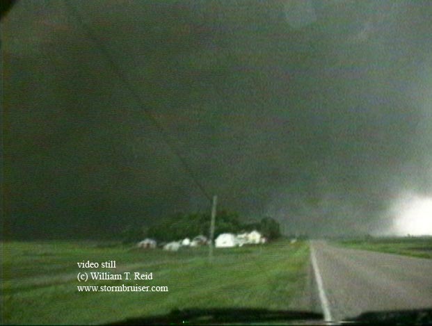
We became wide-eyed (and probably wide-mouthed, too) as a towering, ragged, rotating, supercell cylinder came into view. Below it was a fully-developed truncated cone-tornado: a sugar cone with the bottom half chopped off. WOW!!! It was HUGE! I continued west a mile at most and stopped a tad north of Highway 38, along the paved north-south road four miles east of Spencer (and six miles west of Salem). I could have driven much closer to the tornado, but I wanted to make sure that I got some quality video and slides with the good contrast. Martin and Keith, who followed me out of Salem, stopped short of our location by about 1/8 of a mile along Highway 38. What a magnificent storm! Rookie storm chaser Cheryl was dumbfounded! It’s not supposed to be this good the first time out! I was practically a nervous wreck as I attended to the video and still camera. My gosh—what luck! A monster tornado is moving our way and it is beautifully backlit! It was 8:32 p.m. Our winds were east-southeast at about 20 mph, and a few small hailstones fell. The tornado was not that close yet, about six miles away maybe, but it was moving east at 35 mph (at least according to the earlier report). It was so big that I knew it would last for a while. I thought that it might pass just to our north.


This tornado behaved like an angry, caged animal. It was throwing dust out and pulling dust in. It was wrapping condensation curtains and it was unwrapping condensation curtains. It threw out fingers and spokes and had funnel motion that was unreal! Even though it was still a bit distant, it was clearly a picture of extreme agitation! The tornado continued to approach our location: for several minutes I never had to adjust the camcorder to the right or left. Now the leading edge of the rotating updraft began to loom right overhead, and my still-shot shutter speeds increased from 1/60 sec to 1/15 sec.
At 8:38 p.m. the tornado hit Spencer. A couple of power flashes were caught on my video, but I was unaware that a town was being demolished, and that human lives were ending.


The tornado continued to approach us. It was not going to pass just to our north. It hid itself in a tight robe of condensation, but then reappeared completely uncloaked! It was still a raging monster, and it was less than three miles away to our west. Lightning flashed much too close to us, and thunder crashed within a couple of seconds. I told Cheryl to get in the car, I unlatched the camcorder and handed it to Cheryl, and I nervously grabbed the tripod and threw it into the back of the vehicle. I slammed the rear hatch and jumped into the driver’s seat. Whew —– a strong-to-violent-class tornado was just down the road, but I felt a LOT safer.


It was time for escape maneuvers. The tornado was moving to the east- southeast, and was crossing Highway 38. It was due west, a little less than two miles away, and its diameter was increasing. I drove south towards Interstate 90. (I don’t know why, but I did not even consider going any other direction. I guess I figured that if the tornado had a southerly component, then we needed to go south to be in front of it, and the Interstate was just a few miles south in case we needed a fast escape route.) Cheryl pointed the fully-zoomed-OUT camcorder out her window, and the circulation practically filled the entire picture frame soon after crossing Route 38. I had to quickly get farther south and east. While doing so the tornado weakened, but it continued to incorporate a huge amount of dust and dirt. It looked more like a nasty Kansas storm during the Dust Bowl than a tornado, and it seemed to be beneath an increasingly outflow-dominant base. Another supercell was in the works to our southwest, and our tornadic storm was being consumed by a fast-moving squall line. We bailed east on Interstate 90, south on U.S. 81, and east to Canistota. The sirens were wailing away in Canistota, with storm core and severe outflow to its northwest ready to converge with a vertical tower to the southwest. My stay in Canistota was a short one. I blasted south and then east (on Highway 42) to avoid the ugly jaws. It was getting dark, and I wanted to be as far away from this double-headed monster as I could. New tornado warnings were issued for towns just behind us, and I just held on tight and flew eastward against the strong inflow.
We rode out a core in a motel parking lot in Sioux Falls and I called Martin and Keith. They were south of Sioux Falls, out of harm’s way, and just as elated as Cheryl and I were! What a rush! In close to nothing-flat, our nothing day had turned into a chaser’s dream between Salem and Spencer, South Dakota! I quoted Mark Twain at the end of my Last Chance tornado account (Fall, 1993, Weather Bulletin) and I’ll quote him again here: “Luck is the residue of design.” Martin, Keith, Cheryl and I were very fortunate to see what we saw, but our accomplishments also required a lot of intuition, a lot of chase expertise and a solid meteorological background, and a lot of preparation and perseverance. A storm chaser must make his own good luck. And, apparently, it doesn’t hurt to have Cheryl along for the ride, either.
Cheryl and I stepped into the motel and found the hallway and lobby filled with folks, many of whom were quite distressed. We learned that Spencer had been wiped out and that several people had died. It was a scary evening for many South Dakotans, and, for those left alive in Spencer, our storm-chasing exploits meant nothing.

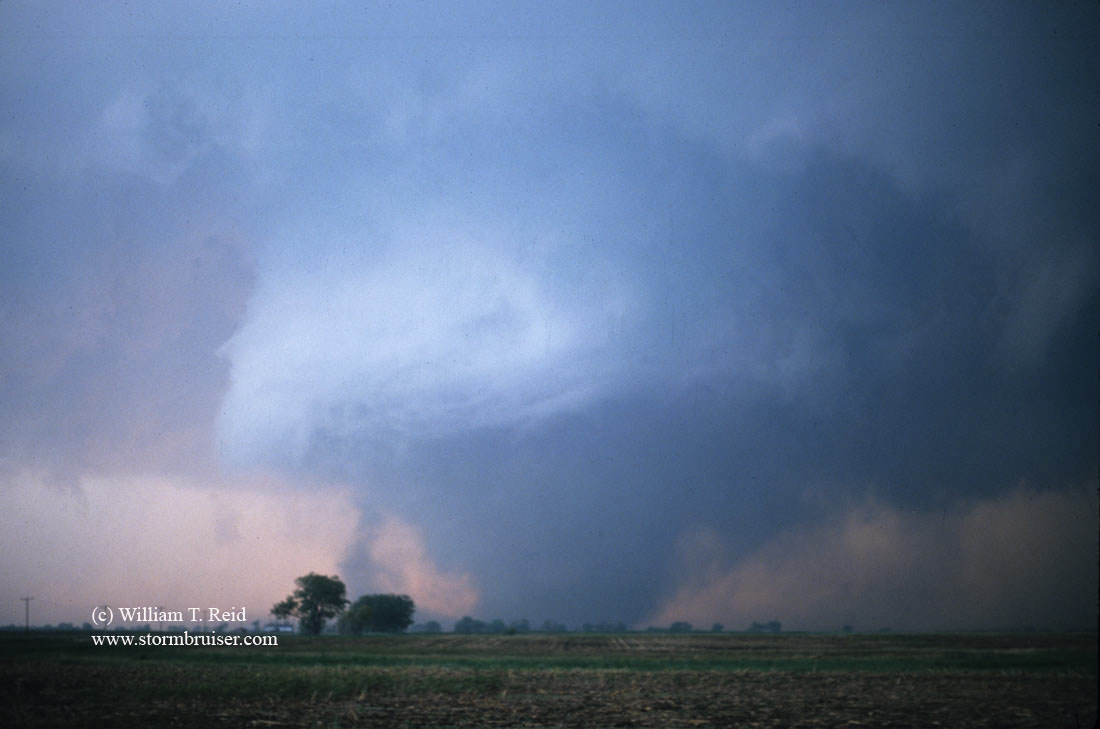
Photo at left of the Spencer, SD, supercell at sunset, looking north…courtesy of Brian Morganti
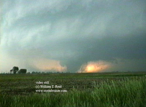
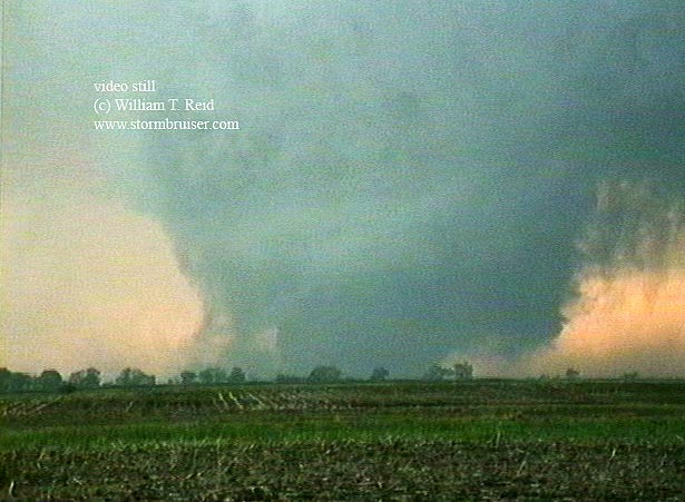
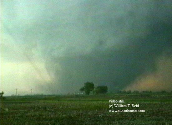
Video stills below:


Notes, thoughts, and somewhat coherent and unorganized ramblings on the Spencer
tornado chase of May 30, 1998...
***
Wow ----- it has been about ten years now since the Spencer tornado.  Time flies
when you are having fun!  May of 1998 was a rather productive chase month for
this chaser, even before the Spencer day.  I was very fortunate to have two good
friends along with whom I could share my chase vacation experience:  Keith Brown
and Cheryl Chang.  Keith and I had teamed up several times since 1994, and
Cheryl was making her first storm chase trip.  Keith and I joined forces
mid-month, but the weather pattern was lousy for several days until about May
19th or 20th.  We were on supercells in Nebraska on the 20th and 21st, while
Cheryl made her way from Calgary to Kearney.  I picked Cheryl up at the bus
station in Kearney early on the 22nd, and that evening we were on one of the
most amazing and nasty supercells that I have ever witnessed, near MacDonald,
KS.  Though Cheryl could hardly keep her eyes open, we knew that she must have
been a good-luck charm.  We decided to keep her.  On May 23rd we stumbled onto a
glorious updraft near Dodge City.  It was spitting out five-inch hailstones, in
a region without a slight risk of severe!  On the 24th we observed another very
nasty supercell near Sublette, KS.  Cheryl was batting three for three, with a
small tornado!  The weather pattern went stale for a couple of days, and we
spent some time at my sister’s home in Littleton, CO.  On the 27th we chased a
ho-hum storm in northeast Colorado, and on the 28th were on a hailstorm in
Chappell, Nebraska.  Low-level moisture was somewhat meager, and we were trying
to salvage whatever the atmosphere could muster.
***
On the 29th a moderate risk of severe was in the Day One outlook for much of
southern Nebraska.   This day wound up a total washout, however, as morning
activity worked-over the lower atmosphere.  Martin Lisius was on his way north
from Texas, anyway, and I gave him the bad news midday on the 29th.  To kill
some time, Cheryl and Keith and I visited the world-famous northeastern corner
of Colorado USGS marker, south of Big Springs, Nebraska.  Back at the truck stop
in Big Springs, we saw Dave Gold and his Silver Lining tour group.  This was the
first time that I had met Dave, and I was very impressed with his forecast
skills and analysis of the current weather situation.  Dave was in a another
league, as far as I was concerned, when it came to severe weather knowledge and
forecasting.  While I relied heavily on NWS forecast discussions to help me
figure out what to do, Dave was looking at detailed forecast charts and
soundings and was basically a walking and talking SPC office!  I did my best to
pick Dave’s brain during those couple of hours in Big Springs.  The atmosphere
did not appear to be interested in brewing a storm for us or for Dave’s group,
except for a pathetic blip out near Scottsbluff.  As sunset approached, Dave’s
group elected to hit the road for Lincoln, Nebraska, in order to be
well-positioned for Saturday, the 30th.  At the time I thought that that plan
was somewhat excessive.  Does Dave know something that I don’t?  We talked a
little about the next day’s prospects, but I don’t recall Dave being
particularly excited about it.  Won’t there be decent storms in western Nebraska
tomorrow?  Why go all the way to Lincoln for the night?  In 1998 I was VERY
accustomed to chasing on the higher terrain of the High Plains, and rarely
ventured east of U.S. 81 in Nebraska and Kansas.  If there were storms to chase
on the High Plains, then I ignored the prospects farther east.  Yes, I was still
a very naïve chaser back then, with a bit (or a lot!) of tunnel vision when it
came to where I chased.
***
If you have read the Spencer chase account above (which was written a few weeks
after the event for the TESSA Weather Bulletin), you know how much of the rest
of the story goes.  I REALLY was not too interested in driving all of the way to
the moderate risk area in Iowa, but that’s what Martin was hounding us to do
when he was pounding on the motel door at 7 a.m.  If Martin had not joined us
the prior evening, we would have likely slept in until 9 a.m. or so…..and who
knows if we would have seen a storm later on this day or not.  It is always nice
to have Martin lurking as your early wake-up call, when conditions warrant.
It is amazing when I think back on this day as to how many tiny decisions turned
out to be absolutely huge in the end.  In May of 1998, neither Cheryl or Keith
or I owned a cell phone.  We relied on my 1994-model Canon laptop computer (and
NOAA wx-radio) for data.  I could call an 800 number on the computer and
download current surface data and discussions from my CompuServe e-mail account.
All I needed was a phone jack.  So, we got all of the data we could in the
morning prior to leaving the motel room, and would usually find a truck stop or
café with a phone jack to collect more information early in the afternoon to
fine-tune a forecast.   The rest of the chase was done 90 percent with eyeballs
and brains, with help from NOAA-wx radio, and local TV and radio.  After
Martin’s early wake-up call, the next major decision was to head north out of
York, shortly after lunch.  Credit this to Keith, who was mulling over the
discussions that we had downloaded during lunch at Grand Island.  It isn’t easy
to blow off a moderate risk area and to play the slight risk area, but the
decision to move north in order to lose the high clouds and to be better
positioned for afternoon development right in front of the surface low seemed
quite reasonable.  Keith was looking at data in Martin’s vehicle, so I was
somewhat out of the loop when it came to the forecast on this day.  I was happy
to let someone else figure out the details!  Just get me to the right area code,
and things tend to work out.  I was just along for the ride, to some degree, to
see if we could wind up with a good storm somewhere.  I had absolutely zero
premonitions or gut feelings, and no high expectations on this day.  Whatever
happens, happens…it was just another chase day with a risk of tornadoes!
The next major move on our part was when we elected to blast north from extreme
northeast Nebraska to go after the South Dakota activity.  Martin’s cell phone
proved invaluable in this regard.  It seems rather peculiar now, that treading
in that direction seemed so foreign at the time.  I had not been in South Dakota
to chase before, and really did not know what to expect.  A lot of chasers back
then, myself included, seemed to have brain lock when it came to considering
chase targets outside of the normal comfort zone areas.  It was kind of like,
well, we could go into that region or state, but no one has ever chased
successfully there before and no one probably ever will, because, you know, it
isn’t Texas, or it isn’t Oklahoma or Kansas, it is north of the dreaded Sand
Hills which is the End of the Earth, and it is a zillion miles from civilization
of any kind and we might never come out alive.  Yes, it sounds ridiculous now,
but chasing into South Dakota for the first time just seemed like a really weird
concept!
***
While heading west from Sioux Falls on I-90 we were really in Fat City as far as
being in the right position to intercept the soon-to-be tornadic
supercell…except that we weren’t exactly certain where it was.  It was somewhere
to our west, not too far from I-90, and kind of lost in the murk.  Martin and
Keith were leading the way, and they exited at U.S. 81, south of Salem.  (The
updraft was likely still a good 15 to 20 miles west at this point.)  They went
north towards Salem, and passed beyond the east-west road (Route 38), which is
on the south side of town (and 3.3 miles north of I-90).  I wanted to continue
west on 38, so I stopped at the intersection and flashed my high beams at
Martin.  It was no use, it was still daytime!  We didn’t have any radios to
communicate vehicle-to-vehicle.  Lame?  Yes!  I stayed there at the intersection
for close to a minute, hoping that Martin or Keith would see me waiting back
there.  UGH.  It was no use, they just continued north, and I couldn’t figure
out why.  I raced up to them and we stopped at the north edge of Salem.  We got
out to chat about what we should do.  There was no urgency.  We were happy that
there was a decent storm to our west, which was going to be an easy intercept.
We debated as to how we should go about it.  Should we drive five miles north
and then go west?  That seemed reasonable, given that we really didn’t know the
motion of the cell, and we kind of thought that it might have a slight northward
movement ----- to the ENE instead of due east.  We had radio and TV on at the
same time in my Pathfinder.  The radio announcer (or was it the TV guy?!) came
on to give warning information on a tornado recently spotted near Farmer, SD.
That town was 15 miles to our west (and Spencer was 10 miles to our west).  The
storm motion was east at 30-35 mph, so it would be near Salem in 20-30 minutes.
Martin mentioned that we could wait for it, but I wanted to get on it as soon as
possible.  Again, we debated the merits of going north and then west, or south a
mile and then west.  We, or I, elected to go NORTH first….why?…well, no REAL
good reason except we had it in our heads that the storm was going to be moving
east-northeast.  If we could get east-northeast of the updraft, then we should
have a great look beneath the updraft base.  Since it was kind of hazy and
murky, we might need the added contrast that a view from the east-northeast
might afford.  So, we headed north!  We went maybe a mile, maybe a mile and a
half, and it started raining.  Forget that noise!  I decided to turn around on
the spot and to go back south to Route 38.  By the time we returned to Route 38,
about ten minutes had elapsed since we were there earlier (when Martin and Keith
“missed” the turn and continued into Salem.  What if they had not missed it and
had turned west ten minutes earlier when I (and they!) had wanted to?  Wow ----
that is quite a thought!  Chances are excellent that we would have taken 38 west
all of the way to the road (431st Ave) that goes north a half mile and into
Spencer.  Route 38 takes a short jog southwest at this point before continuing
west (a mile farther south).  Martin and Keith and Cheryl and I would have seen
the Spencer tornado before it was the Spencer tornado, from Spencer.  Yikes!  It
is kind of chilling just thinking about that scenario.  We would have arrived
just south of Spencer around 8:30 p.m., nine to ten minutes prior to the
tornado.  Chances are we would have backed up a mile or two as the tornado
approached the small town…
***
Storm chasing is so unique, so intriguing, and sometimes so maddening in that
the difference between great success and dismal failure, so-so positioning and
great positioning, storm intercept or no storm intercept, often comes down to
the mundane, trivial and frequent decision-making that we make throughout the
course of the day.  The spot that you wind up being at, at the critical time, is
dictated by every decision you make, or don’t make, throughout the day…and
sometimes the previous day.   In storm chasing, though, we never know when the
critical time is going to be, or if there is even going to be a critical time.
We don’t know for sure where the best place to be is going to be.  Every
decision is a judgment call, to some degree, to help keep the odds high for
getting yourself to the right spot at the right time.  If we wind up screwing up
on a big day, there is always tremendous second-guessing of ones-self and a hard
look at the blown decisions.  But, we know that these chase-decision
catastrophes are an integral part of the chase experience.  The only way to beat
the odds is to improve and to keep chasing.  On the Spencer day, we “went for
it” and did a lot of things right, luck was on our side, and a large tornado
fell into our laps.
***
The Spencer tornado was my second really big and impressive tornado, after the
Last Chance, Colorado tornado of July 21, 1993.  Between these two I had seen a
good number of tornadoes, perhaps a dozen or so, but the big ones had eluded me.
I messed up on the big days in June 1995 --- too far north on the Friona/Dimmitt
day (June 2), left too late on the Dougherty day (June 5), too late (leaving
Fort Morgan, CO) on the Pampa/Kellerville/Allison day (June 8).  I messed up on
the Wellington, KS, wedge day, abandoning my target area and going too far north
(May 25, 1997).  It seemed that my forecasting was either off a little, or I
didn’t trust it enough and I wandered off……or the good supercells that I got on
were a bit tornado deficient, or I wasn’t close enough or in the right position
for optimum viewing.  But, that was to be expected, I figured, for a relative
newbie from California.  I was still feeling my way around in my 7th spring on
the Plains.  The missed opportunities when I was out there in chase mode hurt a
lot, but I never felt like quitting and doing something else.  So, maybe I was
due for a little dumb luck on May 30, 1998.
***
The range of emotion on that day was off the charts ---- from almost despondent
beneath the featureless skies of northeastern Nebraska around 6 p.m., to
wonderment and exhilaration east of Spencer at 8:30 p.m.  Storm chasing is an
endeavor where one is yearning for these exhilarating moments.  There is really
no way to describe how fulfilling it is to find yourself exactly where you want
to be at moment like that.
***
The Spencer tornado was caught by a good number of “name” chasers...and not by
many others.  Josh Wurman and the Doppler on Wheels crew were there, as were Al
Moller, Chuck and Vickie Doswell, Bill Bunting and Roger Edwards.  Many of these
chasers were close to the tornado on Route 38 as it started to crank near
Farmer.  But, as the tornado neared Spencer, they found
themselves with deteriorating contrast and visibility due to dust and
precipitation.  Other chasers, near the Interstate to the south, had difficulty
seeing the tornado as contrast was poor.  It turns out that Martin and Cheryl
and Keith and I were the only chasers (as far as I know!)within 4-5 miles of Spencer
on the EAST side of the tornado, where the contrast against the bright skies of sunset was
excellent.   Our positioning wound up to be perfect.  There was no rain or
strong wind or interfering precipitation curtains of concern.  There was the
occasional small hailstone and nearby lightning bolt.  All I had to worry about
was getting pictures and getting the video right.  Martin had his professional
Arriflex film camera, and captured some of the finest tornado footage ever on a
large film format.
***
The four of us were rather stoked and on Cloud Nine, so to speak, at the end of
the chase.  However, we didn’t know what had actually transpired yet.  Cheryl
and I stopped at a motel in Sioux Falls just after the severe weather threat had
passed, and I looked in their phone book for the local TV station number.  I
found a pay phone and called KELO, I think.  I told the lady that I had tornado
video from earlier in the evening.  I said that if they were interested in the
footage for their news program, then they could use it for 200 bucks.  Somewhat
shockingly, the KELO lady said something to the effect: “Oh, no, we don’t pay
anything for weather video like that.”  I grumbled, “Okay, then, bye”.  I was
looking to cover some of the fuel and motel costs for the remainder of the chase
vacation, but KELO wasn’t footing the bill!
The four of us found a steakhouse, and were able to watch a TV monitor from our
table.  It was showing a local station and it was doing non-stop severe weather
coverage.  Hmmm….one would think that they might like some real tornado video to
go with that.  The news on the TV was not good, though.  We learned of the destruction and loss
of life in the small town of Spencer.  On our chase, we had stopped four miles
short of Spencer and were unaware of its presence during the tornado.  We
videoed and filmed the tornado as it was moving over and through the town, but
we couldn‘t see the town.
***
We secured rooms in Sioux Falls and reviewed our tornado video.  It looked
fantastic!  (Martin had to wait a week or two to see how his film footage
looked, and it was fabulous as well!)  It was close to midnight, and I decided
to call The Weather Channel (TWC) to let them know about the tornado footage I
had shot.  Of course, it was after midnight in Atlanta, so no one was there that
could make the big decisions on purchasing tornado video.  The person at the
other end advised me to call back first thing in the morning.  I phoned back at
7 a.m. or so, and TWC asked me to drive to one of the local TV stations that was
capable of uploading video to the satellite.  TWC could grab it off of the
satellite.  We agreed on the “normal” payment for tornado footage of $250, I
think.  TWC asked if ABC could use it for another $250.  I said, “Sure”.  The
footage was sent up to the satellite, and it was being aired on TWC practically
before I got back to the motel!  It was very cool and satisfying to see my
footage on there.  It looked great, and TWC had my name on the screen, too, as I
had requested.
***
It was Sunday morning, May 31, and the storm system that had begun in South
Dakota was wreaking havoc across much of the Great Lakes region.  An intense
derecho had evolved out of the thunderstorm complex over South Dakota and
Minnesota on Saturday night.  This event wound up being one of the costliest
disasters of the year in the United States, and was even determined by someone
to be the strongest thunderstorm event in the world for 1998!  Tornadoes and
straight-line winds of 100 mph and greater swept through New York on Sunday.
This would become a major news story, not just a weather story.  Cheryl and I
packed up our stuff and got back in the Pathfinder.  It was chilly outside, as
we were behind the cold front and northwest winds were stiff.  Keith and Martin
had left a little earlier and were going to tour the tornado path, and that was
our plan, too.  We made the 30-minute drive to Spencer, first stopping at our
film spot, four miles east of Spencer.  What would we have witnessed had we
stayed there (instead of darting south) as the tornado drifted to our southwest
and south?!  Would it have been safe?  Well, there was one clue.  The small road
map of South Dakota that had fallen out of the Pathfinder about 14 hours earlier
was still there!  A map of the tornado track (made later) shows that the tornado
passed one mile south of our photo location.  Apparently we would have been okay
there.  We continued on Route 38 and started to get into the damage area about
two miles west of the photo location.  It was farm country, so there was the
occasional destroyed grain bin, downed power poles, and dead farm animals.  When
we reached the road north to Spencer, a couple dozen vehicles were lined up
along the shoulder.  The police were not allowing non-residents or non-emergency
personnel to enter the town.  About one-third to one-half mile to the northwest
were the remains of Spencer --- large, stripped trees; battered houses, and
mangled metal.  I shot some video from the road, and had a bit of a hollow
feeling.  There wasn’t much I could do to help the little town.  Six people
perished in the tornado.
***
Brian and Nancy Morganti were there, and Brian told me of his sad chase story of
the day before.  He wound up about 25 miles south of the Spencer storm at
tornado time.  We didn’t stay too long here, as I wasn’t a big fan of touring
the damage of a killer tornado.  I think Martin and Keith had already come and
gone, and were on their way back south to OK and TX.  Chase prospects for the
next several days were bleak, as cold air spread over the Central and Southern
Plains.  Cheryl’s allotted time in chase mode was about up, so it was time to
get back to my sister’s in Denver, where Cheryl would be flying back to Calgary.
Cheryl and I left the damage scene, headed west on I-90, and stopped for lunch
at an Arbys in Mitchell.  There was a pay phone inside, so I called my friend,
Charles (Chuck) Pyke, on his toll-free business number.  I wanted to let some of
my pals know about our chase and to look for the video on TWC.   Chuck
immediately asked me if I had been in touch with my mom, as she had called him
to say that CBS and ABC were trying to locate me!  (My mom knew that I often
called Chuck on his “800” line.)   I phoned mom at home, and she said that ABC
and CBS had called for me at my home number (which they had gotten from TWC,
apparently).  ABC wanted to interview me on their “Good Morning America” show
the following morning.  CBS wanted to purchase the footage and to interview me
in Spencer the next morning, too!  WOW….and UGH….I was little interested in
this.  I was very tired and wanted to get back to Denver to relax and recharge.
My first thoughts were to not even call ABC and CBS and to blow it off.  I took
the numbers from my mom, though.  I called ABC and talked to the Good Morning
America program director.  She really wanted me to be in Spencer for a live
interview on Monday morning.  I told her I would think about it!  I called Chuck
back.  I guess I was looking for someone to talk me into doing the morning
shows, as I knew it was a once-in-a-lifetime opportunity.  Chuck did a good job
and I decided to stick around.  ABC was going to pay for a room at the Days Inn
in Mitchell.
***
I called CBS, and they also wanted to interview me in Spencer on Monday morning.
They were interested in purchasing my Spencer tornado footage, too.  By this
time I was getting pretty smart.  “Okay,” I said, “and the price for the footage
is $1000!”  The CBS guy protested some, saying that that was a lot more than ABC
had to pay (how do they know these things?).  “Right,” I said, “but apparently
this is a big news story now, you don’t have other video of the tornado, and you
seem to want it pretty bad.  The price is $1000.”  A minute later he accepted my
terms.  The remainder of the afternoon at the Days Inn was much the same.  ABC was
calling again.  CBS was calling to confirm the time of the interview.  CNN and
CONUS purchased the footage, and the tornado video was aired at the top of the
next hour on CNN!  I can tolerate an extra day in South Dakota.
***
E-gad.  The “Good Morning America” show begins at 7 a.m. Eastern Time, which
means a 6 a.m. start Central Time, which means that I need to be in Spencer at
5:30 a.m. on Monday morning.  I made the drive from Mitchell to Spencer in
Zombie Mode.  It was cold and windy still.  Cheryl and I met a TV person at the
police barricade, and she drove us into the battered town.  It was a bleak
scene, with a mangled mess of debris just about everywhere.  I spoke with the
ABC and CBS people, and did the ABC interview first, with a couple of survivors
alongside me.  I recall that the thing in my ear fell to the ground, so I could
not hear what the interviewer was saying for the last part of the piece.  I felt
kind of out of place, next to these folks who rode out the tornado in their
basements and are left with next to nothing.  The CBS interview was solo and I
did okay.  I really goofed in one respect, though.  I failed to bring my camera
equipment into the town.  Here I was, one of the few to be permitted into the
town, and I didn’t think to bring the camera with me.
***
But, to be honest, I didn’t feel like doing any picture taking.  I got the
interviews out of the way and Cheryl and I began the drive to Denver.

SPENCER LINKS

Roger Edwards' Spencer site provides an excellent and fairly comprehensive analysis of the tornado, by an SPC forecaster
who chased the tornado!  Linked from this site are first-hand chase accounts by Chuck Doswell, Roger Edwards,
Martin Lisius, Alan Moller, and myself.  My account (here) was written a few days after the event, for the Internet chase
discussion groups.
—
Also from Roger's site is a page with detailed weather data from May 30, 1998.
---
A map of the Spencer tornado path made by Brian Smith of NWS Valley/Omaha, NE...a second map here
---
Satellite Data for the Spencer tornado event from CIMMS
---
A chronology of weather events and warnings leading up to the Spencer tornado, by South Dakota Public Broadcasting
---
Event Summary by the NWS and NWS Service Assessment
---
Wikipedia page on the Spencer tornado and derecho event of May 30-31, 1998
---
PDF document Detailed meteorology of the event in an article by Wurman and Alexander for the Monthly Weather Review
This document contains great maps, detailed radar images of the tornado at very close range from the Doppler On Wheels,
and a superb discussion of the meteorology and evolution of the Spencer supercell and tornado. This is a MUST READ for
any and all students of severe weather!
---
Article on the lightning activity associated with the Spencer SD supercell and associated activity
---
Video of the Spencer tornado by Martin Lisius, Keith Brown, and William Reid, from Martin's Stormstock web site.
You will have to scroll down just a little to find the link(s) to the Spencer clip. On some of the zoomed-in video
by Keith and Martin, you will see myself and Cheryl and the Pathfinder, with the tornado writhing behind us.
Leave a Reply
You must be logged in to post a comment.