
The last tour of the year was over, and I was driving from Oklahoma City to Avon, CO. As sunset approached I was careening at… [Read More]
Archives for June 2006
June 29, 2006 Monument Rocks, KS
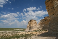
A neat rock formation rises from the flats of southern Gove County, KS. We were there at mid-afternoon while waiting for storm initiation, and the… [Read More]
June 28, 2006 The Middle of Nebraska
We were not expecting much in the way of storms, nor were we expecting storms. And, the only thing that we saw that was in… [Read More]
June 27, 2006 Beatrice, NE Hailstorm and rainbow
June 26, 2006 Dodge City radar dome

During the lecture tour with Charles Doswell, we occasionally get the star treatment at the NWS offices on the Plains. On this day we chased… [Read More]
June 25, 2006 Santa Rosa, NM CG
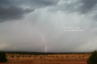
Activity on this day began near Santa Fe, NM, and dove southward. We managed some lightning photography during the daytime near Santa Rosa.
June 24, 2006 El Paso County, CO storm at sunset
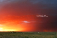
Something finally worth looking at on this day, a bit east of Colorado Springs. I caught one decent lightning strike and thought I had a… [Read More]
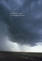
June 23, 2006 Agate, NE supercell and mammatus
Wow, a beautiful supercell near Harrison, NE (in the extreme northwest corner of the Nebraska Panhandle) was photographed from the south, near Agate along Hwy… [Read More]
June 22, 2006 N TX Panhandle squall
Shear was weak on this day. We began tour 6 out of OKC and headed for the northeastern TX Panhandle, near Borger. The late-afternoon cells… [Read More]
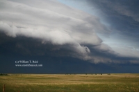
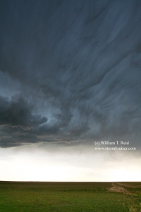
June 20, 2006 Yuma County, CO Severe cells
These storms in eastern Colorado displayed some supercell characteristics, replete with lowerings and dusty spinups beneath the updraft bases. The storm at sunset west of… [Read More]
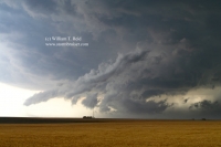
June 19, 2006 N. Lincoln County, CO high-based gusters
Eastern Colorado has been mired in a drought since the turn of the century, so the ground was dry on this day and low-level moisture… [Read More]
June 17, 2006 Cherokee, IA Heavy Storm
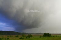
Hey, I couldn’t call it severe or a supercell, so I went with “heavy”. There was heavy rain, and some signs of organization, but not… [Read More]
June 15, 2006 Burnstad, ND Supercell
It took a while, but storms finally fired towards sunset in south-central ND and moved northeast. We were in front of a cell in Logan… [Read More]
June 14, 2006 Baker, MT Severe cell

A nasty supercell was cranking near Miles City, MT and we were in front of it as it elongated and weakened somewhat between Miles City… [Read More]
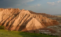
June 13, 2006 Red Shirt, SD Badlands Supercell
This high-based cell provided some good-sized hailstones near Red Shirt, in extreme northwest Shannon County, SD. As the cell drifted off to the east, it… [Read More]