Short version:
This was one of those days where you basically do everything right, but nature conspires against you. We were on a beautiful supercell from its developing cumulus stage to dark, about six hours later. The storm had a nice tornado with it for about ten minutes, but we only saw the final part of the rope-out stage due to obscuring rain.
Long version:
Shortly after lunch in Boise City, storm towers developed near a surface low in Baca County, CO, to our northwest. We scooted north on 287 and waited for an hour or so as a couple of cells slowly developed. The two cells drifted east of 287, and we stayed in front of them on section roads east of Campo, in extreme southeastern Baca County.
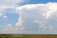
The southern cell eventually became the real thing, and we found ourselves a few miles east-northeast of the updraft base around six-o’clock magic time. The pictures below were taken along Road 45, about 17 miles east of Campo and five to eight miles north of the CO/OK border.
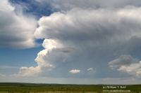
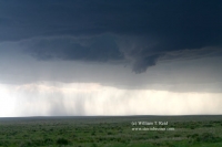
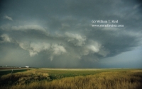
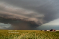
The first image among the first four shows a lowering on the updraft base, perhaps a relatively shallow wall cloud. It is about four to six miles distant, and the view is to the west-southwest. Wrapping rain curtains are behind (west and west-southwest of) the wall cloud. This is the beginning stage of a transition to HP (high precipitation) mode for the supercell. We are on the southern edge of the forward flank precipitation area, so we had occasional light rain and small/moderate hail.
(a little lesson in HP-ology follows…)
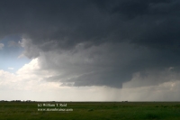
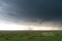
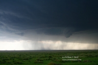
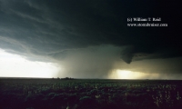
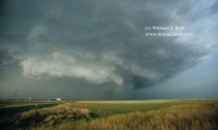
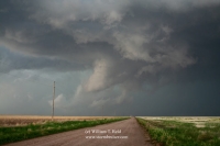
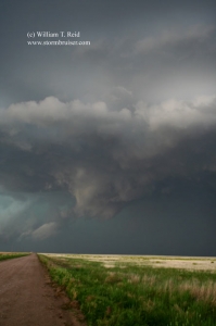
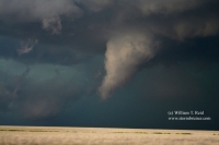
The next image is a wide view a little later, looking southwest to west-southwest. The updraft base is rotating, and there is a prominent “cut” into the rear of the base, associated with the rear-flank downdraft (RFD). The RFD works its way into the lower portions of the updraft and erodes cloud material as it descends. It is easy to see the cyclonic (counter-clockwise) curvature of the “RFD cut” from the rear of the updraft base (on the right side of the photo) and towards the center of the base (in the center of the photo). The RFD cut bumps up against a lowering just to the right of center. This lowering is a stubby funnel cloud. We did not observe strong rotation with the funnel cloud, but it persisted for quite a while and the flow through it was strongly upward. The precip curtains in and behind the RFD cut (behind the funnel) are moving right-to-left and are gradually wrapping west, southwest and south of the funnel cloud. When a supercell transitions to HP, these precip curtains eventually wrap most, if not all, of the way around the center of circulation, typically obscuring any funnel or tornado activity. A radar image would show this as a “hook echo”, or maybe even a small closed circle. Tornadoes sometimes form as the precipitation curtains are wrapping around the updraft base. if one wants to view any tornado from a safe distance of a few miles or so with an HP cell, then one usually needs to be east to northeast of the tornado, as this sector is last to have any visual obscuration difficulties. It is also a sector prone to rain and hail, occasionally large hail. The next photo is a tighter shot of the “action area”. The fourth image above is a few minutes later, and shows that the wrapping precipitation curtains have migrated south and southeast of the action area in the center of the updraft base. If a tornado were to form at this time, then anyone south of the updraft base and looking north would have obscuration issues due to the intervening precipitation.
So, in short, we were in the right place at the right time at this point in the storm’s evolution, but strong rotation was unable to work its way from cloud base to the surface (or vice-versa!).
I was nervous as the storm neared and began to turn to the southeast somewhat. The nearest paved road looked to be 15 miles away in all directions, and if we got caught on this dirt and gravel road then we risked getting stuck in the mud, subject to the whims of the supercell. I had options only to the north, into the hail core and soon-to-be muddy roads—-not good—-and to the south, by cutting just in front of the circulation and playing chicken with the wrapping precipitation curtains. We blasted south, got into a little bit of the precip, and were very relieved to see the road turn to pavement at the OK border. It would have been very dicey had the road remained unpaved into OK, as our vans don’t do very well when some of these dirt roads get wet.
The next part of the chase was along 412, and we were unable to see into the action area of the HP cell to our north. Here is the view to the north, from a mile south of Keyes, OK.
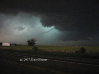
The photos below show a prominent lowering, but there was no rotation with it. It was south of the RFD cut and the real action area. As the cell moved ESE, we finally wound up very close to the tornadic circulation just NW of Guymon. We saw the final stages of the tornado that some chasers caught (see photo of funnel by Katie Heester below), and were again in the notch just N of Guymon. The cell tried hard again to tornado as it approached Guymon. Fortunately for the town, it appeared that the rain-cooled air won the battle versus the inflow and nothing significant developed. However, even though we were on pavement, we had to deal with part of the precip core and some small hail. I don’t like subjecting the rented minivans to hail, but sometimes it is impossible to avoid when you are anywhere near the notch.
That funnel-shaped appendage above was NOT rotating! And, on that last image, it appears that I clicked the shutter just as a lightning flash was commencing (note the small white blotch).
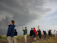
Images below courtesy of Katie Heester:


Leave a Reply
You must be logged in to post a comment.