Short version:
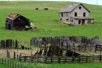
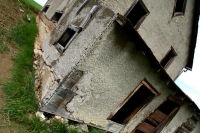
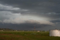
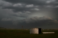
Brian and I spent some time exploring an abandoned farmstead west of Union Center, SD, and then were compelled to blast west towards some new storm development west of Gillette, Wyoming. As we approached Gillette, we were greeted by a gorgeous laminar shelf cloud on the south flank of a severe cell. However, we were on I-90, and did not exit soon enough to get stills. By the time we could exit at Gillette, the nice storm structure was above us, and strong outflow winds were about to smack us from the west. We backtracked towards Rozet, and observed a suspicious lowering to the north. The cell fell apart quickly thereafter. Storms cranked up again towards dusk near Spearfish, SD, with some tornado reports. We were in rain behind the action area and saw an overturned big rig. When we broke out of the precip near Sturgis, there was some strong wind but no obvious tornadic activity nearby. On the way back to Pierre we had some nice CG activity to watch, but it wasn’t frequent enough to photograph.
Extended version:
When you wake up at 9 a.m. and find powerful thunderstorms slamming your general target region, then one thing is for certain: uncertainty. Brian Morganti and I were in Pierre and thought that the E-W boundary through SD could be in play late Saturday. However, clouds and rain through midday really did a number on the low levels. This forced us to look west towards SE MT and NE WY, which were covered by a moderate risk for severe wx.
We stopped for 30 minutes to photograph an abandoned farmstead along Route 34 near Union Center, and were in Sturgis by 4 or 5 p.m., depending on the time zone. Our tentative target area was the MT/WY/SD triple point area near Belle Fourche. Data stops at Sturgis and Spearfish suggested that the best instability and theta-e air were maybe 40-60 miles south of I-90 in NE WY. Storms were firing near and south of Buffalo, to the west. An isolated supercell was trekking towards Glasgow, too far to catch. (It had been plugging away for several hours already, and would finally croak as it hit the ND border near 11 p.m.!) We elected to continue west on I-90 to reach the storms west of Gillette, though I was a little nervous about something bigger perhaps going up behind me near the Black Hills. As it turned out, that concern proved unfounded as the air in SD had been so worked over by the earlier convection that convective inhibition ruled the day.
A storm NW of Gillette became severe warned as we fueled up in Moorcroft. This was an easy intercept, and we headed west on I-90 to Gillette. A very cool-looking, greenish, banded and tiered-shelf structure quickly came into view as we approached Gillette. We would have liked to have stopped to set up to photograph this, but we had to keep going to Gillette. It appeared that any action area might have been north of Gillette by maybe 5 miles or so, so we considered going north out of Gillette. However, we found ourselves in dusty outflow just as we exited I-90 at Gillette. We turned back east to the Rozet exit to set up tripods, in front of the cell and east of the dust. The banded structure was not nearly as impressive as 10 minutes earlier. There were plenty of CGs out of the anvil to our N ond NE, and an interesting wrapped-up and lowered “notch” area perhaps four miles to our north. It looked like a tornado might be trying to develop north of Rozet for a few minutes, but this area became hidden in rain and weakened. In fact, the entire storm weakened extremely rapidly and was pronounced dead not more than 10 minutes later.
A couple of cells were to our south and SSW, the western one tornado-warned near Wright, WY. These were in the good CAPE axis, so we went from Moorcroft to Upton to get a look at these. We could see the base of the eastern cell from Upton, but it did not look like a decent supercell visually or on radar. The tornado-warned cell looked junky on radar. Meanwhile, the activity which had died east of Gillette was re-strengthening as it approached Sundance. We high-tailed it NNE to Sundance from Upton on 116, but wound up in heavy rain and some small hail before we could reach the Interstate. We were behind this storm now, which was becoming linear (NNE-SSW) and moving east at 30-35 mph.
The drive from Sundance to Spearfish was slightly nasty due to heavy rain, but we were nearing the front edge of the activity. Just as we got to Spearfish, a 103-value “wheel-of-fortune” shear marker popped up on the Threatnet radar display, right over Spearfish and right over our location. A minute or two later, the NWS issued a tornado warning for our locale. We had fairly strong winds from the north or NW, but were still in heavy rains and low overcast. We couldn’t see what was going on. A few miles east of Spearfish we were in quite strong northerlies, it was dark with plenty of lightning, though still prior to sunset, around 8:20 p.m. MDT. We still could not see anything. We came upon a semi-truck on its side. It was going westbound on I-90 and had been turned over onto the left shoulder of the westbound lanes. Someone was already there assisting the driver, and we continued east. NOAA radio came in with spotter sightings of a tornado between Spearfish and St. Onge, just to the north of the Interstate, and a little later of one near Deadwood, moving towards Sturgis. We got out in front of the precip finally just west of Sturgis, after driving through a dramatic wind-shift from northwesterly to southerly in a matter of seconds. But, though there was plenty of daylight left, we did not see any interesting wrapped-up area which we might consider tornadic. Apparently we were about 3-5 minutes or so late from having a tornado go right over us…..or 5-8 minutes late from being just east of this “event” and perhaps seeing something. Our little excursion down to Upton to check out those southern cells cost us…..or, saved us.
We stopped at Sturgis to put some gas in Brian’s SUV, and cut it short at five gallons as the town started to get blasted by strong NW winds. The activity moving through was still linear for the most part, but there were occasional kinks which would wrap up briefly and then weaken quickly. We had a good view of one of these which looked like a little supercell briefly about 20 miles east of Sturgis, in the fading light. A mildly entertaining CG show kept our attention about halfway to Pierre. We got in to the Super 8 in Pierre a little after midnight.


Leave a Reply
You must be logged in to post a comment.