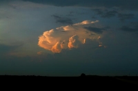
Brian and I got out of Pierre by 11 a.m. and targeted the Grand Forks, ND, area. The cap was strong, and held until nearly sunset. An elevated supercell developed to the west near Devils Lake. We had an easy intercept course, but the cell was above cool air and a low stratus deck. We dove south to get out of the muck and could see the top of the storm south of the cool air boundary.
extended version:
To those of you who had wished they were up in eastern ND on Sunday:
You didn’t miss much.
Computer models were painting a pretty nice picture for late Sunday, with a closed surface low west of Grand Forks, nice easterly winds north of a warm front, dew points near 70F just south of the front, and very favorable flow aloft. Brian Morganti and I motored north from Pierre, SD, to Dawson, ND, east on I-94 to Fargo, and north to Grand Forks. We were right on the warm front at Grand Forks from about 5:30 p.m. to 7 p.m. Mushy, low-topped cumulus did not seem too interested in becoming storms. Finally, around 7:30 p.m., a few towers were trying to go up to our northeast, a little north of the front, and a new cell was developing just south of Devils Lake, 80 miles to our west, right on the front! There was a problem, though. It was cool and cloudy just north of the front. Allow me to expand on this. IT WAS TOO BLOODY COOL AND CLOUDY JUST NORTH OF THE FRONT AND IT WAS COOL AND THERE WERE LOW CLOUDS AND IT WAS MURKY AND THERE WAS BEEPING AND FLASHING, AND THE COOL CLOUDS WERE BLINKING AND FLASHING AND THEY WERE BEEPING IN THE COLD CRAPPY MURK NORTH OF THE FRONT AND WE WERE UNABLE TO SEE JACK SQUAT AAAAAAAAAAArgh.
Hang on, I’m getting ahead of myself here. We elected to target the cell near Devils Lake to our west. At Larimore, west of Grand Forks by about 25 miles, we found ourselves north of the front, in weak northeast winds. The temperature had plummeted to about 69F, and very low clouds were floating around willy-nilly. We dropped south to Northwood on 18. This put us back near the front, with low clouds to our north. We could see the storm’s updraft tower to the WNW as we headed west to McVille on 15. But wait! Here come the low clouds again, lower than ever! The warned-cell’s storm tower disappeared from view. We were 25 miles southeast of a perfectly good supercell, and it was moving east along the front, AND IT WAS BLINKING AND IT WAS FLASHING ABOVE THE COLD FREEZING MURK NORTH OF THE FRONT AND IT BLINKED AND IT FLASHED AND WE WERE BEEPING AND FLASHING WHILE IT WAS FLASHING AND BLINKING AND IT WAS TOTALLY OBSCURED AND ALL WE SAW WAS LOW OVERCAST AAAAAAAARRRRGH.
Anyway, a new storm was developing well south of the front, near Jamestown. Since the Devils Lake storm was invisible from the surface of the Earth within 20 miles of it, we headed south on Highway 1 to check out the Jamestown storm. We emerged from the low cloud murk and into the nice warm and humid air near Binford, and were afforded a view of the nice storm tower and back-sheared anvil of the elevated Devils Lake storm, about 25 miles to our NNW. It had a good look on radar. It was odd driving away from a powerful storm which was in a Tornado Watch.
The Jamestown storm also had a nice look on radar for a couple of scans. The surface winds at Jamestown were not exactly ideal, though—-southwest at 8 mph or something like that. The NWS severe-warned the cell, and then the next one just to its NNE in Griggs County. We got in front of the Griggs County storm at Hannaford. There was a decent updraft base and plenty of CGs…the quick staccato kind that suggest a very severe storm. We were not impressed by the base, though. There was little or no rotation apparent, and the cell quickly fell apart. Which is worse: a) driving 500 miles and not being able to see a supercell which is right next to you, or b)driving 500 miles to see a severe storm croak, or c) both a and b?
The Hannaford storm dropped a pea-sized hailstone on us, and it was dark, and we dropped down to I-94. The light show was pretty good, but most of the bolts were shrouded by clouds and precip. We went east to Fargo and south a little and found ourselves in the path of a bow-echo-like feature. Near Hickson we were blasted by heavy rain and strong westerly winds. I pulled the SUV to the side of the Interstate and stopped. The vehicle was rocked quite strongly by the winds, and we noticed a gust to 61 mph on Brian’s wind speed display. Speeds could have easily been stronger a little prior while we were slowing down to stop. I phoned in the wind speed report to NWS Grand Forks, and only minutes later their wx-radio statement mentioned our 61-mph wind speed measurement!
The storm moved on and we found a room in Sisseton at 1 a.m.


Leave a Reply
You must be logged in to post a comment.