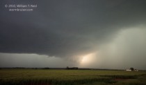
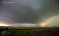
This day featured much consternation and a pretty good western OK supercell. The consternation was due to a mechanical breakdown on one of the tour vans. Our 2-van tour group began the day in Woodward, and again were targeting western OK, close to the TX Panhandle border. Brian and a few guests had to leave Woodward a little early in order to pick up another guest around 11 a.m. in OKC. In the meantime, I and the remainder of our group killed some time in and around nearby Arnett. After washing the van and poking around an ancient Arnett motel, we drifted south to Cheyenne to meet back up with Brian. Unfortunately, the alternator on Brian’s van gave up the ghost as he neared Cheyenne. He was able to limp into the town, and we had to figure out how to salvage the chase day and get the van operating again. After a bunch of phone calls, gnashing of teeth, and a false start towards Woodward to pick up an alternator, I elected to drive to Elk City with Brian to pick up a rental minivan. We managed to make it back to the waiting guests in Cheyenne as strong storms approached the town from the southwest! A cell not too far from Erick and Sweetwater looked good for a little while, but then became poorly organized as it reached our location near Cheyenne. Another cell south of I-40 beckoned, and we blasted south towards Sayre. Like the day before, this cell produced a tornado (near Vinson) a little bit before we could get on it.
————
Our chase exploits are detailed in this account that I wrote for the chase community late on the 12th:
————
After spending two hours mid-afternoon trying and failing to get a new alternator for the van and then renting another vehicle in Elk City (for the tour group), Brian Morganti and I left the dead van in Cheyenne, OK, and drifted south to a newly warned cell near Erick. We couldn’t make it south and west in time to see the tornado that was reported near Erick. The cell looked good for about 15 minutes and then weakened as it approached Cheyenne, in part due to seeding from a strengthening cell or two to its SSW.
We then headed south for the biggie tail-end stuff not too far south of Sayre. GRLevel 3 showed a pair of impressive cloud tops —- above 55,000 feet. Surprisingly, perhaps, the northern one of the two had the best look at low levels. At Sayre we were in moderate anvil rain and were treated to a staccato-type CG barrage. This was a beast of a cell—based on the CGs it was issuing! We went 7E of Sayre and dropped south towards Carter, and stopped 3N Carter to watch the supercell and the large wall cloud to our WSW. We had a view into the notch area and saw tail-cloud-like inflow from the north, but tight low-level rotation seemed minimal. Again, this was the northern action area—-a less-impressive action area was beneath the southern portion to our SW.
When light rain hit our location, we baled south to Carter and sped east inside new wrapping precip curtains beneath a new meso area. We got out of that unscathed, but I bet that some of the Vortex bunch got munched in and around Carter.
The next notable moment was a few miles north of Sentinel. We looked west, and some 7 or so miles away saw what looked like a classic RFD cut AND a large tornado…and I was about 90 percent certain that it was a tornado…but there was no tornado warning at the time and it was distant and now I am totally uncertain whether it was or not. (Maybe nobody else but our group saw this —- yea, right!)
However, another decent “tornado cyclone” or meso soon developed near Burns Flat, and we closely trailed that for 10 or 15 minutes and were inside the Bear’s Cage with it a bit, but the best the bear could manage was a wall cloud and brief funnel activity. A couple of impressive funnels were observed later towards Clinton, and it was then dark and time to pack it in.
I’m back up at Woodward tonight to pick up the new alternator tomorrow morning —- great fun.


Leave a Reply
You must be logged in to post a comment.