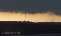
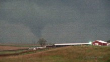
We began the day in Dodge City, with a target of somewhere around Atwood, KS, in the northwest part of the state. A warm front would be lifting northward through the region towards sunset. We waited along I-70 near Grinnell for a fast-moving cell which was approaching from the south. The cell dragged us north to Hoxie, but we gave up on it a little farther north as it remained unimpressive and poorly organized. A cell approaching Goodland from the south looked good on radar, so we blasted back to the west-southwest through Colby. As we neared Goodland, we spotted a “pencil-thin” tornado south of the Interstate a little after sunset. It was well to our west-southwest. (Yes, the best video still that I could manage was the one with the tornado directly behind the highest object within 50 miles.) From Goodland, we scooted north a few miles on the heels of the supercell. Another, more-impressive tornado was intermittently visible in the lightning flashes a few miles to our north-northeast. We were near the Goodland Airport at this time (0209Z), and the personnel at NWS GLD witnessed the tornado, also. Naturally, it looked better a little before I managed to get video of it.
Today’s storms were fast-moving and required a lot of driving. I shot no quality stills pictures. With western South Dakota looking like the hot spot on the 24th, I booked rooms farther north, in Imperial, NE. It was a long and wet drive from Goodland to Imperial.


Leave a Reply
You must be logged in to post a comment.