 This was another chase day with a somewhat uncertain target area. We began at Murdo, SD, and chasers had two target areas in mind —- from around the SD Badlands to the Faith area, and southwest of there around the extreme northern Nebraska Panhandle. These were my typed thoughts around 1630Z (10:30 a.m. MDT):
—-
I like the surface easterlies (progged to be) just north of the surface low in the northern NE PH—-beneath the southerly flow at 700 mb. The best moisture at low levels appears to be along the NE/SD border. The cloudiness in western SD and nw NE is a bit scary currently. I prefer the area around Chadron to that from Rapid City to Faith in part because the cap seems to be a big player again, and a storm would be more likely on the higher terrain, and the area towards Chadron and Lusk is a little closer to the stronger flow progged for 00Z by the 15Z RUC. With such nice turning at low levels from east to south, I think that tornado prospects are pretty good today.
Having said all that, I may hold up a little east of the Black Hills and monitor surface and satellite trends early this afternoon before committing to the area south of the Black Hills. We are making our way west to Kadoka currently (1630Z).
—-
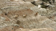
Bob Smith and I and the Tempest group did some quick sight-seeing in the Badlands midday, and stuck close to I-90. The thick high-level cloud cover was sickening. By about 2:30 p.m. MDT I was ready to abandon this area:
—-
After much consternation, I have elected to head towards the WY/NE/SD triple point area. We have been sitting beneath the bleak and cold cloud deck at Wall, SD, this afternoon. Some clearing and great instability are not too far east of Wall, and some models make some big storms in C SD later. I was very tempted to go with the Matt Crowther line of thinking of the Plains area from about Howes to Pierre. But, something just tells me that today I should be on the higher terrain in those easterly surface winds south of the Black Hills. Perhaps the biggest factor is that it has been sunny all day out there near Lusk, and the northern NE PH is clearing out some now.
Leaving Wall at 2030Z and blasting to RAP and then diving south…
—-
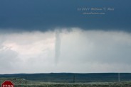
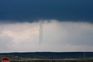
As we dropped south and west to Crawford and Harrison in the northern Nebraska Panhandle, an impressive supercell with a very strong updraft developed several miles south of U.S. 20 near the WY/NE border. The paved road network in this area is horribly sparse, and we were confined to U.S. 20. The storm’s updraft base and action area were several miles to our southwest, and occasional low clouds were interfering with our view. We were stopped about three miles east of Harrison, and had the tripods set up and the camcorders running. As the precip core neared from the west, it was time to bail east some. And, as luck would have it, right as we started to move, a slender tornado appeared to our south. It was a few miles distant, and persisted for a couple of minutes.
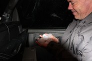
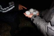
We were again chased east on 20 by the precip core. The cell looked ready to produce again, with a nice pregnant base and wrap-around precip curtains just to our southwest. We were able to watch this get close, but were forced east once more through the hilly/canyon/bluffy area between Harrison and Fort Robinson. During these few minutes “the public” reported another tornado to the NWS, ten miles east of Harrison. We did not observe this event, which was behind us and behind the higher terrain (assuming it is a legitimate report). The storm continued in primarily HP mode towards Crawford and north of Chadron, and we let it go. On our way to Alliance, we waited for another strong supercell to clear the highway, and found tennis ball and baseball-sized hailstones in the grass about 15 miles south of Chadron. I reported both the Harrison tornado and hail observations to the NWS in Cheyenne.
So, it seems that I made the right chase decisions on this day, as we wound up on a tornadic supercell and witnessed a tornado! Severe storms (and a tornado or two) occurred in the alternate target area in western SD, but this activity waited until a little after sunset for initiation. It was great seeing the Harrison tornado, but I wish I had had a better view of the storm structure and updraft tower. I only took a few still images, as we were generally battling the low clouds on the cool side of a boundary for the entire chase. It is too bad that U.S. 20 was not about 7 miles farther south! The hail pics below are courtesy of Bob Smith.

Leave a Reply
You must be logged in to post a comment.