 May 22, 2011 is the date of the devastating Joplin, Missouri tornado. The forecast on this chase day appeared relatively clear-cut, though there was a very large risk area to consider. Our Tempest Tours group (including Brian Morganti, Chris Gullikson, Chad Cowan and Tank Dickson) was in Emporia, KS, and big tornadic storms appeared possible in a large and long swath from northern TX to northern WI! In SPC’s 1630Z outlook, a 10 to 15-percent hatched tornado risk was painted from near Ardmore, OK, northeastward through most of eastern OK, central MO, and north along the Mississippi River from St. Louis to western WI. Can you say “tree chase” boys and girls?
Many chasers in the DFW/OKC corridor were contemplating a jungle chase near and east of I-35 in southern OK. I saw no need to head that far south, as indicated in my brief forecast post to CFDG around 11 a.m.:
Models agree on storm formation in extreme SE KS today, near Parsons. CAPE is forecast to be off the charts and winds aloft are more than sufficient for speed and directional shear from the surface to 500. The RUC and NAM suggest a small back-bent lobe of high CAPE/convergence in extreme SE KS—-this area looks to be right in front of a surface triple point. We have an easy drive from EMP this afternoon.
We had enough time to grab some lunch in Yates Center or Iola, and then continued towards Parsons. Convection began somewhat early in the afternoon not too far west of Parsons! From about 3 p.m. to 5 p.m. we were east, then southeast, then south of the action area of the slow-moving HP supercell (which was near Parsons).
The storm seemed reluctant to push eastward, which made it easy to stay with, but it was dumping a lot of precip in the same area and generating cool north outflow winds. As 5 p.m. neared, the storm appeared to be a poorly organized and messy HP, and in my NOW cast post I aired my observations:
We have been on the Parsons KS cell for a couple of hours, and it continues to backbuild so that it is practically stationary. No tornadoes with it yet, apparently. South of the core, it is spewing out cool air from the north (7S of Parsons). I suppose the best play is towards the SW edge where new development continues and where good surface air might have a chance to get beneath an updraft base. Any other ideas?
I was frustrated with the storm, as it was undercut by its own outflow and it did not seem to be a tornado candidate. I discussed our options with Chad and Chris, and we were a bit unsure as to how to proceed. We drifted west on U.S. 160 a few miles to Mound Valley, I believe, for a pit stop. We thought that by positioning ourselves towards the southwest edge of the cell (well, perhaps I should say “storm complex”, as there were three separate but bunched-up cores aligned west-to-east), that perhaps a big new updraft on this side of the storm could materialize and feed on unspoiled inflow (850 mb flow was very strong and moist and out of the SSW). Well, I should have incorporated one of my chase mantras — one that should be taped to the dashboard of the van — “when in doubt, error to the east”. By doing this, I would have left more options open.
As it turned out, our attention towards the west side of the Parsons-area complex put us out of position to get on the Joplin tornado. After the pit stop, the guides and I continued to be unimpressed with the look of the nearby supercell, and we decided to focus on new strong convection not too far to our south, in extreme northeastern Oklahoma. We dropped south to 166 and blasted east, in order to be able to drop south in front of supercells which were developing near Miami, OK. Along 166 west of Chetopa, we could see the back end of the storm updraft which was associated with the developing Joplin tornado. The in-cloud lightning with this storm to our east was quite impressive, and the radar was beginning to indicate strong low-level rotation. HECK! This was relatively new development on the east side of the (seemingly junky) Labette/Cherokee counties storm. Something happened quickly to trigger the massive new updrafts just west of Joplin; perhaps the low-level jet was strengthening or shifting a little to the east. Regardless, we were watching from about 20-25 miles away and could not catch up, as it was moving east at at least 30 mph. Joplin was in the path, and an EF5-rated tornado destroyed much of the city and killed more than a hundred people. This would turn out to be the deadliest tornado in the United States in about 50 years.
Well, I was definitely NOT pleased with the turn of events from a tour director’s standpoint, as I and my guests were missing out on an historical event. But, maybe things happen for a reason. One chase tour company was in Joplin when the tornado formed, and was fortunate to narrowly get out of the way in time. Another tour group came up to the city just after the tornado, and went into search and rescue mode. Who knows how our day would have wound up had we remained on the east side of the Parsons-area activity?!
I was also NOT pleased or confident in our prospects for the remaining daylight hours. Though severe storms and supercells were organizing not too far away, I feared that we would find it very difficult, if not impossible, to see anything, given the nasty chase terrain and wet nature of the storms. A look at the map around the OK/MO/KS/AR area, and one sees lakes, forests, caves, rivers, scenic routes and very crooked roads —- a NIGHTMARE for a storm chaser! I thought we were done.
But, press on we must. A supercell south of Miami had a tornado warning and was moving east near Grove, OK. A mile after entering Missouri on Route 10/Missouri Road U, I had Chad and Chris steer the vans southward along Highway 43. We needed to quickly scoot south about 20 miles. Along the way we were treated to some sharp curves, deep ravines, and nasty forest conditions on both sides of the road! If this persisted, then we would be lucky to see the tornado if it were directly overhead! Luckily, after about 15 miles (a tad south of the highway west to Grove), we found ourselves with open farmland to the west! We seemed positioned decently with regard to the approaching supercell and stopped at a relatively elevated observing spot. The storm had a tornado reported with it, but we were still in moderate rain and murk and haze and could not see very far. The action area was still perhaps five miles away to the west. We went a couple of more miles to the south with the hope of getting out of the rain and finding better visibility. Again we stopped along the west side of Hwy 43, just north of the intersection with Route 90, and just south of the Simmons Foods poultry processing plant.
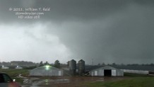
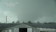
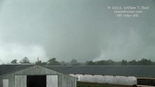
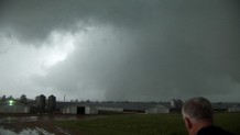
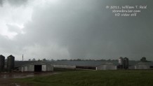
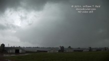
Well, it was a little better here, with some indications of clearer skies to the WSW and maybe a little low-level cloud structure to the west. After a few minutes the rain let up and a good-sized tornado emerged out of the murk to our WNW! (The time was 7:22 p.m. CDT/(0022Z). It was a barrel beneath a very low cloud base and it was headed to the east, to our northwest, so we were safe to view from here. Chad called 911 to have the sirens sounded —- Southwest City, Missouri, was only a mile and a half to our southwest. It looked like only open farmland was being impacted by the tornado, thankfully. A strange “roar” of sorts was coming from the direction of the tornado, and I found it difficult to believe that something that was perhaps two miles distant could be making that sound! It sounded kind of like the muffled roar of a distant jet engine. I thought that maybe some loud fans or machines had been turned on in the nearby chicken coops, but that was not the case!
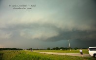
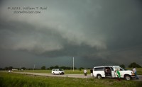
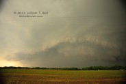
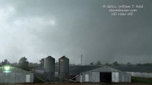
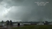
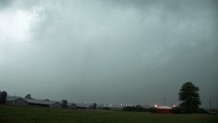
The tornado maintained its beefy and large appearance for several minutes, but as it moved more to our NNW, the contrast around it decreased markedly, precipitation wrapped between us and the tornado, rain fell at our location, and the funnel appeared to shrink considerably. With visibility deteriorating and with the tornado disappearing to our NNW and north, I elected to drive a little bit to the east on nearby Route 90 to stay safe, to stay with the storm, and perhaps find less wet conditions. This was at 7:30 p.m. CDT. Here are some video stills of the Southwest City, MO, tornado taken from 7:22 to 7:28 p.m. CDT…note how the tornado becomes completely obscured to the north-northwest in the final image:
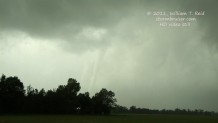
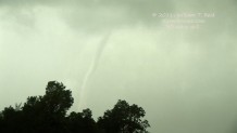
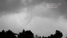
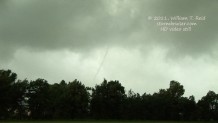
After only a mile or so east on 90 a long and slender funnel came into view to our northwest. We stopped again, and watched the rope out phase, about a mile and a half distant. Leaves and small debris drifted out of the sky in our vicinity for several minutes.
I had the option of heading east on Hwy 90 to stay with the cell, but the road jogged right into the storm’s path, and looked to be mired in nasty hills and forests. Forget that noise! We dropped south through Southwest City on 43 and waited for the next supercell, very close to the OK/MO/AR triple-point. This storm arrived and lacked impressive, notable, sustained low-level organization. We watched it move away to the east, and our chase day was over.
With a little bit of daylight remaining, we ventured north on Stateline Road from Southwest City and came upon downed utility poles and severely damaged farm structures. This was close to two miles to the northwest of our viewing location, and this is where the tornado crossed from Delaware County, OK, into McDonald County, Missouri. We battled heavy rain and occasional hail as we made our way west to Grove for a convenience store dinner, and I booked rooms for the group in Tulsa.
Somehow we managed to salvage the day and wind up with a big tornado, rated EF-3 —– not bad! Even better, this tornado caused no deaths and few if any injuries.
Here are some links to video of the Grove, Oklahoma, tornado:
Link One, by Matt Crowther and Betsy Abrams, as the Grove tornado developed southwest and south of Zena, northwest of Jay.
Link Two, by Matt Crowther and Betsy Abrams, looking north and then northeast from Hwy 59, about 6S of Grove, as the tornado strengthens considerably and continues to the east.
Link Three, by Justin Teague, looking south at the strengthening tornado along Hwy 59 south of Grove, and a brief look at the semi-wedge stage near the OK/MO state line.
Link Four A and Four B, by John Monteverdi, wide view of the storm and tornado looking south from Grove, OK.
And, some links to video of the Southwest City, Missouri, from those of us in the Tempest Tours group:
Link Five, by Tempest guide Chad Cowan, while he is in contact with the 9-1-1 operator.
Link Six, by Tempest guide Chris Gullikson, including a fabulous wide-angle view time lapse of the supercell and the tornado as it becomes visible to our WNW.
Link Seven, by Tempest guest Lisa Beal
Link Eight, by Tempest guest Darren Lo (I think!)
I am unable to locate any other video online of the Southwest City tornado (as of early October, 2011).
NWS Springfield, Missouri, links regarding this EF-3 rated tornado are here and here. (You may have to scroll down to find the Southwest City tornado.) The “Southwest City” tornado was a continuation of the “Grove, OK” tornado which began at 6:52 p.m. CDT, 2.5 miles WSW of Zena, OK (or about 7 miles southwest of Grove). The survey team from NWS Tulsa rated the tornado at EF-3, determined a maximum path width of 1550 yards (0.88 miles), and a path length of 16.5 miles up to the Missouri border. The tornado traveled another 1.5 miles approximately in Missouri, giving a total path length of 18 miles. The tornado entered Missouri at about 7:26 p.m. CDT, and ended at 7:33 p.m. near Hwy 43, 2.2 miles NNE of Southwest City. Total time on the ground was 41 minutes.
For comparison, the EF-5 Joplin tornado, which occurred about 90 minutes prior to the Grove/Southwest City tornado, had a maximum path width of “3/4 to one mile”, a path length of 22.1 miles, and lasted for about 38 minutes. It appears plausible that had the Grove/Southwest City tornado hit a good-sized city during its strongest phase, damage comparable to the Joplin tornado could have been realized.
From the Neosho Daily News on the following day:
The National Weather Service reported a tornado touch down at 7:30 p.m. near Missouri Highway 43 and Route O, north of Southwest City.
According to McDonald County Emergency Management Director Gregg Sweeten, there were “a couple” of homes destroyed on the Oklahoma side of what is commonly called Stateline Road.
The National Weather Service initially reported injuries, though Sweeten said there were not. Sweeten said the funnel toppled a cell phone tower near the Simmons Foods poultry processing plant on Highway 43. The Simmons plant itself sustained some damage when the storm tore up a row of chicken houses but left the main facility intact, according to reports.
Sweeten said the tornado, which has yet to be rated for size, lifted off the ground shortly after hitting Simmons.
——————
…below is pasted my chase account for CFDG, written on the morning of May 23rd…
Brian Morganti, Chris Gullikson, Chad Cowan, Tank Dickson and I targeted extreme SE KS on Sunday, and positioned ourselves in front of the Parsons, KS supercell. This storm went up a little early, around 2 p.m. It was backbuilding and raining in the same area for quite a while, and, though tornado warned, was severely undercut by its cool outflow. The eastern flank began moving eastward into uncontaminated air by 5 p.m. and evolved into the tornadic supercell that hit Joplin. We were on the west side of the “Parsons” cell at about 5 p.m., and it was too late to be able to get to the Joplin cell.
We targeted new storm towers which were visible to our south and SSW. These were moving east and I was not confident that we would be able to get in front of one of them, given the slower roads and poor terrain we had to deal with. From Miami, OK, we went east to Seneca, MO, and then south on a woodsy road in heavy rain—route 43. We were in deep valleys or canyons with tall trees, and the storm to our SW was not looking that good, so I figured that our day was about over. We finally cleared the forest a bit and came out onto some flat-ish terrain with some clearings (without wall-to-wall trees). The storm to our west was recently tornado warned, and the velocity couplet had recently come up quickly. We had moderate rain, though, and the view to the west was murky and sketchy. We could see a storm base from time to time, but that was about all. The rain let up a little and we had a burst of strong SE winds. This was on a hilltop near a Shamrock convenience store about a mile and a half north of Southwest City, MO. The rain let up almost entirely, and, about 4 or 5 minutes after we had reached this spot, a large tornado emerged out of the murk and rain to our WNW! This was a fairly beefy stovepipe that was cloaked in a sheath of lower clouds. We could only see the bottom 500 feet or so of the tornado. It was perhaps two miles away and moving east rather slowly. Soon, the contrast improved, and an obvious roar/deep jet engine sound was emanating from the cyclone. I had never heard such a pronounced and loud tornado roar before, and I thought that there was no way the roar could be that loud since the tornado was still a little over a mile away —- but it was. We had a minute or two with the good look to our NW—-Chad called 911 and the sirens in town were sounded quickly. I tried to get out a spotternetwork report but could not connect. The tornado became rain-wrapped just to our north and we had leaves falling from the sky. I was concerned that the tornado might drift south towards us, so we scooted east a half mile and stopped again. To our NW was a fantastic slender white tornado, which roped out a minute or two later into a gray “dental-floss” rope.
The road to the east looked worse and worse in terms of forest and hills, so we stuck around Southwest City to wait for another supercell. This one gave us a burst of strong easterly inflow winds and some broad low-level rotation, but it continued east without a tornado. In heavy rain and occasional 1.5 inch hail, we found some destroyed “stuff” near a home right on the OK/MO border about two miles north of Southwest City, and about 1.5 miles from where we had viewed the storm. An emergency responder was there. I believe three people had been injured and other houses destroyed or damaged nearby.
On our way to Grove we battled very heavy rain and occasional hail, and made it back to Tulsa around midnight.
We had a cameraman from TWC with us on the chase, and his video of the Southwest City tornado is airing today on TWC. Our thoughts and prayers go out to the good folks in Joplin.

Leave a Reply
You must be logged in to post a comment.