Finally — a decent supercell for the tourists. The day began in Topeka, and we drifted southward towards the mostly empty pastures around Yates Center.
My midday NOW-post read thusly:
—-
We are playing the SE KS area that Ed C. and BC outlined in the FCST section. The 19Z surface map suggests a weak circulation or mesolow along the “front” in the vicinity of Wichita, with some weakly backed winds at Emporia. A cu field is evident on satellite around Greenwood and Elk counties. We are nearing Iola from the north and will head towards Yates Center.
—-
The chase day wound up mildly fruitful, with a supercell and decent wall cloud for a while west of Chanute. My CFDG chase account:
—-
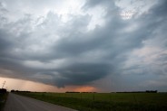
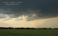
We targeted the boundary in SE KS which cut through Elk County. Mid afternoon surface data suggested a weak surface low not too far from Wichita, and convergence was pretty strong along the weak front. CAPE values were near 3000 and 500 flow was west at 40 knots, but surface winds on the north side of the boundary were very weak. We waited for initiation for quite a while near Howard, and around 6 p.m. a storm tower went up to our north. It went severe SW of Yates Center, and we caught up to it at Buffalo, west of Chanute. The base was rather high and precip-free for the most part, with a classic RFD cut and moderate wall cloud on the north side of the clear slot. The supercell cycled a few times during the approach to Chanute. On occasion a lowering with the wall cloud came about halfway to the ground, but overall rotation in the wall cloud was generally weak to moderate. Perhaps if inflow on the east side of the cell had been better, the storm would have been much better able to produce a tornado. It looked like ours tried two or three times, but it didn’t pull it off. As the storm neared Chanute, it went downhill fast and wound up with a scrawny but pretty bell-shaped updraft. We noticed that the next cell to the north had a top of 61k feet and a Doppler tornado warning, so we went NNE to catch it, near Moran and Bronson. This thing’s updraft appeared quite beastly, but then it kind of slowly weakened once we got 5 miles or so south of it. Still, the base was well organized with a very persistent wall cloud and the occasional scary appendages that were teasing the ground.
Darkness fell and I found some rooms for us in El Dorado. It was nice to see a couple of KS supercells do their darndest to tornado despite the weak surface winds.
—-
I didn’t manage any decent stills of the prominent wall cloud on the approach to the storm near Buffalo. Maybe I’ll scrounge up a video still someday.

Leave a Reply
You must be logged in to post a comment.