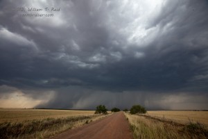
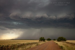
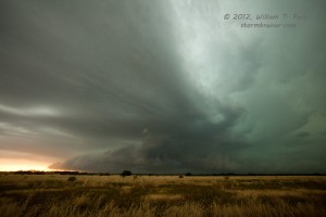
Pasted below is my CFDG account, written shortly after the chase. The chase highlight was very strong north winds out of a cell to our north, between Benjamin and Seymour (a little west of Vera, TX). At this point in time we drove beneath a little slinky funnel cloud, and one of my photos (below) suggests a funnel cloud with poor contrast. I think this photo was taken a few minutes prior to the “slinky” funnel. Perhaps 20-30 minutes later, we saw a suspicious lowering near Megargel, but there were no tornado reports with it. With regard to the funnel(s) that we saw near Vera in the strong north winds, it was my thinking at the time that the strong north winds were just due to strong, cool outflow from a precip area to our north. However, the radar did indicate a “meso” nearby, so perhaps the winds were RFD related, or RFD enhanced. The high and undercut cloud base precluded much of a tornado chance.
—-
Our tour group (with Brian M., Keith Brown, and Jon Watson) headed south from Hays into NW TX for the Memorial Day slight risk. A rather weak boundary stretched from sc OK wsw-ward towards the Midland area. CAPE along the boundary was good, up to around 3000 south of Quanah. Winds south of the boundary were weak and generally from the south. 500 flow was west at about 30 knots. So, shear and instability were adequate for severe storms, but mid-afternoon temperatures just south of the boundary were close to 100F. Very high-based storms were expected with little tornado threat.
We reached the Red River near Hollis around 4 p.m., and viewed a developing cumulonimbus about 50 miles to our SSW. This was an easy catch as the cell moved ENE and then east, towards Crowell. The high-based storm approached us south of Crowell, with a pronounced hail roar. Another large cell was about 30-40 miles to our east, but the one just to our west seemed to be winning the cloud tops derby early on. The storm split and the cyclonic member began to move more to the ESE. A rainfoot or two developed, and outflow winds threw a lot of dust and dirt around. The northerly outflow winds some 10 – 15 miles west of Seymour were particularly fierce, with plenty of dust plumes racing across the road. Threatnet showed a “wheel of fortune” above us at this point, and a well-formed but small “rat tail” funnel cloud whirled overhead from the high and ragged storm base. The storm was descending upon Seymour from the northwest, and large hail was close at hand. We continued southeast on 114.


We stopped a couple of miles west of Megargel. The storms and bases and cores seemed to be merging together to a large degree from our west to north and northeast. A lowering some five miles to our north looked very suspicious —- this looked like a good-sized funnel some 75 percent of the way down with some dirt lofted beneath. Contrast was lousy though —- It looked like a tornado for a minute or so but was a little too far away to tell for certain.
Our “Seymour” cell was really diving SE to SSE at this point—-to our west and WSW, not too far from Throckmorton. We headed to Olney and dropped south to Newcastle to try to get position on it for structure. At Newcastle we headed west about 10 miles to a south option (which heads to Breckenridge). From a point a couple of miles south of this intersection (U.S. 380 and FM 578) we had a splendid look at the base and supercell structure with fairly frequent lightning to our west. The storm was still outflow dominant, but not nearly as much as it had been. I was surprised that we were able to spend a good 10-15 minutes at this spot as the cell moved fairly slowly SSE.
Eventually we were chased south by rain and some small hail, and we made it into Breckenridge unscathed. Today was loads of fun, despite the outflowing and undercutting early on. I am anxious to see if anyone else saw the “tornado-like” item north or NNW of Megargel. It seemed odd at the time that a tornado could form given the cool outflow, but perhaps some surface inflow was sneaking in from the east side.


Leave a Reply
You must be logged in to post a comment.