
Chris Gullikson’s awesome time lapse video here.
May 26 was a very rewarding chase day for our tour group. We began the day in Grand Island, and targeted the central Nebraska area, perhaps near North Platte. SPC splashed a huge slight risk (with a 30-percent hatched hail area) from Miles City, MT, to Hill City, KS. Moisture was decent, as was wind shear, but the cap was pretty strong.
Here is the 1630Z discussion from SPC:
   ...NRN/CNTRL PLAINS THIS AFTERNOON AND TONIGHT...

   THE COLOCATION OF STEEP MIDLEVEL LAPSE RATES AND MODEST BOUNDARY
   LAYER MOISTURE CONTENT WILL COMBINE WITH DAYTIME HEATING TO YIELD A
   MODERATELY UNSTABLE AIR MASS BY AFTERNOON ALONG AND EAST OF THE LEE
   TROUGH WHERE MLCAPE VALUES WILL APPROACH 1000-1500 J/KG OVER ERN
   MT...TO AS HIGH AS 2000-3000 J/KG ACROSS PARTS OF WRN NEB INTO WRN
   AND CNTRL KS.  IN THE WAKE OF THE INITIAL ELEVATED STORMS CURRENTLY
   MOVING THROUGH THE MID-MO VALLEY...LATEST MODEL GUIDANCE SUGGESTS
   THAT SURFACE-BASED STORM DEVELOPMENT WILL BE MOST PROBABLE BY MID TO
   LATE AFTERNOON INVOF THE LEE TROUGH AND FAVORED TERRAIN OVER ERN
   PARTS OF MT AND WY...AS WELL AS TO THE NORTHEAST OF THE ERN CO LEE
   CYCLONE.  ANOTHER AREA OF POTENTIAL STORM INITIATION WILL BE ALONG
   OR JUST NORTH OF THE OUTFLOW BOUNDARY/SYNOPTIC FRONT OVER CNTRL OR
   N-CNTRL/NERN NEB LATE THIS AFTERNOON INTO EVENING WHERE
   CONVERGENCE/UPLIFT IS AUGMENTED AT THE TERMINUS OF A DEVELOPING
   LLJ.

   ELY/SELY LOW-LEVEL WINDS VEERING TO SWLY AT 25-35 KT IN THE
   MIDLEVELS WILL RESULT IN SUFFICIENT VERTICAL SHEAR FOR SUPERCELLS AS
   THE INITIAL STORM MODE.  LARGE HAIL /SOME SIGNIFICANT/ WILL BE THE
   PRIMARY HAZARD WITH THESE STORMS...THOUGH A FEW TORNADOES WILL BE
   POSSIBLE.  THIS IS ESPECIALLY THE CASE THIS EVENING OVER WRN NEB
   WHERE THE STRONGEST BUOYANCY AND DEEP-LAYER SHEAR WILL ALIGN WITH A
   CORRIDOR OF ENHANCED LOW-LEVEL SHEAR.  BY TONIGHT...STORMS MAY GROW
   UPSCALE INTO ONE OR MULTIPLE MCS/S WITH A CONTINUED RISK FOR HAIL
   AND DAMAGING WINDS SPREADING EWD INTO THE LOWER ELEVATIONS OF THE
   PLAINS.
and the 20Z update:
   ...CNTRL PLAINS AREA...

   ONLY MINOR CHANGES HAVE BEEN MADE TO THIS PORTION OF THE OUTLOOK.
   VISIBLE IMAGERY SHOW CUMULUS INCREASING ALONG N-S CONVERGENCE AXIS
   EXTENDING THROUGH WCNTRL NEB FROM A SFC LOW OVER SWRN NEB...AS WELL
   AS ALONG THE E-W QUASI-STATIONARY FRONT ACROSS CNTRL NEB. THE
   ATMOSPHERE IS BECOMING STRONGLY UNSTABLE WITH MLCAPE APPROACHING
   3000 J/KG...BUT STILL APPEARS TO BE CAPPED TO SFC BASED STORMS. AS
   THE SFC LAYER CONTINUES TO WARM...HRRR GUIDANCE INDICATE STORMS WILL
   DEVELOP OVER WCNTRL NEB BY LATE AFTERNOON. EFFECTIVE SHEAR IS
   SUFFICIENT FOR SUPERCELLS...AND 0-2 KM HODOGRAPHS WILL INCREASE IN
   SIZE AS THE LLJ STRENGTHENS DURING EARLY EVENING. VERY LARGE HAIL
   AND ISOLATED TORNADOES WILL BE THE MAIN INITIAL THREATS...BEFORE
   ACTIVITY EVOLVES INTO ONE MORE CLUSTERS LATER THIS EVENING.
Usually the best place for a chaser to hang out in anticipation of convective development is in the “backed” flow northeast of the surface low. So, we spent a lot of time in and around North Platte during the afternoon. We played frisbee and watched the sky near a park with lakes along the Interstate. Around 6 p.m., I had Steve lead the group up onto a hill south of the Interstate so that we could get a good look at the sky. FINALLY, a cluster of cumulus clouds began to look perky to our east-northeast, in eastern Custer County. That was in a great spot, with moist east-southeasterlies at the surface! We jumped onto I-80 and blasted east. It took a while for the development to really break the cap, and that was good, as it took us about an hour to get to our north option, at Elm Creek. And, it took another 30-40 minutes to reach Ansley, where a beautifully sculpted supercell was waiting for us, around 8 p.m. SPC issued a mesoscale discussion for our area of interest at 6:55 p.m., replete with a detailed surface map:
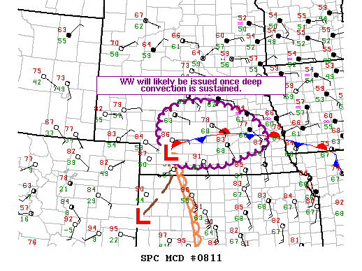
   MESOSCALE DISCUSSION 0811
   NWS STORM PREDICTION CENTER NORMAN OK
   0655 PM CDT SUN MAY 26 2013

   AREAS AFFECTED...CNTRL NEB

   CONCERNING...SEVERE POTENTIAL...WATCH LIKELY

   VALID 262355Z - 270200Z

   PROBABILITY OF WATCH ISSUANCE...80 PERCENT

   SUMMARY...TSTM INITIATION MAY OCCUR BETWEEN 00-01Z ALONG THE
   QUASI-STATIONARY FRONT ACROSS CNTRL NEB. ONCE INITIATION APPEARS
   IMMINENT...A WW WILL LIKELY BE ISSUED.

   DISCUSSION...SURFACE QUASI-STATIONARY FRONT EXTENDED FROM NEAR LBF
   TO OMA AS OF 23Z. INCREASINGLY AGITATED CU HAVE BEEN NOTED IN
   VISIBLE SATELLITE IMAGERY...BOTH ALONG THE BOUNDARY OVER CUSTER
   COUNTY AND FARTHER N FROM CHERRY TO GARFIELD COUNTIES. RELATIVELY
   GREATER SURFACE PRESSURE FALLS ARE CONCENTRATED IN S-CNTRL NEB AND
   GIVEN THE STRONGLY UNSTABLE AIR MASS S OF THE FRONT...ONCE DEEP
   CONVECTION IS SUSTAINED...RAPID GROWTH INTO SUPERCELLS IS LIKELY.
   EVEN IF TSTMS DO NOT BECOME SUSTAINED NEAR-TERM...MORE WIDESPREAD
   DEVELOPMENT IS ANTICIPATED LATER IN THE EVENING AS THE LLJ
   INTENSIFIES.

   SUFFICIENT LOW-LEVEL SRH WILL EXIST FOR A TORNADO THREAT FOR A FEW
   HOURS UNTIL LATE EVENING. OTHERWISE...LARGE HAIL AND SEVERE WIND
   GUSTS WILL BE THE LONGER-DURATION HAZARDS.

   ..GRAMS/THOMPSON.. 05/26/2013
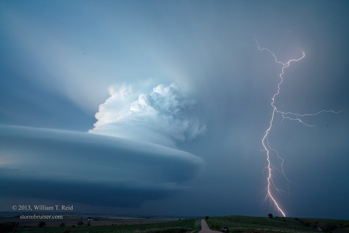
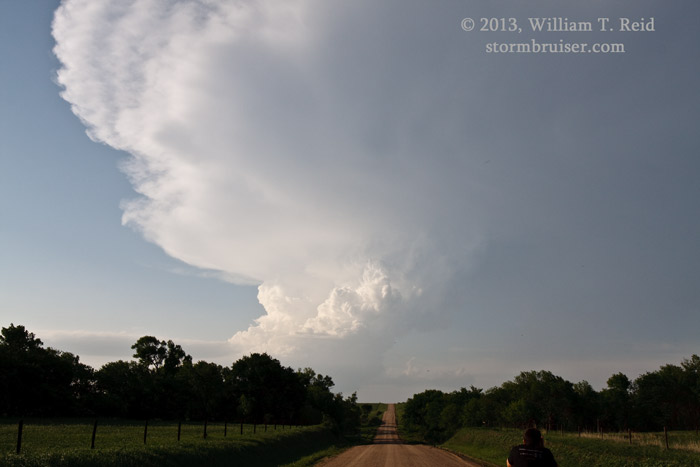
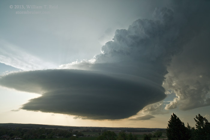
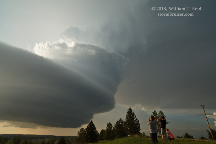
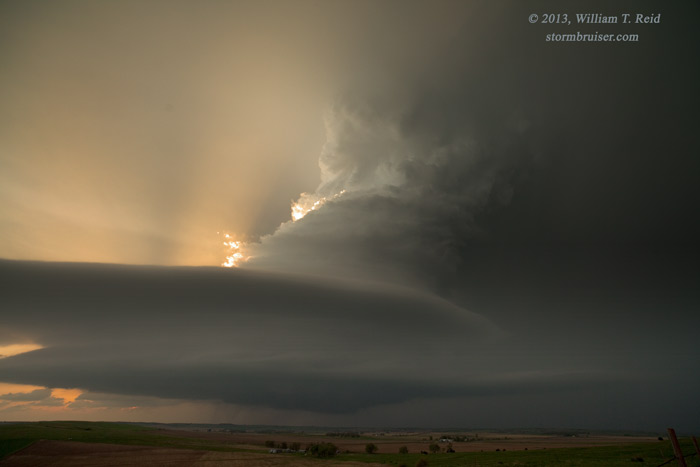
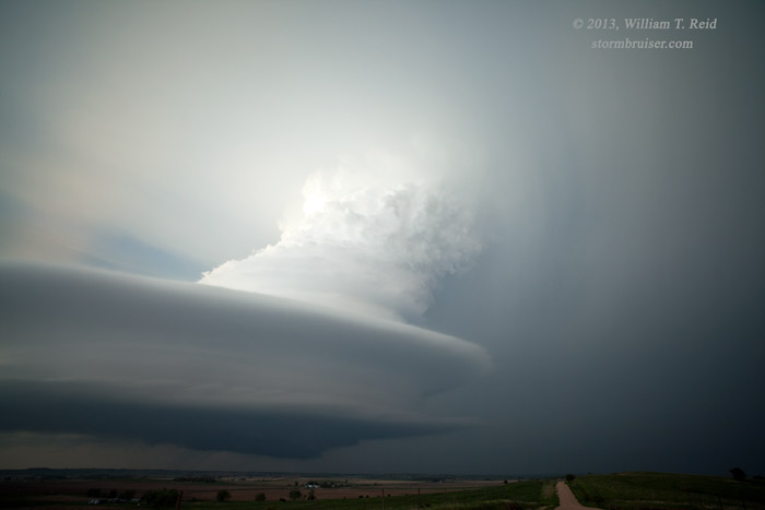
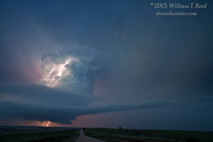
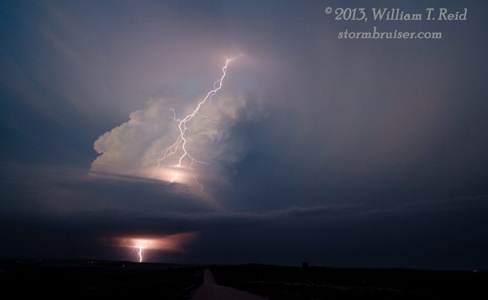
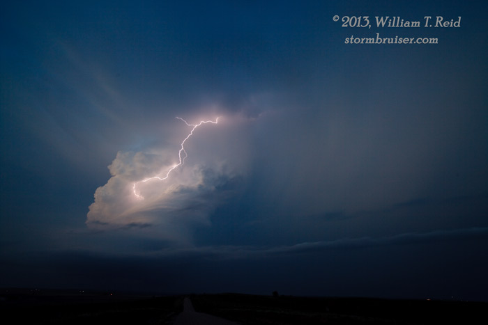
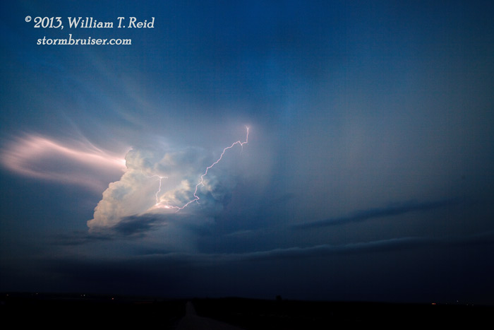
We spent some time along a driveway on a hill in Ansley, as the updraft loomed to our northwest, and then north. The base was rather high, and tornado prospects appeared slim for the time being. It was a good spot to get some time-lapse of the structure. Here are some looks as we approached from the south along U.S. 183 and from Ansley. The final one of the six below (3461) was at 8:00 p.m.

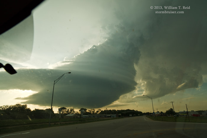
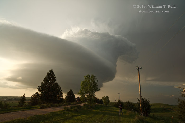
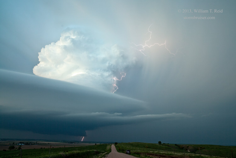
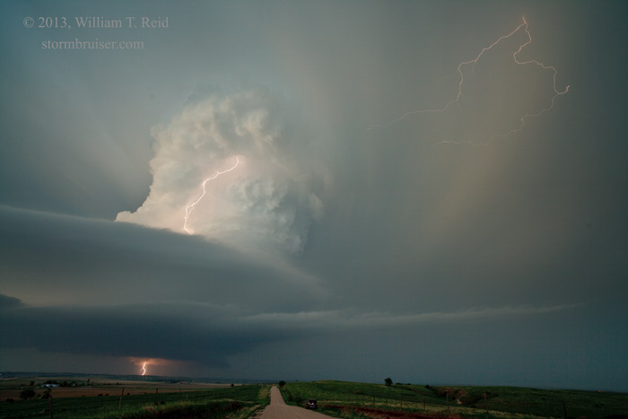
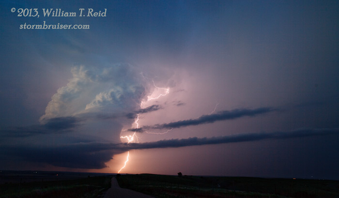
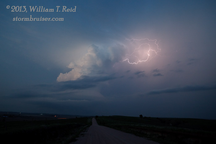
The storm had been moving north to northeast, but was now slowing down and turning more to the right. I had the option of heading seven miles north to our next east option, but that put us beneath the base and likely into some very large hail. Since the tornado prospects appeared minimal, I opted for the “structure” positioning alternative. We headed east on 92 about ten miles, to a north option just one mile east of the Custer/Sherman county line, and then scooted another six miles or so to the north. This worked out really well, as we were afforded a magnificent view of the supercell to our west-northwest! All we had to do now was to stick the cameras and camcorders onto the tripods and enjoy the show. Occasional CGs out of the anvil were breathtaking, especially towards dusk as the base moved north of our location. The storm dropped 3-inch hail on Westerville, north of Ansley, so it is probably good that I didn’t try going north out of Ansley!
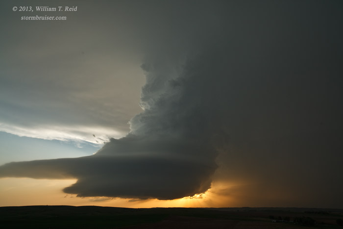
As darkness fell and the cell weakened, we went west on 70 to Westerville to look at a new severe storm to our northwest. The lightning was frequent, but the activity was starting to get messy, and it was time to head south to our motel in Cozad.


Leave a Reply
You must be logged in to post a comment.