Following our long chase day yesterday across South Dakota, we awoke in Lemmon, SD, with another rather lengthy drive ahead of us. There was a slight risk for severe storms forecast for much of southeastern South Dakota, with a 10 percent tornado area centered around Wessington Springs, SD. We set our sights on the I-90 area from about Kimball to Mitchell —- about 300 driving miles distant.
After a quick lunch in Gettysburg, we observed some strong convection not too far to our west, along the Missouri River. I decided to head about 15 miles west to take a look, but this stuff was elevated and moving towards areas with persistent cloud cover. I figured that there was a chance that this activity might eventually become surface-based with a tornado risk, but the better play still seemed to be farther to the southeast. As we motored south from about Highmore to Fort Thompson, additional storms developed near and a little to the west of the Missouri River, around Chamberlain. These seemed to be linear, high-based, and were not in the “good air.” I ignored them and continued to Kimball. We waited around Kimball for about two hours in the hot and humid air mass, with one eye on the junky stuff to our west and northwest, and one eye on the somewhat perky cu field in our vicinity, in the “good” air. If a storm could break the cap and explode in this high-CAPE air with the great low-level shear, then we would be in Fat City! Despite the great low-level convergence, the cap proved to be too strong near, south and east of Kimball. A mesoscale discussion issued around 3:30 p.m. by SPC offered optimism, however:
 MESOSCALE DISCUSSION 1065
   NWS STORM PREDICTION CENTER NORMAN OK
   0329 PM CDT WED JUN 18 2014

   AREAS AFFECTED...SERN SD/NERN NEB AND VICINITY

   CONCERNING...SEVERE POTENTIAL...TORNADO WATCH LIKELY

   VALID 182029Z - 182200Z

   PROBABILITY OF WATCH ISSUANCE...80 PERCENT

   SUMMARY...SEVERE/TORNADO RISK IS GRADUALLY INCREASING ATTM ACROSS
   THE DISCUSSION AREA...WITH TORNADO WATCH ISSUANCE POSSIBLE.

   DISCUSSION...LATEST VISIBLE SATELLITE IMAGERY SHOWS A GRADUALLY
   INCREASING/DEEPENING CU FIELD ACROSS SERN SD AND ADJACENT NRN
   NEB...NEAR AND E OF A SURFACE LOW ANALYZED E OF ANW ATTM.  A MOIST
   BOUNDARY LAYER INVOF THE LOW AND THE ASSOCIATED/ESEWD-ALIGNED WARM
   FRONT HAS BECOME STRONGLY UNSTABLE WITH AFTERNOON HEATING...WITH
   MIXED-LAYER CAPE IN EXCESS OF 4000 J/KG INDICATED.

   THE DEGREE OF INSTABILITY COMBINED WITH LOW-LEVEL SELY FLOW VEERING
   TO SWLY WITH HEIGHT AND INCREASING TO 30-40 KT AT MID LEVELS IS
   YIELDING AN ENVIRONMENT QUITE SUPPORTIVE OF SUPERCELLS -- AND
   ASSOCIATED SEVERE/TORNADO POTENTIAL.  WE WILL CONTINUE TO MONITOR
   EVOLUTION OF THE CU FIELD ACROSS THIS REGION FOR TIMING OF POSSIBLE
   WW ISSUANCE.

   ..GOSS/MEAD.. 06/18/2014
As the clock ticked a little past 6 p.m. CDT, and with the favored area floundering, I figured that it was time to take another look at the line of convection to our northwest. We made one final pit stop in Kimball, and then learned of a tornado report with the line, about 40 miles to our northwest. All we had to do was drive north on Route 45 about 20 miles, to Gann Valley, and we would be in decent position!
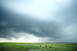
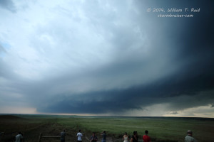
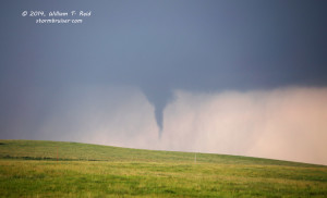
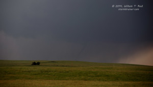
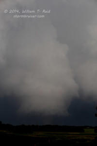
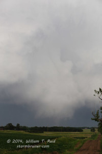
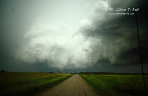
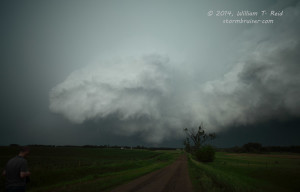
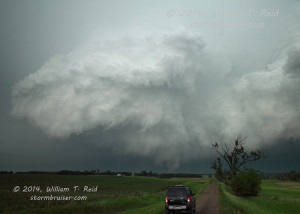
From near Gann Valley, SD, we observed a somewhat interesting swath of “storm” from our southwest to west to northwest. This did not appear to be activity with good tornado potential, though there was some low-level banding, some indications that there were individual discrete updrafts, and storm bases with RFD cuts. The images above were taken about 6:30 p.m. I was a little dubious about the previous tornado report, but a little later a rather nondescript storm base was wrapping up and planting a tornado, perhaps five to seven miles to our southwest. Okay, okay, I believe now!
This tornado, near Gann Valley, was photographed from about 6:55 to 7 :00 p.m. and it quickly became wrapped in rain. We were a couple of miles east of the intersection of 45/34 in Buffalo County, and the tornado was to our southwest. Frequent CG activity nearby forced us back into the vans. Where to go now…wait around here and watch the rain-wrapped area? I was reluctant to head west again and possibly put myself out of position for bigger and better stuff later, and there didn’t seem to be much to look at once the tornado disappeared. We headed east on 34 into Jerauld County to maintain position. The problem for me was that I really didn’t know where good position was! On the radar and visually, the storm activity looked more like linear junk than supercells. Paved road options in this part of the world were few, and I continued all of the way east past Wessington Springs to U.S. 281. There were new strong towers to our south, and I figured that our next best chance might be with that.
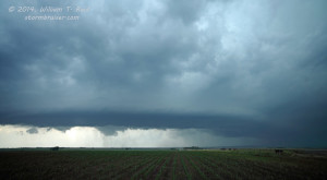
From Route 34 and U.S. 281, we dropped south six miles and set up. To our west was the cell that produced the Gann Valley tornado, and now it looked more like a supercell, with a large and well-organized RFD cut and a precipitation-filled action area to our west-northwest. This presumably was the tornado which struck Wessington Springs. During this time frame, we did not observe a tornado and we were unaware of one in progress. The images above are of the Wessington Springs tornadic storm, looking west to WNW, around 7:30 to 7:35 p.m. Lightning activity again increased nearby, and we had to get back into the vans. I directed the drivers southward a little, as a new area of low-level rotation was just to our south. After just a mile and a half we were observing a little tornado that was only a tenth of a mile to our southeast. This was a rapidly rotating and dusty whirl without a condensation funnel, beneath a well-developed rotating wall cloud. We stopped to watch as the tornado moved north, just west of U.S. 281. It dissipated quickly, but we were treated to an impressive funnel cloud and wild rotation overhead!
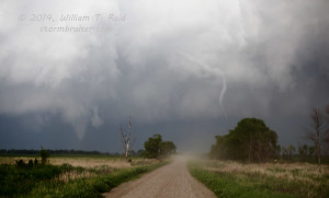
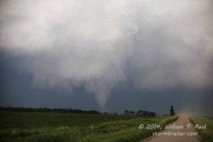
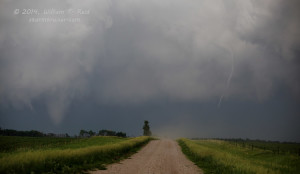
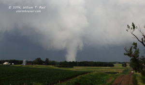
This impressive action area moved off to our north, and it was time to catch up to it. We went north a half mile to 236th Street, and I elected to turn east here (the road to Twin Lakes), as I thought that the storm was moving more to the northeast than the north. Soon a good-sized tornado was developing out of the wall cloud to our north! We continued to the east and desperately needed to find a decent road to the north! After three or four miles we turned north on an unpaved but relatively reasonable road. The tornado appeared to be a good 5 to 6 miles to our north already, though —- it seemed like the storm was accelerating northward and doing whatever it took to get away from us. Shoot — we had been in such great position at one point, and now we are playing catch-up on slightly wet dirt roads — this is not what I wanted. As we blasted northward as best we could, a solid and strong tornado was in progress to our N to NNW, to the left of our N-S road. And, a second skinny and ropy tornado was to the right of this one, on the right side of our road!
These are looking north around 7:45 to 7:50 p.m. CDT. We went north a few more miles, still south of Route 34, and stopped again for pictures and video. I managed to get some zoomed-in shots of the tornado and some wide-angle views with the 21mm lens.
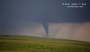
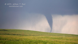
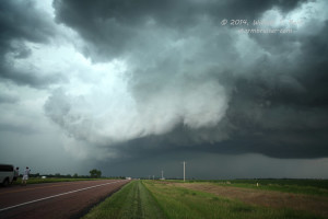
The images above were taken around 8:05 to 8:08 p.m. CDT. The look into the RFD cut of the storm updraft with the tornado was impressive and wicked, as you can see! This was our last good look at the tornado as it continued rather quickly to the north. As we neared Route 34, between Lane and Woonsocket, we passed some trees and farm equipment which had just sustained wind damage — most likely from the slender/ropy tornado.
We went east on 34 and then north on 37, northeast of Woonsocket, and got a good look at our tornadic supercell to our WNW. It never got serious about making another tornado, though, and was weakening rather quickly.
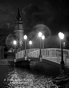
Back in Woonsocket, I reserved rooms for the group in Plankington, and managed to get some stills of the pretty sunset near a lake and a church in town.
















Leave a Reply
You must be logged in to post a comment.