

May 6 was a big tornado day for the central and southern Great Plains. The SPC log shows 59 tornados. Our Tempest Tours chase group began the day in Lubbock, and we targeted the area to the east a few counties away. Supercell and tornado prospects looked quite good in the area around Seymour, TX. We went after early afternoon convection in northwest TX during the afternoon, but it was junky and unrewarding. There were too many storms, as mentioned in a mesoscale discussion:
 MESOSCALE DISCUSSION 0515
   NWS STORM PREDICTION CENTER NORMAN OK
   0103 PM CDT WED MAY 06 2015

   AREAS AFFECTED...PORTIONS OF WEST TEXAS...NORTHWEST TEXAS AND
   SOUTHWEST OKLAHOMA

   CONCERNING...SEVERE POTENTIAL...WATCH LIKELY

   VALID 061803Z - 062000Z

   PROBABILITY OF WATCH ISSUANCE...95 PERCENT

   SUMMARY...THUNDERSTORMS EXPECTED TO DEVELOP RAPIDLY BETWEEN 18 AND
   19Z. SEVERE HAIL AND WIND GUSTS ARE THE PRIMARY THREATS
   INITIALLY...BUT TURNING LOW-LEVEL HODOGRAPHS SUGGEST A TORNADO
   THREAT FOR ANY SUSTAINED UPDRAFTS.

   DISCUSSION...STRONG HEATING HAS CONTRIBUTED TO RAPID DESTABILIZATION
   AHEAD OF A DIFFUSE DRYLINE WITH AN EASTERN EDGE STRETCHING FROM EAST
   OF LBB TO NEAR SHAMROCK.  ALTHOUGH THE MCD AREA IS UNDER NEUTRAL TO
   SLIGHT MID-LEVEL HEIGHT RISES IN THE WAKE OF THE EXITING
   WAVE...LITTLE TO NO CONVECTIVE INHIBITION IS PRESENT OVER THE AREA.
   MIXED-LAYER CAPE VALUES HAVE RISEN ABOVE 2000 J/KG WITH LOW-LEVEL
   LAPSE RATES ABOVE 8 C/KM. WITH EFFECTIVE SHEAR OF 30-40
   KT...SUPERCELL STRUCTURES WILL BE THE FAVORED MODE FOR PERSISTENT
   UPDRAFTS...BUT LONGEVITY OF THE SUPERCELLS COULD BE NEGATIVELY
   IMPACTED BY STORM INTERACTIONS AS NUMEROUS STORMS ARE EXPECTED TO
   DEVELOP UNDER LITTLE INHIBITION AND POSSIBLY ENHANCED BY LIFT FROM A
   WEAK POTENTIAL VORTICITY ANOMALY PROGRESSING THROUGH THE BROAD
   CYCLONIC FLOW IN UPPER-LEVELS.  REGARDLESS OF STORM MODE...SEVERE
   HAIL IS LIKELY WITH THE STRONGER STORMS...WITH SEVERE WIND GUSTS
   POSSIBLE GIVEN THE STEEP LOW-LEVEL LAPSE RATES. ALTHOUGH LOW-LEVEL
   WIND SPEEDS REMAIN SOMEWHAT MODEST...LOW-LEVEL HODOGRAPHS SHOW
   CURVATURE...WITH EFFECTIVE HELICITY VALUES OF 100-150 M2/S2 FOR
   STORMS THAT DEVIATE TO THE RIGHT OF THE MEAN FLOW AND SHEAR.

   ..CONIGLIO/HART.. 05/06/2015
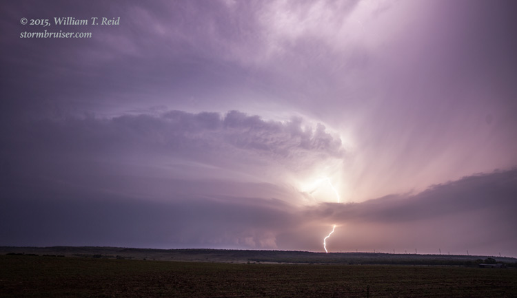
Early convection seemed to be a theme this May on the Southern Plains. About an hour before sunset, a new storm developed WSW of Throckmorton by about 20 miles. This one looked to be in a good spot, which had not been worked over by previous convection and which had an unobstructed feed of juicy Gulf air. The storm was very slow to move as we approached from the east on U.S. 380, west of Throckmorton. We had a good look at the base, which was just south of 380, but we were hesitant to get too close via 380 due to large hail prospects just up the road.

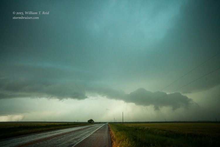
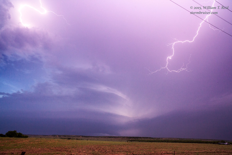
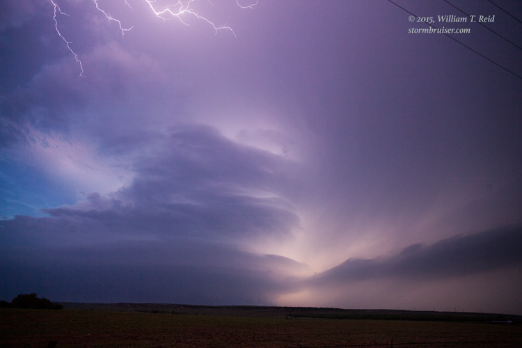
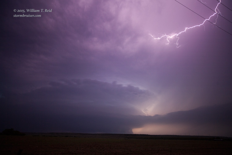
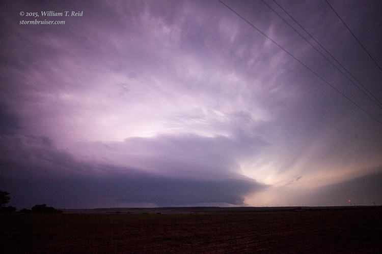
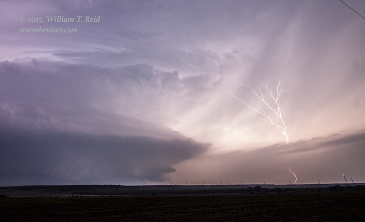
The road network here is poor, and there was no way to get up close to the base without driving off of the pavement or sampling the hail core. The sun set soon after the images above were taken, and the storm continued to drift to the east. The base refused to come up to the north along U.S. 380, so I decided to go into structure-viewing mode. We headed back east to Throckmorton (about 10 miles) and then dropped south on 183/283 approximately 6 miles. Here we had a great view of the supercell, and we had plenty of time to set up for lightning photography at dusk and beyond. The storm was quite electrified, with occasional spider lightning in the anvil overhead. Around 9:30 p.m., chasers that were closer to the base (near Throckmorton) observed a large tornado with the storm. The tornado crossed U.S. 380 near Highway 222, about 6 miles west of Throckmorton, and became rain-wrapped. The tornado was not observed by anyone in our group, perhaps because there was a very slight rise in the terrain to our northwest. Bummer. I had reserved rooms in Vernon, about an hour to our north. We had to wait about an hour for the slow-moving supercell to clear the road and move off to the east before heading north out of Throckmorton County. Here is a sampling of my wide-angle shots, taken south of Throckmorton and looking mostly to the northwest (the road and power poles head to the north). Images 0329 and 0333 below were taken about the time of the tornado reports.


Leave a Reply
You must be logged in to post a comment.