
Video of this event by Tempest guide Chris Gullikson
This was the fifth chase day for the folks on 11-day Tour 3, and it was looking like our first decent chance for a tornado. SPC had an “enhanced” slight risk splattered over the Nebraska Panhandle, and a 5 percent tornado risk outlined. Here is their discussion from the Day One outlook at 1630Z (10:30 a.m. MDT):
 .PREV DISCUSSION... /ISSUED 1130 AM CDT FRI MAY 15 2015/

   ...CENTRAL HIGH PLAINS THIS AFTERNOON INTO TONIGHT...
   A LARGE-SCALE TROUGH OVER THE SRN GREAT BASIN WILL PROGRESS SLOWLY
   EWD WHILE DOWNSTREAM RIDGING ALOFT PERSISTS OVER THE MS/OH VALLEY
   REGION.  A SERIES OF EMBEDDED SPEED MAXIMA WILL ROTATE EWD AND NWD
   AROUND THE ERN PERIPHERY OF THE TROUGH...WITH ONE SUBTLE SPEED MAX
   TRANSLATING NNEWD OVER CO...AND A STRONGER UPSTREAM WAVE OVER NRN
   BAJA CA THAT WILL REACH THE SRN HIGH PLAINS LATE TONIGHT.  AT THE
   SURFACE...A LEE CYCLONE WILL CONTINUE TO DEEPEN SOME THROUGH THE
   AFTERNOON ACROSS NE CO...AND A WARM FRONT WILL MOVE NWD INTO NEB.
   THE MOISTURE PATTERN IN THE LOW LEVELS HAS BEEN DISRUPTED BY THE
   EFFECTS OF OVERNIGHT CONVECTION ACROSS KS/OK...WITH SUBSTANTIAL
   DRYING NOTED ACROSS WRN KS.  THIS DRIER LOW-LEVEL AIR WILL SPREAD
   NWD INTO SW NEB TODAY AND WILL TEND TO OFFSET DESTABILIZATION DUE TO
   DAYTIME HEATING...WHILE SOMEWHAT HIGHER DEWPOINTS WILL BE MAINTAINED
   FROM SE NEB INTO ERN KS WHERE SURFACE TEMPERATURES WILL BE SLOWER TO
   WARM AS A RESULT OF LINGER CLOUDS/CONVECTION.

   AS THE SPEED MAX MOVES NNEWD OVER CO...THUNDERSTORM DEVELOPMENT IS
   EXPECTED NEAR AND N OF THE LEE CYCLONE BY EARLY-MID AFTERNOON FROM
   N/NE CO INTO SE WY AND THE NEB PANHANDLE.  BOUNDARY LAYER DEWPOINTS
   IN THE LOW-MID 50S AND SURFACE TEMPERATURES WARMING INTO THE
   70S...BENEATH STEEP MIDLEVEL LAPSE RATES...WILL RESULT IN MODERATE
   BUOYANCY THIS AFTERNOON /MLCAPE VALUES APPROACHING 2000 J PER KG/.
   COINCIDENT WITH THE DESTABILIZATION...DEEP-LAYER VERTICAL SHEAR WILL
   BECOME FAVORABLE FOR SUPERCELLS CAPABLE OF PRODUCING LARGE HAIL AND
   DAMAGING WINDS.  SOME UPSCALE GROWTH INTO CLUSTERS/LINE SEGMENTS
   WILL BE POSSIBLE BY THIS EVENING AS STORMS OVERSPREAD SW SD.
   LOW-LEVEL SHEAR AND MOISTURE WILL BE SUFFICIENT FOR A COUPLE OF
   TORNADOES WITH THE MORE DISCRETE SUPERCELLS LATER THIS AFTERNOON.
I figured that we would want to be on a storm along the warm front which was lifting northward through the Panhandle. Winds were coolish, moist and from the east on the north side of the front, and tornadoes like that sort of environment — if there is sufficient daytime sunshine to warm that sector a bit. Models such as the HRRR were showing good tornado “numbers” in Cherry County and the northern Nebraska Panhandle towards sunset, along the front. I did not want to get side-tracked by something else which might drag me too far away from that target area. We headed north from Burlington and had lunch at Runza in Sidney. Storms started to go up near the Cheyenne Ridge in the early afternoon. What is it with all of the early development this month?! SPC had a new mesoscale discussion for us, with a nice map to peruse.
  MESOSCALE DISCUSSION 0646
   NWS STORM PREDICTION CENTER NORMAN OK
   0114 PM CDT FRI MAY 15 2015

   AREAS AFFECTED...WRN NEB...SERN WY AND NERN CO

   CONCERNING...SEVERE POTENTIAL...WATCH LIKELY

   VALID 151814Z - 152015Z

   PROBABILITY OF WATCH ISSUANCE...80 PERCENT

   SUMMARY...STORMS ARE EXPECTED TO DEVELOP THIS AFTERNOON FROM NERN CO
   INTO WRN NEB AND SERN WY. SUPERCELLS WITH LARGE HAIL WILL BE THE
   MAIN THREAT...BUT DAMAGING WIND AND FEW TORNADOES WILL ALSO BE
   POSSIBLE.

   DISCUSSION...EARLY THIS AFTERNOON A WARM FRONT EXTENDS FROM A SFC
   LOW IN NERN CO THROUGH SWRN NEB AND EWD THROUGH SERN NEB. DRYLINE
   EXTENDS SWD FROM THE LOW THROUGH ERN CO. MORNING CONVECTION HAS
   DISSIPATED...AND RESIDUAL CLOUDS HAVE SHIFTED NORTH OF WARM FRONT
   OVER MUCH OF THIS REGION. THUS STRONG DIABATIC WARMING WILL RESULT
   IN DESTABILIZATION OF THE WARM SECTOR WHERE DEWPOINTS ARE CURRENTLY
   IN THE MID 50S AND STEEP MID LEVEL LAPSE RATES ARE IN PLACE. MLCAPE
   SHOULD INCREASE TO AROUND 1500-2000 J/KG. TRENDS IN SATELLITE
   IMAGERY INDICATE BELT OF DEEPER ASCENT ACCOMPANYING A NEWD EJECTING
   SHORTWAVE TROUGH IS ALREADY SPREADING THROUGH NCNTRL CO AND SCNTRL
   WY. AS THIS FORCING INTERACTS WITH DESTABILIZING BOUNDARY
   LAYER...STORMS ARE EXPECTED TO DEVELOP INITIALLY OVER NERN CO THEN
   FARTHER NEWD ALONG DRYLINE AND WARM FRONT. DEEP SHEAR PROFILES FROM
   35-40 KT WILL SUPPORT ORGANIZED STORMS INCLUDING SUPERCELLS.

   ..DIAL/THOMPSON.. 05/15/2015
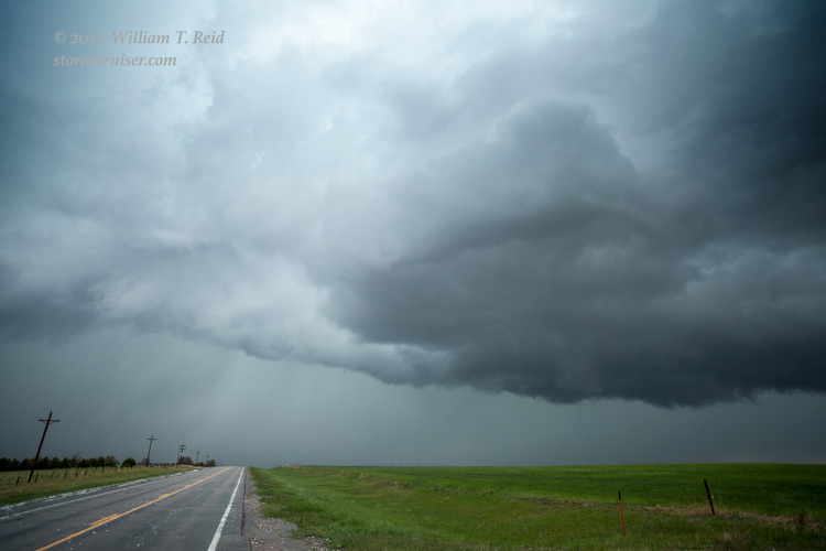
We latched onto a cell that was moving north, on the west and northwest side of Sidney. This one became supercellular, with a rounded base and a decent lowering from time-to-time. A tornado even seemed possible from this storm, and we needed to stay with it!
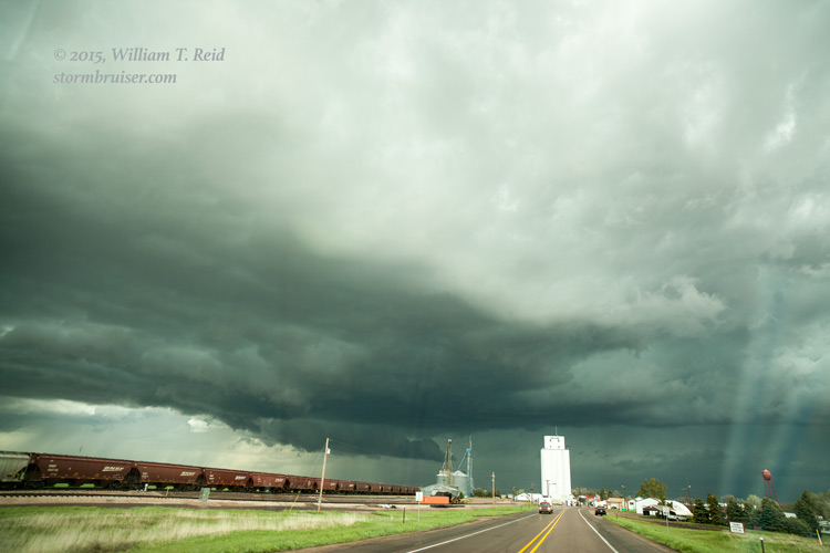
It was moving north through a rather poor road network. We would have liked to have stayed close on the east side, looking at it to the west, but U.S. 385 to Bridgeport makes a hard turn to the WNW. I decided that being ahead of the storm was better than being behind it, so we braved the hail and continued to Angora and then northeast to Alliance. This put us well ahead of our supercell, which was now having problems and looking less organized. Meanwhile, another updraft was apparent to our east and was moving towards Alliance. We stayed near this one, with a view of its updraft base to our east and then northeast, from Alliance to almost Hay Springs. The storm was moving to the NNW, and precip eventually obscured our good view of the storm base.
SPC issued another mesoscale discussion about this time, regarding the tornado watch which covered the Nebraska Panhandle:
MESOSCALE DISCUSSION 0651
   NWS STORM PREDICTION CENTER NORMAN OK
   0628 PM CDT FRI MAY 15 2015

   AREAS AFFECTED...NERN CO...SERN WY...NEBRASKA PANHANDLE

   CONCERNING...TORNADO WATCH 172...

   VALID 152328Z - 160030Z

   THE SEVERE WEATHER THREAT FOR TORNADO WATCH 172 CONTINUES.

   SUMMARY...TORNADO THREAT CONTINUES WITH SUPERCELLS OVER WW172.

   DISCUSSION...NUMEROUS SUPERCELLS CONTINUE ACROSS THE NEBRASKA
   PANHANDLE THIS EVENING WITH A TENDENCY TOWARD CLUSTERING ACROSS NRN
   PORTIONS OF WW.  LLJ SHOULD INCREASE OVER THE NEXT FEW HOURS INTO
   THIS ACTIVITY WHICH SHOULD AID FURTHER EXPANSION OF THIS COMPLEX OF
   STORMS.  LARGE HAIL WILL BE COMMON WITH SUPERCELLS ALONG WITH
   ISOLATED TORNADOES.

   ..DARROW.. 05/15/2015
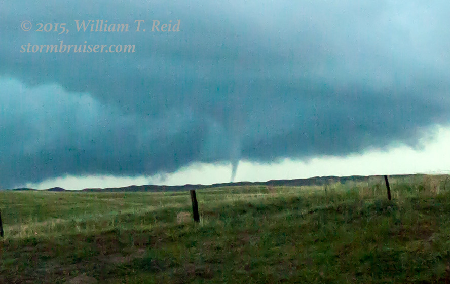
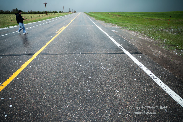
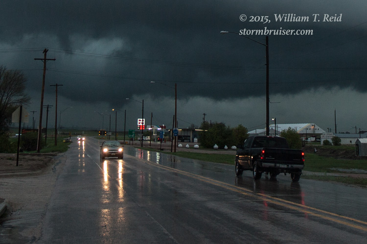
The “Alliance-to-Hay Springs” supercell was dropping some large hailstones, with a baseball-size hail report nearby. We came up on plenty of golfball-sized stones some 15 miles or so south of Hay Springs. Well, our storm looked okay on radar, but visually we just didn’t have a good sense of what was happening. We stopped in Hay Springs for a quick pit stop, and when I stepped out of the convenience store and looked to the west, towards the supercell, I could see a “little” cone-shaped tornado in the distance! I yelled at everyone to take a look to the west and tried to get some images, but the tornado was gone pretty quickly. In any event, it looked like the warm front was working its magic, as we had some nice easterly winds here! These two pics were taken a minute or two after the tornado, and the second one is a cropped version showing the area that was tornadic. This was close to 7 p.m. MDT.

We drove WNW several miles on U.S. 20 to check out the storm again, but it was looking mushy and less organized. With about an hour of decent daylight remaining —- what to do now?! Well, there was no point in giving up on the day yet. NOW was the time when tornado potential was forecast to be highest! And, we were in our target area. We just needed another storm. I looked at the radar, and there it was —- a nice, compact, small and discrete cell was moving north through the Sand Hills to our southeast. I don’t think it was warned for anything, as it looked rather unimposing on radar. But, it was an easy intercept as we had rooms booked in Valentine (about two hours to our east) and we could watch the storm approach as we waited along U.S. 20. We scooted to the east and stopped about ten miles east of Gordon, NE. The little supercell was coming directly at us from the south. We were at a driveway gate to the “Johnson” ranch (“Rod and Donna Johnson” according to the welcome sign!) along U.S. 20, a little east of the Sheridan/Cherry county border, on the Cherry County side.
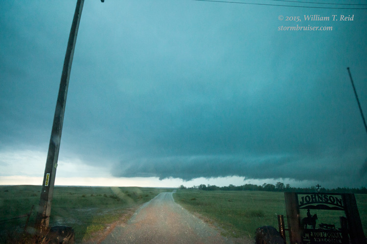
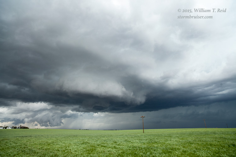
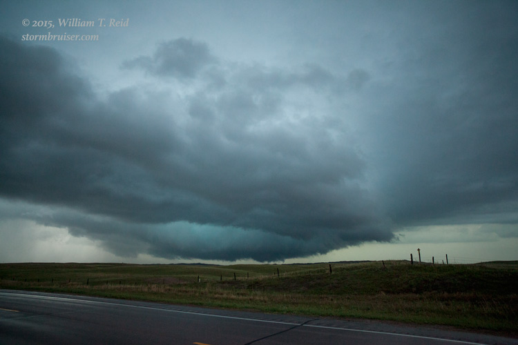
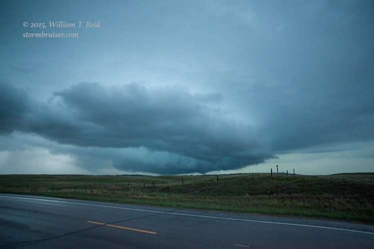
We stayed in the vans due to some rain and lightning in the vicinity. The view to the south (above, around 8:20 p.m. MDT) showed a nice, roundish base. A little later (second photo above) a shallow wall cloud had developed. It looked like the cell was moving slightly west of due north, and the base would soon be just to our southwest and west.
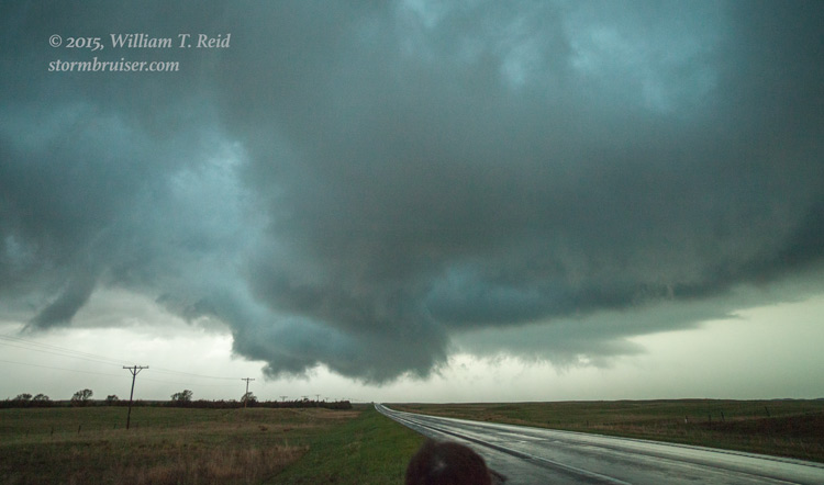
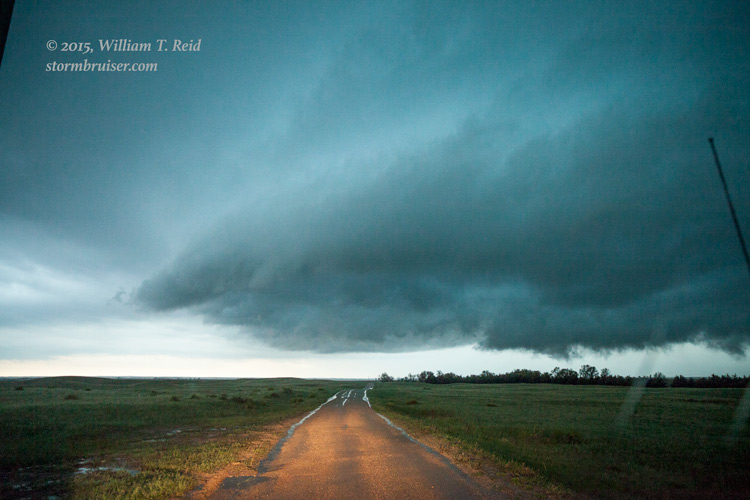
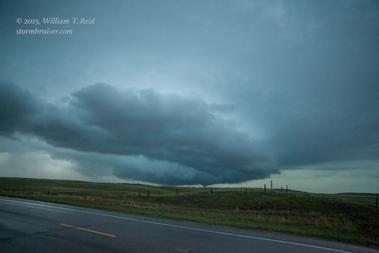
At 8:28 p.m. MDT (above), a prominent lowering was just down U.S. 20 to our west, and we were outside of the vans with our eyes glued on the storm base. It was moving rather rapidly from left to right, and though it was after sunset now and getting a little dark, the contrast was pretty good. To our delight, the storm went tornadic a couple of minutes later to our north-northwest!
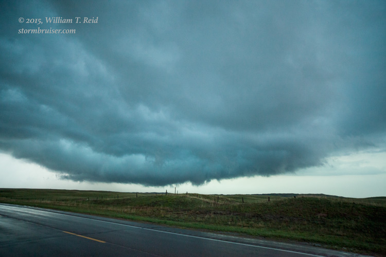
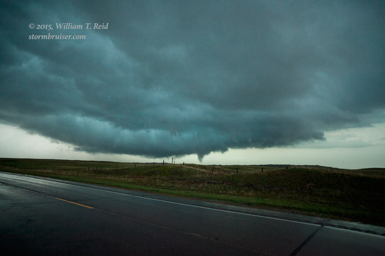

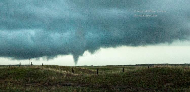
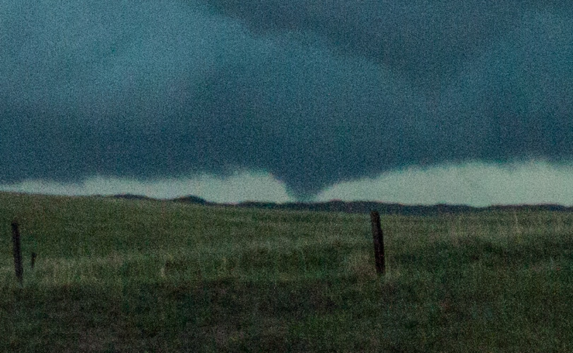
I managed a few photos with the wide-angle lens (some images here are heavily cropped). I believe there were two separate tornadoes from 8:32 to 8:37 p.m. MDT, or the same circulation “lifted” and then touched down again. It was getting dark fast and the storm was moving away from us, maybe 4 to 6 miles distant. These images suggest that there was a tornado on the “backside” of the “backwards C-shaped” updraft base, from our perspective, and there was also a tornado on the “near-side” of the updraft base.


I phoned the NWS in North Platte to let them know about the tornadoes, but they didn’t seem to believe me! There were no other vehicles nearby, but apparently another chaser or “official” also witnessed the activity. I think we were about four miles east of the Sheridan/Cherry county line, and that the tornadoes were on the Cherry County side, barely. The storm was moving over an uninhabited area of rangeland and sandhills, and I do not know if the storm continued tornadic as it crossed into South Dakota, just 15 miles to our north. For me, it was time to get the happy group of chasers to their beds in Valentine.
Leave a Reply
You must be logged in to post a comment.