
Quick — is Kanorado in Kansas or Colorado? That’s right, it’s in Kansas. The supercell that we intercepted on this chase day was in Colorado, however. It moved to the south, just west of the KS/CO border. It was close enough to Kansas along I-70 to drop half-dollar-sized hail on Kanorado.
It took a good deal of the daylight hours, and daylight minutes, for that matter, to reach this storm. This was the arrival day for the Tour 5 group, including Tempest guides Chuck Doswell, Tom Trott, and Woody Watson. We did a quick-and-dirty orientation for the new guests at the hotel in Oklahoma City, and then hit the road. I figured that I needed to be in extreme western Kansas by late afternoon. I briefly considered I-40 west and the Northwest Passage to Woodward and Garden City, but stuck to the I-35 north/I-70 west option.
So, what was the setup like?
SPC showed only a marginal risk of severe weather along the KS/CO border, with a 2 percent tornado risk outlined. The 1630Z Day One discussion was decidedly less than awesome:
   ...HIGH PLAINS THIS AFTERNOON AND EVENING...

   AS MENTIONED IN THE SYNOPSIS...MID-LEVEL HEIGHTS WILL RISE TODAY
   WITH PERHAPS A WEAK PERTURBATION OR TWO CRESTING THE BUILDING RIDGE
   AXIS OVER THE NRN INTER-MOUNTAIN REGION INTO NRN HIGH PLAINS.
   MOREOVER...12Z RAOBS INDICATED RELATIVELY DRY BOUNDARY-LAYER
   CONDITIONS WHICH WILL LIMIT THE DEGREE OF AFTERNOON DESTABILIZATION.
   WHILE THESE FACTORS WILL LIKELY PRECLUDE THE DEVELOPMENT OF AN
   ORGANIZED SEVERE WEATHER EPISODE...ISOLATED OCCURRENCES OF WIND AND
   HAIL MAY OCCUR WITH STRONGER STORMS FORMING ALONG THE HIGH TERRAIN
   AND/OR LEE TROUGH LATER THIS AFTERNOON INTO EVENING.
Naturally, I downplayed the chase prospects to the group, but noted that there was an outside chance of a decent, isolated storm. We had a fast-food lunch at Park City, KS, and continued north to Salina and then west across Kansas in I-70. As we blew through Hays and Oakley, deep moist convection initiated to our WNW, northwest of St. Francis, KS. Perfect! If this could hold together for a few hours, then we might have a fun chase. SPC even chimed in with a mesoscale discussion just before 3 p.m. MDT:
   MESOSCALE DISCUSSION 0852
   NWS STORM PREDICTION CENTER NORMAN OK
   0350 PM CDT SUN MAY 31 2015

   AREAS AFFECTED...ERN CO...WRN KS...EXTREME SWRN NEB

   CONCERNING...SEVERE POTENTIAL...WATCH UNLIKELY

   VALID 312050Z - 312245Z

   PROBABILITY OF WATCH ISSUANCE...20 PERCENT

   SUMMARY...ISOLATED SEVERE THUNDERSTORMS ARE POSSIBLE THIS AFTERNOON
   AND EVENING WITH A PRIMARY THREAT OF LARGE HAIL AND LOCALLY DAMAGING
   WIND. DUE TO LIMITED COVERAGE OF SEVERE THREAT...WATCH ISSUANCE IS
   CONSIDERED UNLIKELY.

   DISCUSSION...MODERATE INSTABILITY HAS DEVELOPED ACROSS ERN CO INTO
   WRN KS THIS AFTERNOON...AS SFC TEMPS WARM INTO THE 80S BENEATH STEEP
   MIDLEVEL LAPSE RATES. MEANWHILE...MODERATE NWLY FLOW ALOFT IS
   RESULTING IN EFFECTIVE SHEAR OF 30-40 KTS...SUFFICIENT FOR ORGANIZED
   STORM STRUCTURES. THE PRIMARY LIMITING FACTORS ARE THE LACK OF
   LARGE-SCALE ASCENT OVER THE REGION AND A RATHER UNFAVORABLE SFC
   PATTERN...WITH LIMITED UPSLOPE FLOW AND ONLY WEAK CONVERGENCE AT
   LOW-LEVELS.

   DESPITE THESE LIMITING FACTORS...AT LEAST SOME SEVERE THREAT IS
   LIKELY TO MATERIALIZE LATER THIS AFTERNOON INTO THIS EVENING. A WEAK
   SFC LOW ACROSS YUMA COUNTY CO AND A TRAILING WIND SHIFT/CONFLUENCE
   ZONE MAY PROVIDE A FOCUS FOR ISOLATED STORM INITIATION. IN
   ADDITION...ONGOING STORMS EMERGING OUT OF THE HIGH TERRAIN MAY
   BECOME BETTER ORGANIZED AS THEY MOVE SEWD INTO A MORE UNSTABLE
   ENVIRONMENT. A COUPLE OF SUPERCELLS AND/OR BOWING SEGMENTS ARE
   POSSIBLE WITH AN ATTENDANT THREAT OF LARGE HAIL AND DAMAGING WINDS.
   WITH COVERAGE EXPECTED TO REMAIN ISOLATED...WW ISSUANCE IS
   CONSIDERED UNLIKELY AT THIS TIME.

   ..DEAN/MEAD.. 05/31/2015
For your viewing pleasure, click the link below for the SPC graphic.
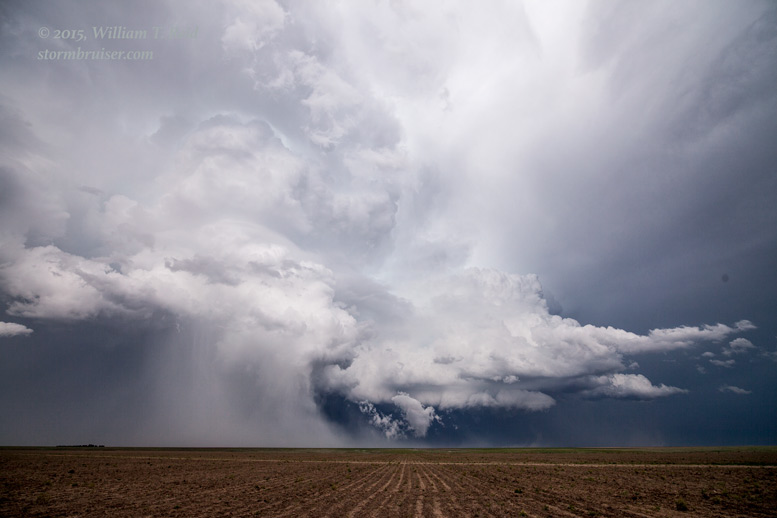
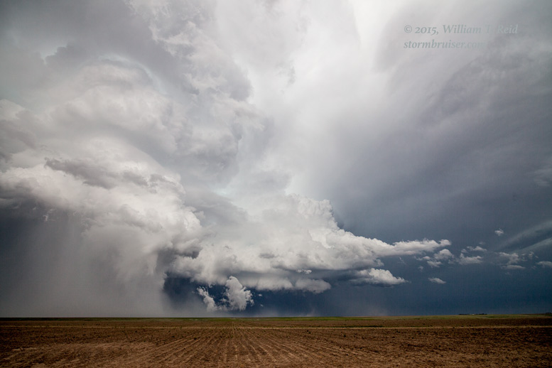
The 500 mb flow was from the NW to NNW at 45 knots or so. Rotating storms should move to the south today. The Saint Francis cell came into view as we motored past Colby, and it was a pretty, high-based LP supercell. As we neared Goodland, though, it was shriveling up. Fortunately, another storm had quickly gone up on the western side of the state line. We quickly came up to it at Kanorado. It was no more than five miles to our northwest and moving south, right over I-70. This supercell sported a lowering with rotation already. We were in Fat City! The lowering was somewhat high-based, and as it passed over our vans along the I-70 frontage road (old U.S. 24), a bit of a whirl whizzed by us from north to south. Stuff was happening beneath this one!
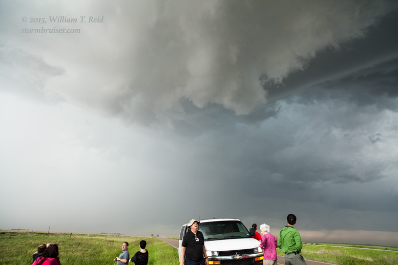

This was very cool, and the timing was rather remarkable. We had driven for more than six hours from Oklahoma City and managed to drive right up to a Colorado supercell — both storm and chase tour group arriving at the same point at the same time.
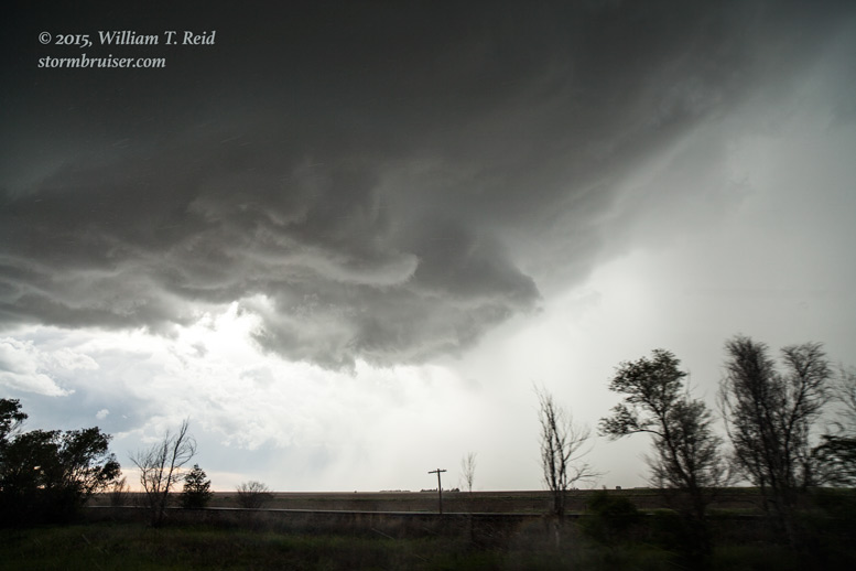
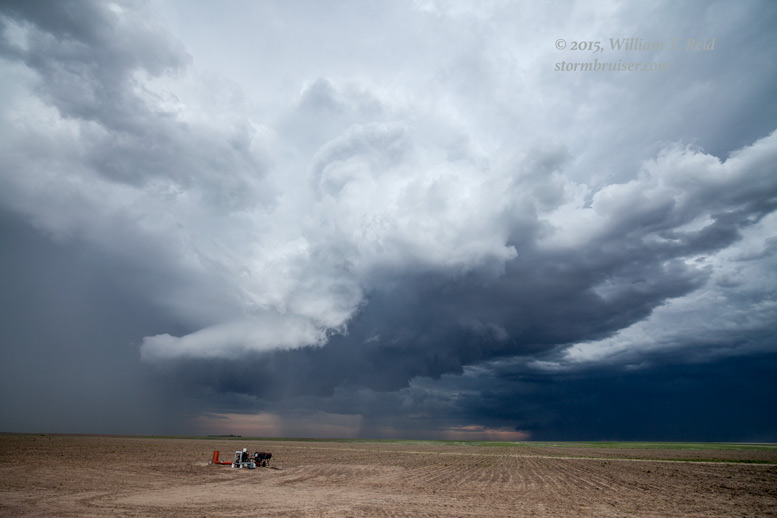
The paved road network out here is poor, and if we were to stay with this storm as it moved south of I-70, we would have to use an unpaved section road in extreme eastern Kit Carson County. County Road 59 southbound came in very handy, as it followed the southward-moving updraft perfectly. The storm core was just to the east of the road as was the updraft and rotating wall cloud.

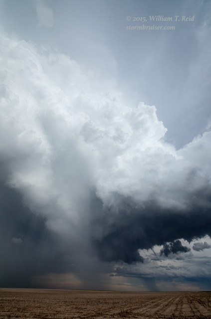
There was a brief window when the storm had a great look with perhaps an inclination to try to “tornado,” but it was content to just be a big hailer. A large swath of precipitation came around the back (north and northwest) side of the base, and started to moisten Road 59 in front of us to a somewhat uncomfortable degree. The storm was now diving south at about 35 to 40 mph and was difficult to stay with. After about 12 miles on Road 59, we went west a couple of miles, stopped, and watched the hailstorm move off to the south.

Not bad for a “marginal” chase day! Our home for the night was Holyoke.
Leave a Reply
You must be logged in to post a comment.