Yes, you guessed it. I NEED to be in Death Valley when the high temperature is near record levels. Maybe it is a sickness. I enjoy chasing severe weather, and I enjoy photographing interesting stuff like lightning and tornadoes and mountain wave clouds. But perhaps the ultimate achievement for a weather nerd would be to stand at or near a weather station at the same time that it is measuring a record temperature. An all-time authentic record temperature. For the Earth! One thing that might compare to this would be to stand in the middle of the eye of a Category 5 hurricane. But that is for crazy people.
First, of course, I need to set the table. The accepted all-time high temperature for the world, as of August, 2020, is the 134F report from Greenland Ranch in Death Valley on July 10, 1913. My research (starting with my Masters Thesis in 1987) demonstrates that the 134F report (and other maximum temperatures from July, 1913) is (are) likely not valid. The highest reliable maximum temperature at Death Valley weather stations up until the morning of August 16, 2020 was 129F. Regular records here go back to 1911. Thus, any day which flirts with 129F or thereabouts is important. A very impressive (i.e., large and strong) upper-level high/anticyclone took up residence near southwestern Utah and southern Nevada in mid-August, 2020. It was looking like the perfect weather pattern to promote near-all-time record maximum temperatures in the Mojave Desert and Death Valley regions. But, the calendar said mid-August, and not mid-July. Would that matter? (The record high temperature for August in Death Valley was 127F.) The answer was, “NO!” It did not matter, and on Sunday, August 16, 2020, the Death Valley station at Furnace Creek hit 130F! Check out my web site entry for more info on this record-setting day.
Well, darn, that was a BIT of a surprise. The forecast weather maps had been suggesting that the hottest days of this heat event would be Monday and/or maybe Tuesday. I had a work shift on this Sunday, and was thinking about heading to Death Valley on the following day to document the big heat. But it hit 130F a day before I could get there! Monday was still looking just as hot, and I needed to be in Death Valley if it hit 130F or higher. This is all-time record temperature territory for the entire planet, for as long as people have been measuring the air temperature. I didn’t necessarily need or want to be in Death Valley to experience brutal heat, but I needed to be there to document it for myself. And of course, it would be neat to say that I was there when it was REALLY 130F.
I have done several of these types of summer drives to document the temperature. One was in July, 2017, when the high was 123F. The primary reason for doing these, besides getting away from it all and enjoying the scenery, is to document and better understand the temperature patterns in the region on hot summer days. So, on Sunday evening, I threw everything that I would need into the Xterra for a long and hot drive the next day, and I set the alarm for 7 a.m.
I got on the road around 7:20 a.m. PDT. Skies were partly cloudy in the Thousand Oaks area, with some altocumulus around. The mid-level clouds were associated with a northward-moving plume of moisture on the western side of the upper high. The previous night featured a spectacular electrical display along and near the Central Coast of California. The thunderstorms initiated plenty of wildfires which were still in progress ten days later. There wasn’t much if any smoke in the Los Angeles area, but another fire near Cima (the Dome Fire?) was causing reduced visibilities in the Eastern Mojave Desert. Of course, if today was going to get close to 130F in Death Valley again, then clouds and smoke would have to steer clear of the region. I took this picture along Highway 14 above Palmdale around 8:30 a.m. The altocumulus clouds were still around, but towards Death Valley it was looking clearer. The visibility was around 50 miles or so. This value might seem pretty high, but there was a definite haze and maybe a little smoke around. That is not unusual for summer here.
For the drive I had my Kestrel thermometer taped to my outside rearview mirror. In the past, to determine the temperature, I would roll the window down and hold the Kestrel outside while driving down the highway. But this new method was much easier and safer, and I am glad I thought of it! The air would be passing through the instrument at high speed, and the measurements should be (and were) very accurate, and very representative. (I took the wind impeller out to keep that from falling apart.) The sixth image below shows the custom tape job. The Kestrel was about four feet above the ground. It is very sensitive to temperature, and it updates every second or so. The instrument’s temperature sensor is afforded some shade by the plastic, and direct sunshine likely hit the sensor during some of today’s measurements. But I have found that when wind is moving past the sensor, especially at highway speeds, any effects from direct sunshine are very minimal, or negligible.
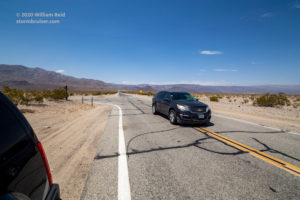
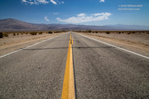
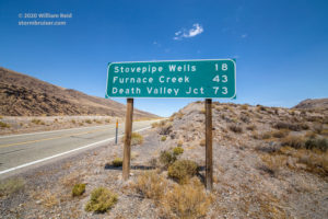
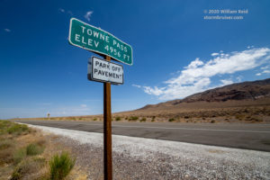
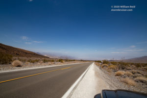
Skies cleared out nicely as I motored into Trona for a lunch stop. The temperature was 99F upon arrival in Trona at 10:40 a.m., and 105F when leaving about 45 minutes later. The first photo above is at the pass between Trona (in the Searles Valley) and the Panamint Valley. The next three were taken in the Panamint Valley, where mostly clear skies and good visibility prevailed. The next three images were at and near Towne Pass, between Panamint Valley and Death Valley along Highway 190. The last image was taken around the 2500′ elevation level, looking northeast into Death Valley. There is a light haze evident in the basin. Winds were mostly light for the morning and early afternoon hours, except that it was a bit breezy in the Panamint Valley. The temperature was about 111F at this stop on the west side of Death Valley, at about 12:45 p.m. PDT. Here are my morning observations, ending at about 12:30 p.m. at Towne Pass in the Panamint Range:
7:18 a.m. PDT/Westlake Village/69F
7:37/Simi Valley/74F
7:53/405 and 118 in Granada Hills/80F
8:00/5 and 14/83F
8:19/Escondido Summit Hwy 14, 3258’/84F
8:22/Hwy 14 Lake Palmdale/92F Calm
8:43/Hwy 14 and H in Lancaster/89F
8:51/Rosamond/87F
9:04/Mojave/93F
9:25/Hwy 14 California City exit/95F
9:39/Hwy 14 and Garlock Road/98F nearly calm
9:55/Garlock Rd. at Garlock/97F
10:06/Hwy 395 summit at Searles Station Cutoff/96F
10:12/Searles Station Cutoff and Trona Road/97F
10:19/Trona Road hilltop/98F
10:25/Hwy 178 and Trona Road/103F
10:30/Hwy 178 (Trona Road) at the Pinnacles Rd./102F
10:34/Westend/99F calm
10:40/Trona/99F
11:28/Inyo-San Bernardino County line on Trona-Wildrose Rd./105F Wind S 5 mph
11:40/Trona-Wildrose Rd at top of pass into Panamint Valley/106F Wind SW 10-15 mph
11:52/Trona-Wildrose Rd in Panamint Valley at Ballarat Road/113F Wind S 5 mph
12:02/Trona-Wildrose Rd in Panamint Valley at Indian Ranch Rd./115F
12:08/Panamint Valley Rd. at Minnietta Road/112F
12:15/Highway 190 and Panamint Valley Rd./114F
12:20/Highway 190 across dry lake bed in Panamint Valley/114F
12:22/Hwy 190 grade eastbound, 2000’/113F
12:25/Hwy 190 grade eastbound, 3000’/109F
12:28/Hwy 190 grade eastbound, 4000’/103F
12:34/Hwy 190 at Towne Pass, 4956’/96F wind E 10-15 mph, in shade from small patch of cumulus
Temperature fell a few degrees (103F to 99F) on the descent into the Searles Valley and Trona, which was a little surprising. But, it was only 10:30 a.m., so (presumably) some cool air from overnight was still waiting to be mixed out of the basin. The Panamint Valley, as expected, was a sneak preview of Death Valley. It bottoms out near 1100 feet above sea level near Ballarat, and is generally 5-6 degrees cooler than Death Valley on summer afternoons. Around noon this day (or around 11 a.m. standard time), the temperature readings in Panamint Valley were mostly 112F to 115F. Unlike the Searles Valley an hour earlier, it was somewhat breezy here.
It was almost midday in summer in the Panamint Valley, and it was a scorcher! But, I was doing the math in my head, and it didn’t quite seem like it was a day that was going to smash all-time temperature records. A 114F at Panamint Valley suggests that Death Valley would be about 120F. It was noon, and typically temperature rises another 7-8 degrees after noon (i.e., after 11 a.m. PST).
On the grade up to Towne Pass, from about 1600 feet to 4950 feet elevation, temperature fell from 114F to 96F in 19 minutes. The cooler air felt nice, but it was short-lived. Here are the observations along Highway 190 to Stovepipe Wells in Death Valley.
12:34 p.m. PDT/Hwy 190 at Towne Pass, 4956’/96F
12:38/Hwy 190, 4000’/101F
12:42/Hwy 190, 3000’/106F
12:45/Hwy 190, Emigrant Ranger Station/111F
12:46/Hwy 190, 2000’/112F
12:49/Hwy 190, 1000’/116F
12:52/Hwy 190, about 300’/120F
12:55/Hwy 190, Stovepipe Wells (+5′ elevation)/121F wind near calm
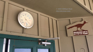
I stopped in Stovepipe Wells and photographed a couple of outside thermometers. Unsurprisingly, even though they were in the shade, these registered several degrees warmer than the readings that I was getting off of the Kestrel as I rolled into the village. By the way, the NOAA Stovepipe Wells station, about 80 feet higher than the village, showed a 118F temperature about this time.
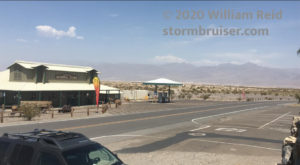
The first picture above shows a round “dial” thermometer. (Also called a “bimetal” thermometer.) It was right up against the southeast-facing wall above the front entrance of the Stovepipe Wells General Store. Tucked under a very large and shady eave, this thermometer probably receives little or no direct sunlight in summer. But, this side of the building would be in a lot of direct sunlight during the morning. At close to noon-time standard time (1 p.m. PDT), this dial thermometer showed 125F, about four degrees higher than my Kestrel readings. The General Store is shown below, looking to the north here.
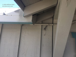
The digital thermometer shown above (with 125.2F) is in a small office building directly across the street from the store. It is connected by a wire to a sensor situated against the outside wall and under the eave of the building. Though this side of the building is facing to the northwest and has been on the opposite side of direct sunlight thus far today, the temperature displayed is also four degrees above the ambient air temperature that I was observing off of the Kestrel (and 6-7 degrees warmer than the nearby NOAA station). If you lived in Stovepipe Wells and relied on these two thermometers, you would probably think: “Hey, the thermometers are both in the shade and they both show about 125F. It must be 125F right now!” But it was actually a lot closer to 120F. These thermometers may be accurate, but they are not exposed properly. It seems likely that some (early) temperatures read off of “ordinary household” thermometers at Greenland Ranch, including temperatures of 130F or more on the hottest summer afternoons according to the caretakers, were much higher compared to legitimate ambient air temperature because of very poor exposure.
The remainder of the drive to Furnace Creek would be mostly below sea level. Here are my readings:
1:11 p.m. PDT/Hwy 190, east edge of Stovepipe Wells/121F
1:13/Hwy 190 at Mesquite Dunes/121F
1:16/Hwy 190 at Devils Cornfield/124F
1:18/Hwy 190 at sea level sign/121F
1:19/Hwy 190 at Scottys Castle Road/123F
1:22/Hwy 190 at sea level sign/122F
1:23/Hwy 190 at Salt Creek Road/122F
1:25/Hwy 190 at Beatty Junction/123F
1:27/Hwy 190 south of Beatty Jct/wide swing of temperature from 122F to 128F
1:39/Hwy 190 at Cow Creek/124F
1:40/Hwy 190 at Harmony Borax Works/124F
1:42/Hwy 190 at the NPS Visitors Center in Furnace Creek/123F
At about 1:27 p.m. PDT (while driving) I watched the Kestrel hover around 122F for a bit, but then it quickly jumped to 127.7F. Temperature then decreased fairly quickly back to about 124F. This “bounce” to almost 128F lasted for just a few seconds at 55 mph. It was more or less the norm to see the Kestrel bounce up and down in temperature as I drove through little heat bubbles, but this one at 13:27 was very pronounced. Quick temperature changes of roughly 3-4 degrees were numerous. And, I must admit, that brief increase to 128F was quite the rush! The highest temperature that I had ever measured in Death Valley was 126F, up until now. That 126F reading was with my trusty sling psychrometer, some 30-35 years ago.
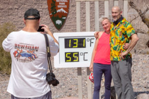
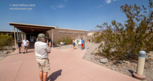
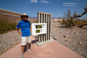
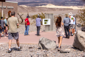
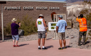
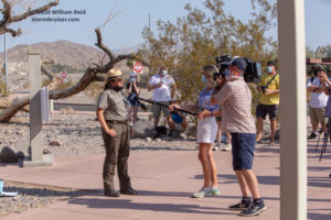
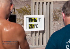
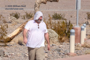
I found a shaded parking spot at the (closed for COVID) visitors center, and got some pictures of Death Valley visitors huddled around the very unofficial digital thermometer display. Okay, so “huddling” is not the best word to use here, but I like it. My Kestrel readings were generally 4-5 degrees LOWER than the display temperatures. I then walked around the official weather station area from about 2:20 to 2:30 p.m. with the Kestrel. The wind was light and from the south. My readings taken close to the fenced weather station were mostly 124F to 125F. It wasn’t unusual to see the Kestrel jump up briefly to 126F or so and then come back down to 124F. These changes in temperature were real — I could feel the differences and the changes on my skin! Just to the east of the weather station are a relatively-small covered parking area, the paved access road to the parking spots, and a little array of solar panels which are perhaps four-to-six feet off of the ground. The wind was near calm and the Kestrel came up to about 126F-127F in this area, no more than 35 meters from the weather station. On the short walk back west to the weather station, past the solar panels and past the parking area, the Kestrel continued to show increasing temperature, and was holding strong with values of 128-129F! About 10 meters from the weather station, my Kestrel showed 130.3F! A few more steps towards the station, and it dropped down a degree or two. The little “blob” of air with a temperature of 130.3F sure felt like it — i.e., it felt quite a bit hotter than the 125F-126F that had been the “average” conditions for the past 10 minutes with the Kestrel. I do believe that 130.3F reading. The wind at the station was SE at perhaps 3-4 mph as I walked up to it. I contend that this “hot pocket” or “superheated blob” was due in large part to the very light winds in the immediate area. I am not sure if the asphalt pavement and the solar panels were an important factor in causing the blob. But, I do believe that the general buildup of “stuff” and vegetation in this area near the weather station contributes to the generation of ENHANCED transient heat bubbles. Out in the wide open spaces of Death Valley, such obstacles to the natural flow of air are absent, and any such heat bubbles are less hot comparably.
I made a similar walk around the weather station from 3:00 to 3:05 p.m. My Kestrel readings were mostly 124F to 125F. I did the walk to the solar panels area and back to the station, and this time the temperature stayed close to 126F. At the same time, the public digital thermometer display in front of the visitors center was reading 130F to 131F.
One more trek around the weather station was performed from 4:05 to 4:10 p.m., and my Kestrel readings were mostly 124.0F to 125.5F and big temperature jumps were not observed. Official readings from the Death Valley weather station ranged from 124F to 126F for the most part from 2 to 4 p.m., which nicely matched my Kestrel readings. The highest reading from the station was 126.6F at 3 p.m. PDT. If that 130.3F “heat bubble” just to the east of the station managed to affect the Campbell Scientific thermometer sensor, then it must not have persisted for long enough to permit an official reading as high. Official temperatures are likely based on averages perhaps up to five minutes in duration, and not on instantaneous temperatures such as that off of my Kestrel instrument.
Let’s look at my pictures from today. This first batch is also included in the companion article which discusses the Death Valley Weather station exposure:
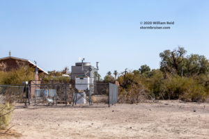
Image 1) looking NW from the walkway near the west side of a Visitors Center building towards the weather station. The white shelter can be seen between the trees. On the left are the two brick-housed “units” of some sort — an a/c unit and something else. These two units are directly south of the instrumentation.
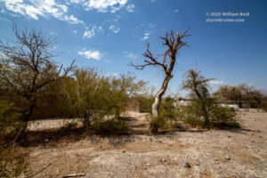
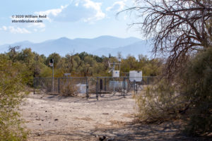
Image 2) looking NE towards the Death Valley weather station. Little or no rain since winter has left the vegetation looking very bleak near the fenced station area. Not too far NE of the station is a rather dense, ground-hugging tree (mesquite?). To the east is a white propane tank, perhaps, and the parking area for the NPS employees of the Visitors Center. The dead-looking vegetation in the foreground does little to keep the ground around the station from getting very hot during the high-sun hours of summer.
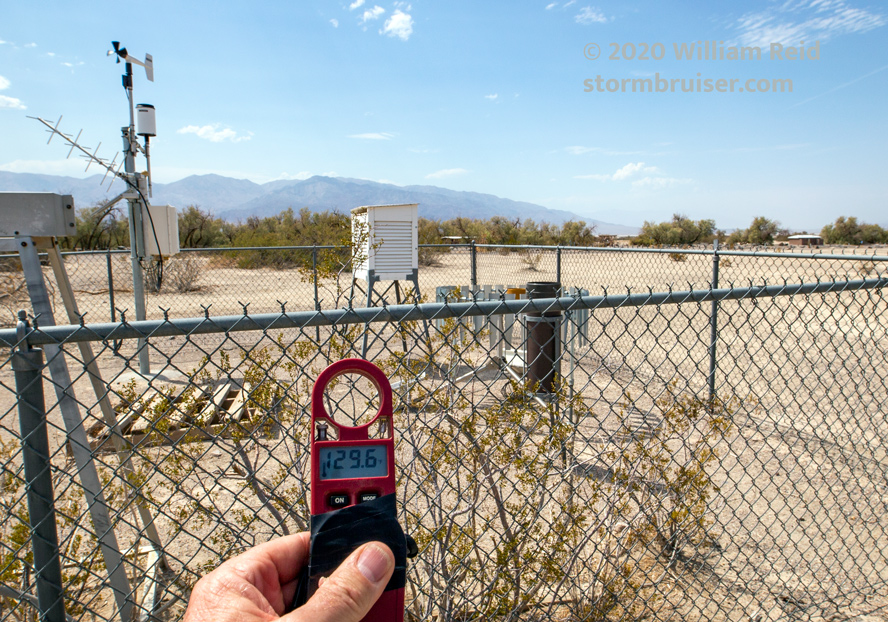
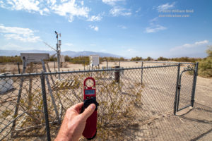
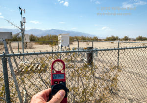
Image 3) looking to the west from the east side of the weather station. The Kestrel reads 129.6F, moments after showing 130.3F a few steps east of this spot. To the west and northwest of the station is some scattered low vegetation and a campground. The campground is not used much during the summer. Since it is not too close to the station and since it doesn’t slow the wind down much, if any, in summer, I doubt that the campground affects temperature measurement at the station in summer. But, that bush growing right along the east-side fence might not be ideal.
Image 4) a similar shot to Image 3 but with a closer view of the Kestrel reading.
Image 5) the view through a longer lens towards the NW. Those first four photos were with a wide-angle lens. This shot compresses the depth of field quite a bit, and some campground facilities and a road can be seen to the northwest.
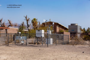
Image 6) a view to the SSW of the Death Valley weather station. Very prominent is the 2-story auditorium in the Visitors Center area. To the right of that (south of the station) are the Evapco unit and the other walled-in infrastructure of some sort. Summer afternoon winds are usually from the south. All of these obstacles to the south of the station slow the prevailing wind down and allow heat to build up in and around the station, and thus hotter maximum temperatures are realized comparably.
Image 7) the view to the south, from just north of the station. Yes, it does appear that ventilation through this area would be reduced due to the nearby obstacles to the flow.
Image 8) the view to the SW, from just NE of the station. Again, this is a bit of a compressed look given the 70mm focal length employed, but plenty of tall vegetation looms not too far to the southwest of the station, also. This vegetation to the south of the station is near the northern edge of the golf course at Furnace Creek. Decades of heavy irrigation of the golf course have no doubt permitted (what would typically be) low and meager vegetation on its northern fringe to flourish.
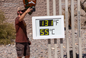
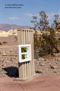
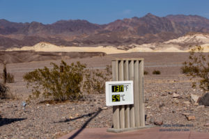
The images below were taken between about 2 and 4 p.m. at and around the NPS Visitors Center public digital thermometer display. It is a fun “exhibit,” but it reads about 4-5 degrees (F) too high in the summer afternoon sun. The NPS personnel are well aware of the difference in temperature measurement between this display and the official weather station, but they aren’t too concerned.
It is interesting that the NPS updated the display to also include a “Celsius” value. Back in 2017, it was Fahrenheit only. I suspect that the NPS is trying to placate the large contingent of summer visitors from Europe. It seems that some Europeans are keen to experience the great summer heat of the Mojave Desert and Death Valley first hand. The summer of 2020 was strangely short on Europeans in Death Valley, however, due to the ongoing COVID pandemic and travel restrictions and risks. The Celsius display was occasionally on the fritz during my visit, showing 59C when it should have been at 55C. And, the last digit of the Fahrenheit temperature had problems.
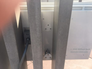
I bet that you are just itching to see the back of this digital temperature display! Look below!
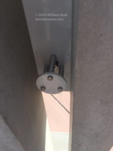
There are vertical metal supports behind the white, metallic temperature display. A metal thingamajig sticks out between two of the supports. The air temperature sensor might be associated with this. It looks like the power connection is to the left. It is interesting that there is an alternate spot for the sensor (I am presuming here) a little higher. I wonder if that other spot was used at one time, and if the sensor was subsequently lowered. The sensor is pretty close to the ground as it is (about waist level), which might explain the extra-hot readings. Another possibility for the too-high readings is that the metal supports heat up a lot in the sunlight, and the warmth migrates by conduction to the shaded parts near the sensor.
Lucky for you, I have more thermometer pictures to share! The two images below show a dial thermometer on the east side of the Furnace Creek gas station. It is in the shade, as these were taken around 3:30 p.m. Y’all know where the sun is in the sky at 3:30 p.m., right?
And, once again, the thermometer, showing about 130F, was reading at least a few degrees higher than the true ambient air temperature. If you were in charge of hanging this outside thermometer on the wall, would you put it inches away from the air-conditioner?
The lesson of the day on this trip is that all of the “ordinary household” thermometers encountered in Death Valley showed temperatures that were about five degrees (F) higher than the actual ambient air temperature. Even in the shade, the thermometers read too high because the adjacent building and ground area are radiating heat. The thermometers show the correct temperature. But it is the correct temperature of air just a centimeter or two from the side of a structure. That is called bad exposure.
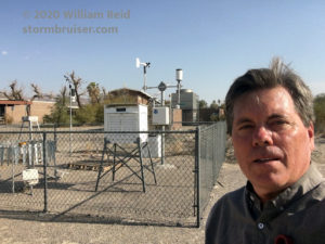
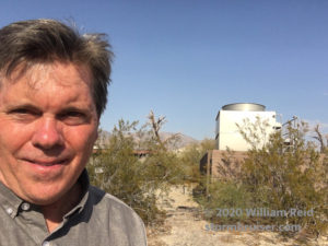
And since you made it down this far, here are two selfies of me on this day. I am at the Death Valley weather station about the time that it was 127F! My iPhone stopped working a couple of times when trying to take photos around the weather station. It said that I needed to cool the phone down before it would be of any use again. Good luck.
What was it like to be out and about in the hot sunshine in temperatures like that? It is not really easy to describe. It is sort of like the air has wrapped around you as a blanket does, with no way to unwrap yourself to “undo” the hot sensation. While outside in these temperatures, you feel like you are slowly being beaten down by the air. I generally do quite well in hot weather. I drink plenty of water or ice tea to keep well-hydrated, and I find that it is very important to eat regularly, too. It is easy to find oneself getting a little woozy and out of sorts if in the sun for too long in these conditions. It is imperative to take occasional inside air-conditioner breaks, or at least extended shade breaks with a spray bottle! The human body did not evolve to operate normally in the bright sunshine in air temperatures of 125 to 130F, and above ground surfaces with temperatures approaching 200F.
One other rather odd, but I suppose not surprising, thing about everyday activities in the outside heat of Death Valley in summer, is that EVERYTHING is HOT! Well, duh! But it really is amazing to touch objects that have been in the shade and to feel how hot they are. They feel like they have been in the sun. Metal objects practically burn the hand, even when in the shade, when the air temperature is 126F.













Leave a Reply
You must be logged in to post a comment.