On August 17, 2020, I took a drive to Death Valley and took the photos below. This was a day after the station had a high temperature of 130F, which is the highest here since 1913, and probably its most reliable high temperature on record. In my estimation, an increase in vegetation and man-made structures mostly south of the station have significantly decreased the wind flow through the station area on most summer afternoons. (See Roof and Callagan article in BAMS, 2003, for additional details on wind movement through the station.). The decrease in wind movement and mixing has led to higher maximum temperature measurement comparably. For example, from 1911 to 1987, three summers at Greenland Ranch/Death Valley had authentic maximums as high as 127F. From 1988 to 2020, 18 summers reached 127F or more! Perhaps global warming is partly the reason for the higher maximums in the past three decades. But when the exposure of the instrumentation has changed at long-term stations, it is more difficult to determine just how natural any temperature changes are.
This entry reiterates much of what I have already said elsewhere in various Death Valley entries in Stormbruiser, but this one here again tries to summarize my thinking as of 2020!
Eight images are below (we will call them Images 1 through 8), and the descriptions are below that.
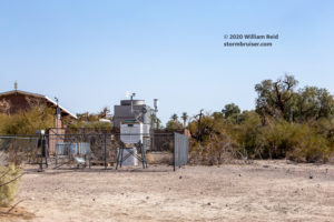
Image 1) looking NW from the walkway near the west side of a Visitors Center building towards the weather station. The white shelter can be seen between the trees. On the left are the two brick-housed “units” of some sort — an a/c unit and something else. These two units are directly south of the instrumentation.
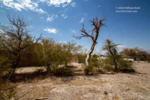
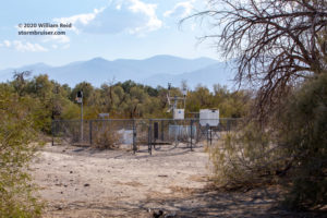
Image 2) looking NE towards the Death Valley weather station. Little or no rain since winter has left the vegetation looking very bleak near the fenced station area. Not too far NE of the station is a rather dense, ground-hugging tree (mesquite?). To the east is a white propane tank, perhaps, and the parking area for the NPS employees of the Visitors Center. The dead-looking vegetation in the foreground does little to keep the ground around the station from getting very hot during the high-sun hours of summer.
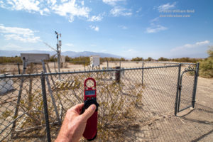
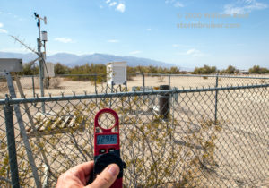
Image 3) looking to the west from the east side of the weather station. The Kestrel reads 129.6F, moments after showing 130.3F a few steps east of this spot. To the west and northwest of the station is some scattered low vegetation and a campground. The campground is not used much during the summer. Since it is not too close to the station and since it doesn’t slow the wind down much, if any, in summer, I doubt that the campground affects temperature measurement at the station in summer. But, that bush growing right along the east-side fence might not be ideal.
Image 4) a similar shot to Image 3 but with a closer view of the Kestrel reading.
Image 5) the view through a longer lens towards the NW. Those first four photos were with a wide-angle lens. This shot compresses the depth of field quite a bit, and some campground facilities and a road can be seen to the northwest.
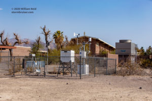
Image 6) a view to the SSW of the Death Valley weather station. Very prominent is the 2-story auditorium in the Visitors Center area. To the right of that (south of the station) are the Evapco unit and the other walled-in utility of some sort. Summer afternoon winds are usually from the south. All of these obstacles to the south of the station slow the prevailing wind down and allow heat to build up in and around the station, and thus hotter maximum temperatures.
Image 7) the view to the south, from just north of the station. Yes, it does appear that ventilation through this area would be reduced due to the nearby obstacles to the flow.
Image 8) the view to the SW, from just NE of the station. Again, this is a bit of a compressed look given the 70mm focal length employed, but plenty of tall vegetation looms not too far to the southwest of the station, also. This vegetation to the south of the station is near the northern edge of the golf course at Furnace Creek. Decades of heavy irrigation of the golf course have no doubt permitted (what would typically be) low and meager vegetation on its northern fringe to flourish.
A couple of the earliest images of the station are included in this Death Valley weather history summary (pages 9-10) by Chris Stachelski about ten years ago. Yes, there was some rather dense vegetation SSE of the instrumentation back in the early days, also.
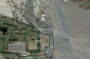
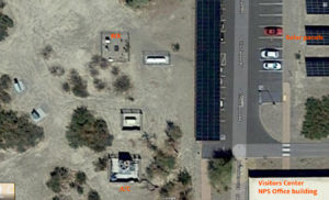
I chatted quite a bit about the effects of the surrounding impediments to the wind in my July 2017 web entry. Included there was a Google satellite image of the area around the weather station. Let’s go ahead and include similar images available today. These are from 2020, according to Google.
The image on the left is a wide view. “WX” is the location of the current Death Valley station, northwest of the Visitors Center, and in that same place since 1961. “GR” is the location of the Greenland Ranch instrumentation during the 1940s and 1950s. This shot below from 2020 shows the very open space due south of the site of the last Greenland Ranch instrument location.
The zoomed-in look of the current Death Valley station area shows the relatively new heating/cooling-related infrastructure to the south of the station. For scale, the fenced sides of the weather station are about 20 feet in length. Short trees and tall shrubs are not too far to the W, SW, S and SE. The Visitors Center buildings are to the SE. The parking lot and its vehicles and shade-providing canopy are nearby to the E, with the solar panels a little farther to the E. And, it appears that additional solar panels are on top of the parking lot canopy.
The wider-angle look shows additional vegetation, especially S and SW of the station, along the edge of the golf course.
If you want to maximize the high-end-temperature potential of your weather station, then you might do well to replicate the current environment around the Death Valley weather station. Let’s back up some for a little story. Back in the early 1980s, I was doing my temperature research of the Mojave Desert for my Masters Thesis. I spent some time out at Zzyzx (also known as Soda Springs and the Desert Studies Center), south of Baker. I was comparing summer high temperatures in the region with those at Zzyzx and Baker. I was rather perplexed when I found that the summer high temperatures from the thermometer shelter at Zzyzx were consistently 3 to 5 degrees LOWER than those at Baker. The Zzyzx shelter was well-exposed and above bare ground. The maximums here were fairly conservative, especially since the shelter was positioned just south of a big and shady palm tree. I figured that the palm tree shade likely resulted in lower maximums by maybe a degree or two at Zzyzx. In contrast was the cooperative station in Baker. The elevation here was pretty much the same as at Zzyzx. Baker was on the north end of Soda Dry Lake, and Zzyzx was on the west side. But, the Baker station, moved to the Caltrans maintenance yard in 1979 or 1980, was NOT well-exposed. In fact, the Baker shelter was above bare ground and in this somewhat large “yard” with tall trees around the perimeter. These trees, alongside some heavy equipment and vehicles in the yard, significantly diminished the wind and the mixing at shelter level in the yard. Plenty of direct sunshine on the bare ground in the yard promoted very hot surface temperatures on summer afternoons, and the poor ventilation resulted in inflated high temperatures comparably. The Baker weather station was moved again, thankfully, around 1984, to a better-exposed location in town. But if the Baker maximums in summer are compared through the years, you will see that the average maximums for the summers of 1980 to 1983 are much closer to those at Death Valley versus all other years. A similar story can likely be told for the weather station at Lake Havasu City when it soared to 129F back in the 1990s. Its weather station, guaranteed, was above bare ground and in a spot where the exposure and ventilation were less than adequate. This weather station at Lake Havasu City was moved to a better-exposed place shortly after the 129F maximum. Back in the 1980s, when I was closely monitoring the Zzyzx maximums and the Baker maximums, I thought that that shady palm tree was responsible for most of the difference in maximum temperature between the two stations. But it was not — it was much more the different station exposures which caused the 3-5 degree (F) differences. The bare ground desert surface gets amazingly hot in summer. Areas where ventilation is hindered or diminished can really heat up in the afternoon in summer. If one is interested in acquiring fair and legitimate comparisons of maximum temperatures between regional desert stations, then great care must be given to station siting and exposure. If one is interested in setting up a weather station in the desert that is going to go crazy on hot maximum temperatures, then site it above bare ground and in a spot where wind is greatly diminished due to nearby obstructions, such as buildings and vegetation.
How about another flashback! Back in the 1980s, when I visited the Death Valley station on summer afternoons, my psychrometer walks suggested that the station area was somewhat cooler than other parts of the Furnace Creek area. I surmised that the well-irrigated lawn of the Visitors Center to the south was in part responsible for this. The Death Valley weather station area appeared to be quite well-exposed. With a south breeze on most summer afternoons, air through the station area might be cooled slightly due to evaporative effects. The lawn was taken out and replaced with a more natural desert surface around 2012. Fast-forward to 2020: the result of decades of irrigation is some super-sized desert plant life near the golf course and the Visitors Center former lawn environs. The landscape just a stone’s throw to the SE, S and SW of the weather station currently is a veritable wall of vegetation and man-made buildings. Ventilation through the weather station area is much poorer compared to the first three decades here (1961 to 1990). So, whereas there was a decent breeze from the south off of the golf course and Visitors Center lawn through the weather station previously, now the southerly afternoon breeze is interrupted and weakened. Mixing is reduced on summer afternoons above the bare ground around the station area. The black tops of the solar panels along the asphalt nearby to the east are good additions to the area, too, if one is inclined to promote higher maximums at the station.
The Death Valley weather station is arguably the most important weather station in the world, especially for climate studies. Unfortunately, the government institutions (NPS and NWS) have been too lax when it comes to ensuring minimal changes in the near-station environment. I would suggest that one of two changes be made, especially before any more record-breaking high temperatures can occur:
- Move the Death Valley station to an area almost entirely free of obstructions to the south, such as a spot just to the east of Highway 190, east of the Visitors Center (similar to the final spot for Greenland Ranch)
- Leave the current station where it is, but take out those relatively new (brick-walled) facilities just south of the station, and do some big-time cutting back of any vegetation taller than about six feet between the station and the Visitors Center parking lot area.
The bottom line is that the exposure of the current Death Valley station continues to slowly decline. If and when record maximum temperatures occur here in the future, climatologists should not have the opportunity to point out that the record is flawed, or is perhaps less-than-100 percent legitimate, because the station exposure is much poorer compared to earlier decades.
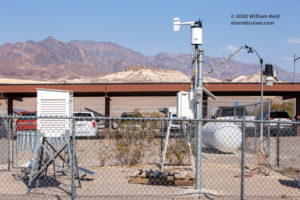
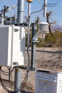
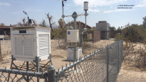
Below are some additional images of the weather station area, especially of the Campbell Scientific instrumentation (which is currently employed for the official temperature readings).
In each of the five images above, the radiation shield for the electronic temperature sensor is visible. It is white and has the stack of six plates. It is designed to permit normal air flow through the shield and across the sensor, and it is designed to mitigate any effects from direct solar radiation, such as heating of the shield which could affect air temperature measurement. There are different types of radiation shields, and some are better than others. Problems (i.e., periods where air temperature measurement drifts upwards to levels above actual ambient air temperature) sometimes develop when there is little or no wind movement during sunny conditions.
The radiation shield and its temperature sensor appear to be at about shelter-top level, or close to about 6 feet (two meters) above the ground. That is a good height for the official Death Valley temperature sensor, especially given the typical very bare surface in and around the weather station area. Climatologists don’t want to have to contemplate that the thermometer or sensor was or is too close to the hot ground. GOOD!
The radiation shield and the associated instrumentation are not too close to the other instruments in the weather station corral. GOOD!
The radiation shield is anchored quite closely to a silver/metal support and to a white box (plastic?) which presumably houses the “electronic brains” of the station. MAYBE NOT GOOD!
The radiation shield is indeed rather close to these weather station supports and devices. After sitting out in the direct Death Valley sun for hours on a summer afternoon, would not these items get much hotter than the ambient air temperature? Could not a little drift of wind from the east cause an artificial increase in temperature measurement? These possibilities do not seem all that remote to me. I figure that it would be better to have that sensor at least 12-18 inches from anything else, especially from anything metal which is going to get really hot in the desert sun.
Few weather stations are completely perfect for the entirety of their period of record. The current Death Valley station was established at a suitable spot, but the Furnace Creek area has had some changes through the decades, and these changes have affected the station. (For more background on Death Valley weather station history, including the timeframe when the “MMTS” system was in place, see this article by Anthony Watts!). The current Death Valley weather station is now situated in spot that is not particularly suitable, because its exposure has been gradually compromised with time. I hope that a change is made to improve the station exposure. If a new high-temperature record is set, we climatologists would prefer NOT to have to contemplate the veracity of the record due to station exposure issues.
———-
Summer 2021 EDIT!! I am not really happy with part of the final paragraph above. Yes, the Death Valley station “was established at a suitable spot” back in 1961. I state above that the station is now in a spot “that is not particularly suitable.” A better phrasing would be “the current Death Valley station is now situated in a spot which has become less-and-less suitable for allowing fair comparisons with high temperatures of earlier decades.” The current site has a warm high-temperature bias. The exposure of the site is not poor, but it is not nearly as good now as compared to Greenland Ranch (1911-1960) and the first three decades of “Death Valley” (1961-1990).







Leave a Reply
You must be logged in to post a comment.