
At Los Angeles Airport (LAX), weather observers are tasked with determining the “prevailing visibility” for each observation. As a weather observer, I figured that it would be helpful to determine the distance of easily-identifiable objects that can be seen from the control tower. We observe the sky conditions and determine the prevailing and sector visibilities from outside platforms off of the 16th floor of the control tower (about four floors below the ATC tower cab). Yes, a map showing a number of visibility markers from LAX is already available, but this entry should serve as a nice supplement.
I took a series of photographs from the control tower platforms, starting to the north and working my way around the horizon to the E and S and W and N again. These 24 images were with a full-frame DSLR camera and a zoom lens set at 100 mm focal length. There is a little overlap from image to image.
The images were taken on January 12, 2023, around 2 p.m. PST. The sun was about 30 degrees above the horizon in the southwest sky. Skies were clear and visibility at the time was excellent, with mountains as far as 100 miles away visible. This was a typical clear winter afternoon in the Los Angeles area with weak-to-moderate offshore flow and low humidities. I have seen afternoons with somewhat better visibilities, especially for areas towards the ocean (S to W), but this day was still fairly high-end with regard to visibility.
Below are the 24 images around the horizon from the LAX control tower. Distant mountain elevations and distances are shown. Closer objects are notated with a letter and the distance in miles. A “key” to each image is provided below this set of images. This key provides information related to each lettered object. Click on an image to enlarge it!
NORTH SECTORS
NORTHEAST SECTORS
EAST SECTORS
SOUTHEAST SECTORS
SOUTH SECTORS
SOUTHWEST SECTORS
WEST SECTORS

NORTHWEST SECTORS
Above is a link to the list of visibility markers in pdf format, which opens in a new tab and may be a little more manageable for you than the long list below!
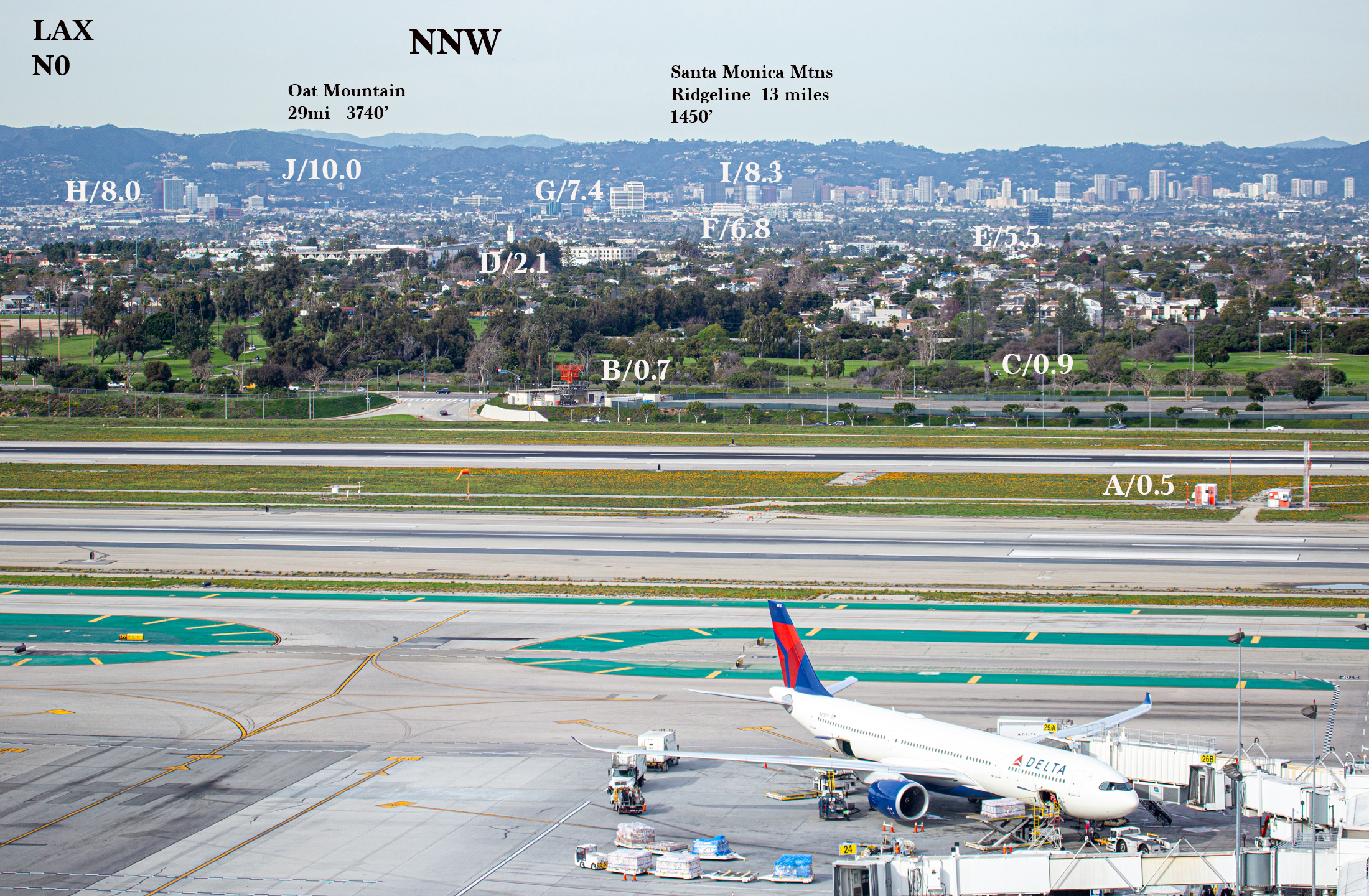
LAX N0 NNW
A/0.5 miles Weather instruments between runways (orange and white)
B/0.7 miles (3725 feet) Orange/red aviation radar and traffic signals along Lincoln Blvd.
C/0.9 miles Golf course north side of Westchester Parkway
D/2.1 miles Loyola church tower/White 4-story housing just to the right is 2.0 miles
E/5.5 miles Black 10-story True Car building along 405 near National
F/6.8 miles B&W Pacific Western Bank (10-story) at Sepulveda and Olympic
G/7.4 miles B&W 20-story building at Sepulveda and Santa Monica
H/8.0 miles 20-story-plus skyscrapers near Wilshire and San Vicente (West L.A.)
I/8.3 miles Skyscrapers lined up along Wilshire corridor (West L.A.)
J/10.0 miles Light-colored Getty Museum on hillside
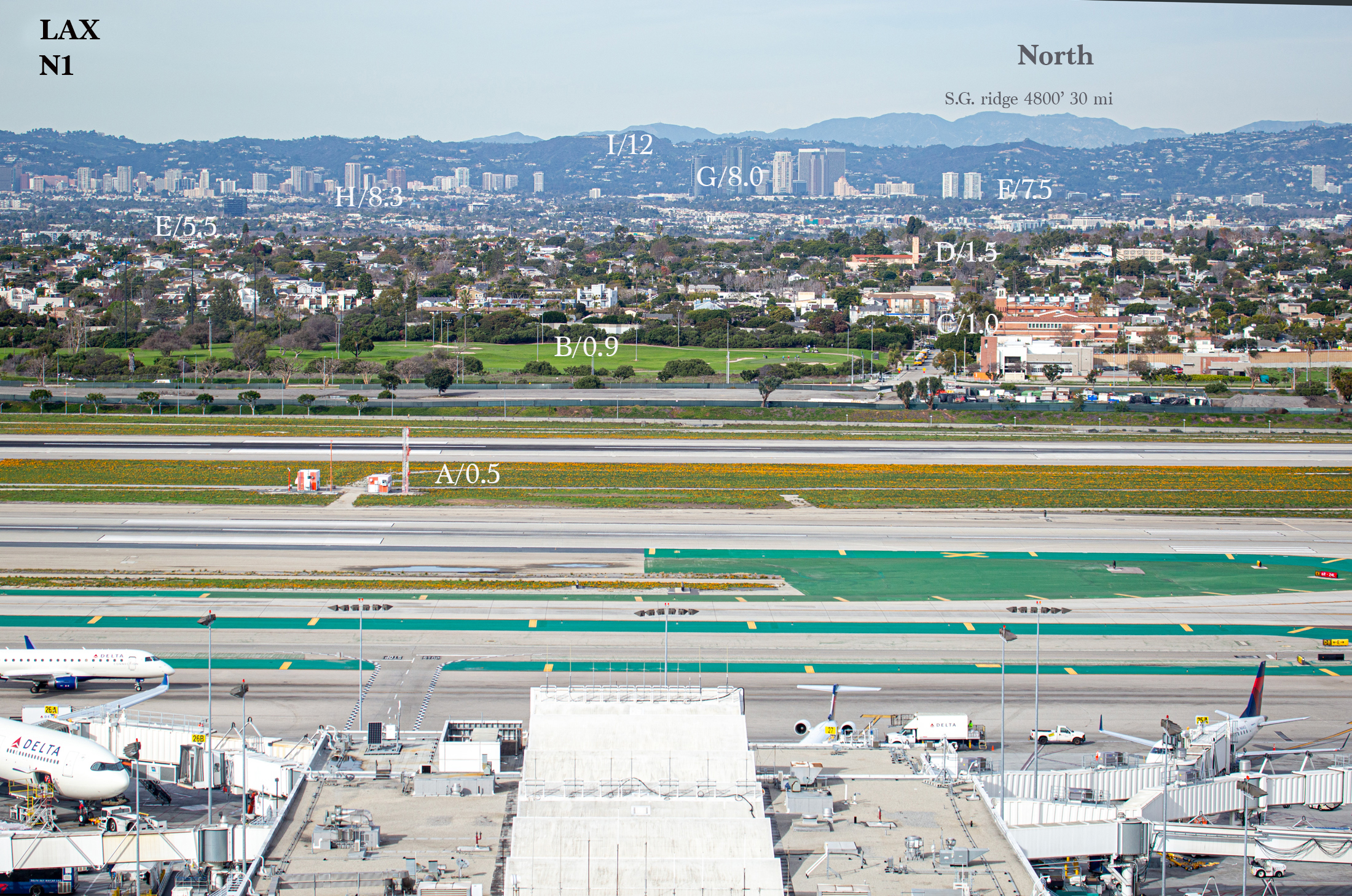
LAX N1 NNW to N
A/0.5 miles Orange and white instrumentation between runways
B/0.9 miles Golf course fairway
C/1.0 miles Visitation Catholic Church bell tower (close to due north)
D/1.5 miles Westchester Methodist Church tower
E/5.5 miles True Car 10-story dark building along 405 near National
F/7.5 miles Century Towers, twin white skyscrapers
G/8.0 miles Century City skyscrapers
H/8.3 miles Skyscrapers along Wilshire Blvd. corridor in Westwood area
I/12 miles Ridgeline of Santa Monica Mtns behind Century City (elev. about 1400’)
Note: far end of Terminal 2 building is a little less than 1/4 mile distant
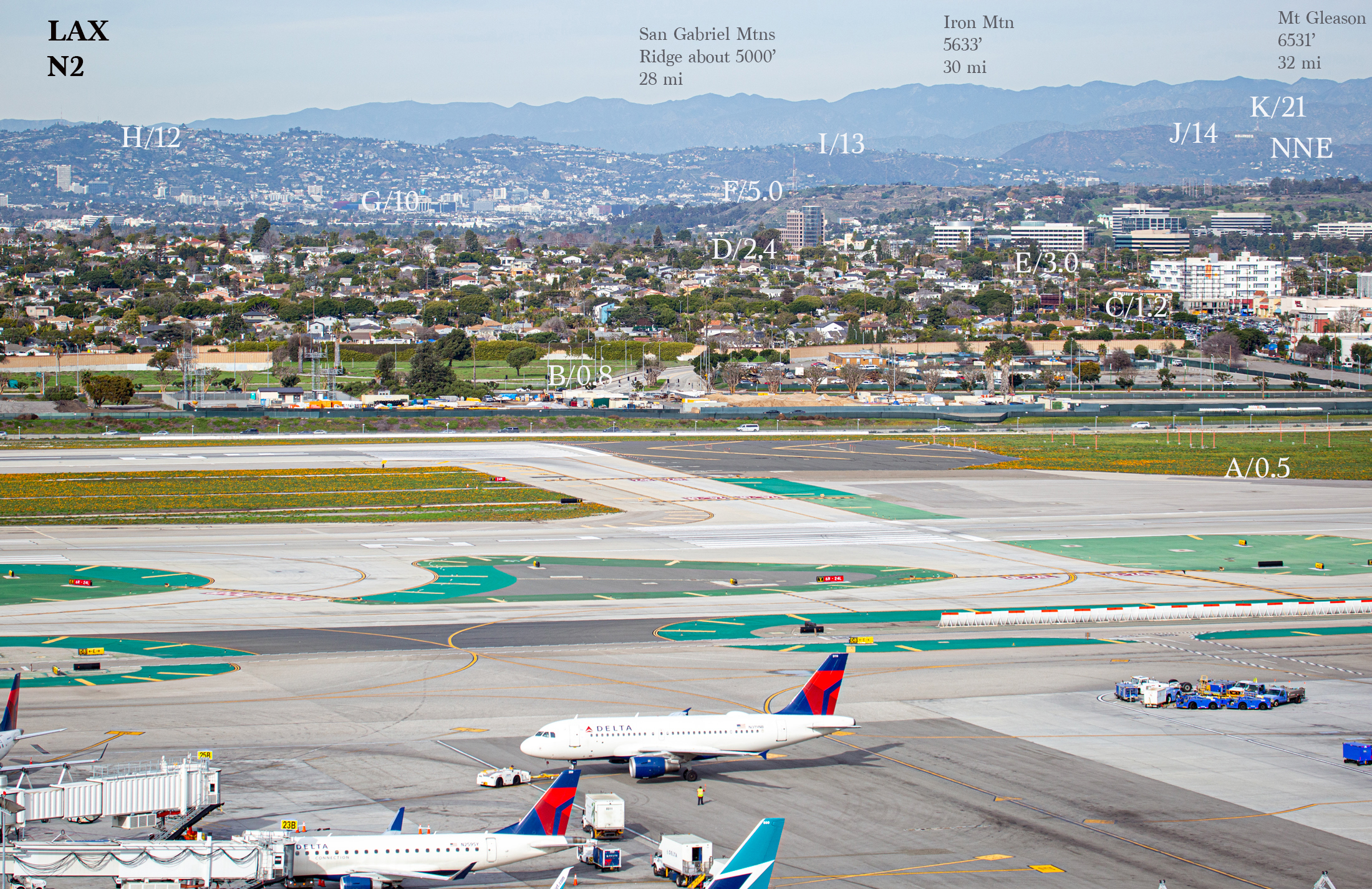
LAX N2 N to NNE
A/0.5 miles East end of northern-most runway
B/0.8 miles Traffic signals at La Tijera and Westchester Pkwy
C/1.2 miles White 6-story apartment building at Sepulveda and Manchester
D/2.4 miles Brown 16-story building with rounded glass side at H. Hughes Ctr
E/3.0 miles Cluster of light-colored 5 to 10-story structures Fox Hills/Culver City
F/5.0 miles Radio tower/Baldwin Hills just behind H. Hughes Ctr (elev. 400’)
G/10 miles High-rises along Sunset Strip to NNE, including Cedars Sanai Hosp.
H/12 miles Crest of Santa Monica Mountains just east of due north (elev. 1562’)
I/13 miles Santa Monica Mountain peak behind Baldwin Hills (elev. 1490’)
J/14 miles Hollywood Sign, Mount Lee and Cahuenga Pk (at 1826’ to left of sign)
K/21 miles Vedugo Mtns and Verdugo Pk (elev. 3127’, next ridge behind Hollywood sign)
Note: the crest of the San Gabriel Mountains is about 30 miles distant to the NNE, at elevations of roughly 5000 to 6000 feet.
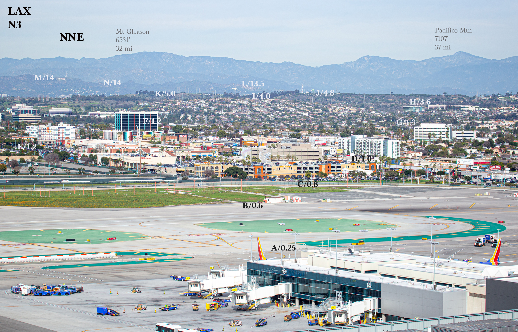
LAX N3 NNE to NE
A/0.25 miles Far end of Terminal 1
B/0.6 miles Small orange and white shacks next to runway
C/0.8 miles Wide parking garage next to In-N-Out
D/1.0 mile 5-story white apartment building along Sepulveda Expressway at La Tijera
E/1.2 miles White 6-story apartment building at Sepulveda and Manchester
F/1.2 miles B&W 10-story Medical Plaza Building, Sepulveda and Manchester
G/1.3 miles 5-story white office building, La Tijera and Bleriot
H/3.6 miles 5-story white office buildings, La Cienega and Slauson
I/4.0 miles Ladera Heights residential housing tract
J/4.8 miles Light blue water tower and tall radio tower on ridge, Baldwin Hills, elev. 510’
K/5.0 miles Electricity transmission towers on ridge top, Baldwin Hills
L/13.5 miles Griffith Observatory, elevation 1100’
M/14 miles Hollywood sign
N/14 miles Mount Hollywood, elev. 1622’
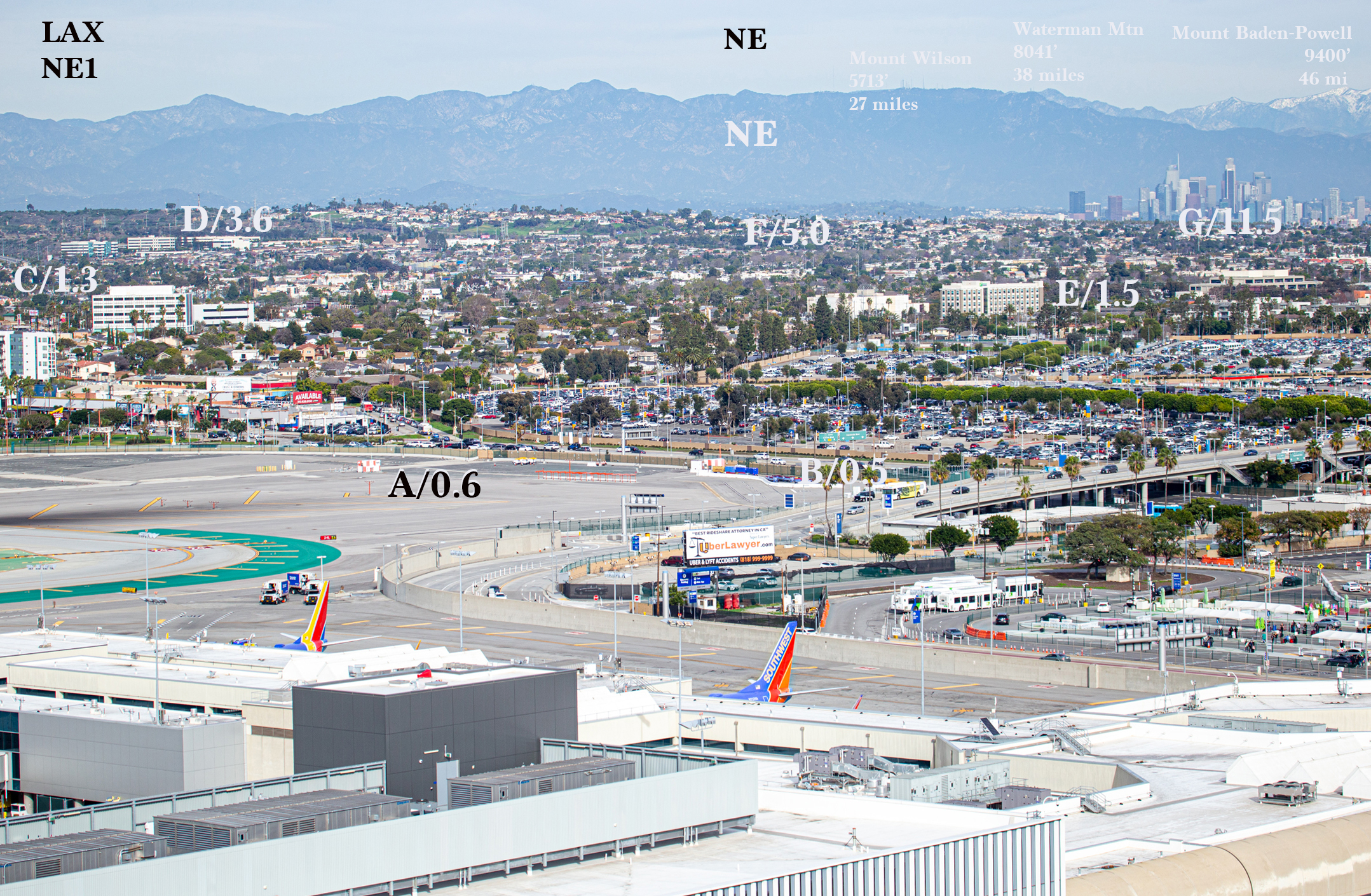
LAX NE1 NE
A/0.6 miles orange and white box at east end of runway near Sepulveda
B/0.5 miles row of tall palm trees along LAX entrance ramp
C/1.3 miles 5-story white office building, La Tijera and Bleriot
D/3.6 miles 5-story white office buildings, La Cienega and Slauson
E/1.5 miles 6-story Holiday Inn Express at Manchester and Airport Blvd.
F/5.0 miles Ridgeline in Windsor Hills area right behind Holiday Inn Express
G/11.5 miles Downtown Los Angeles skyline
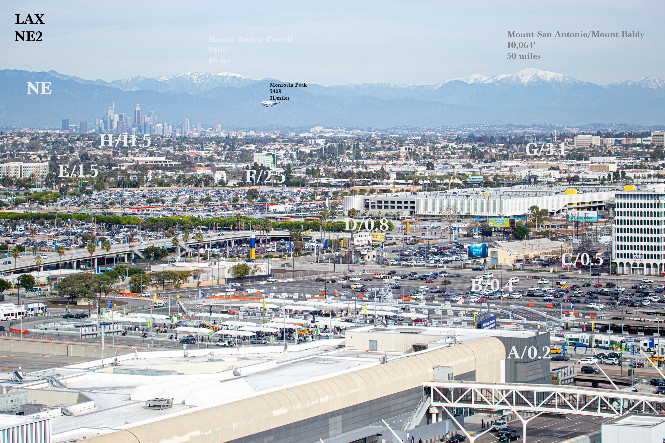
LAX NE2 NE-ENE
A/0.2 miles Pedestrian bridge from Terminal One
B/0.4 miles Large parking lot
C/0.5 miles 9-story white COVID TEST building on Sepulveda
D/0.8 miles Large 3-story white structure around 96th and Jenny
E/1.5 miles 6-story Holiday Inn Express at Manchester and Airport Blvd.
F/2.5 miles Green & white 6-story Extra Space Storage building near 405 and Florence
G/3.1 miles Cluster of 5-to-7-story buildings in Inglewood, white and brown
H/11.5 miles Downtown L.A. skyline
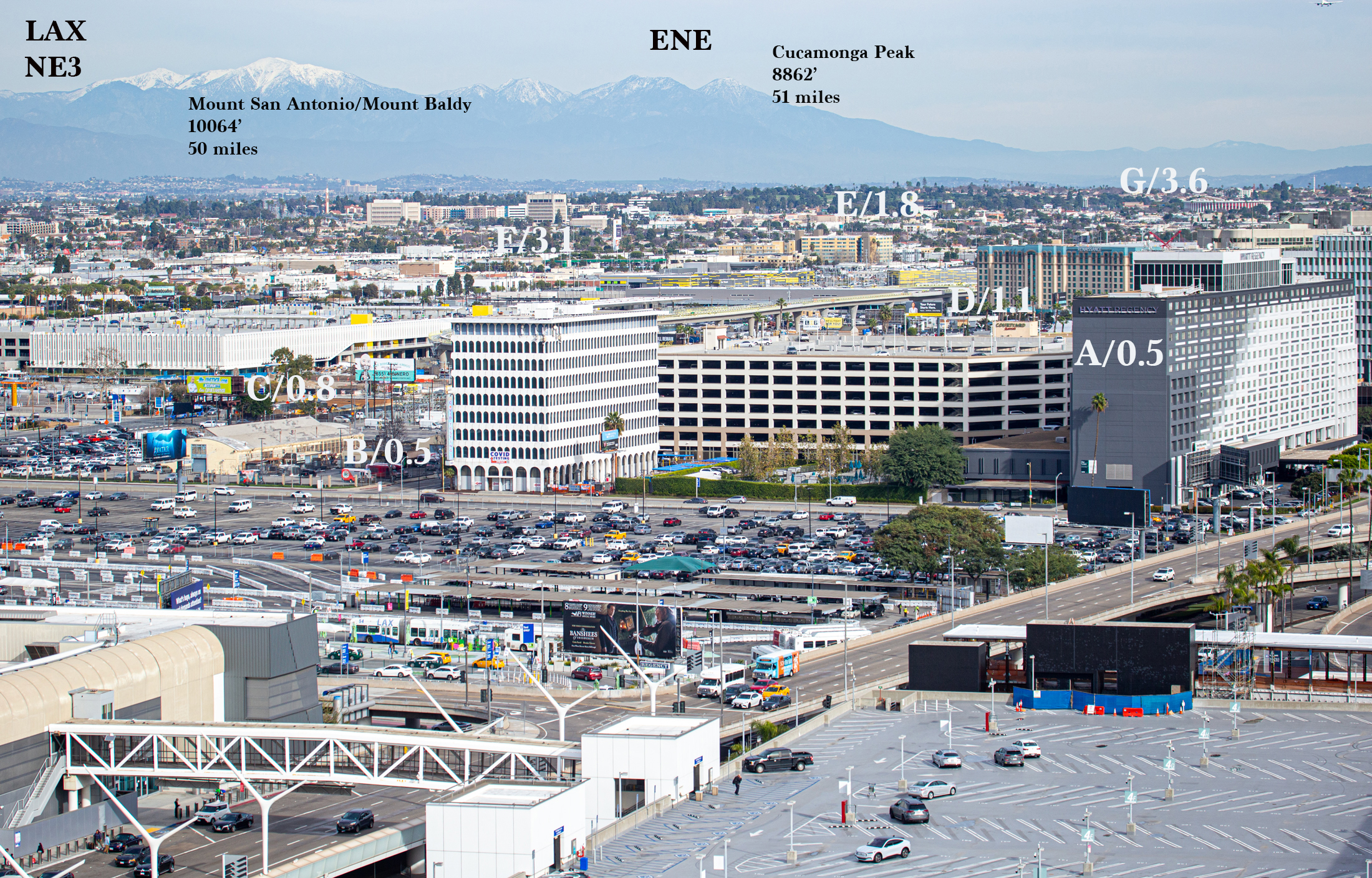
LAX NE3 ENE
A/0.5 miles Solo tall palm tree adjacent to west end of Hyatt Hotel (just under 0.5 miles)
B/0.5 miles 9-story white COVID TEST building on Sepulveda
C/0.8 miles Large 3-story white structure around 96th and Jenny
D/1.1 miles 10-story Renaissance Hotel with blue trim along top (Airport and 96th)
E/1.8 miles 8-story yellow apartment building at Hindry and Arbor Vitae
F/3.1 miles Cluster of 5-to-7-story buildings in Inglewood, white and brown
G/3.6 miles Inglewood Forum
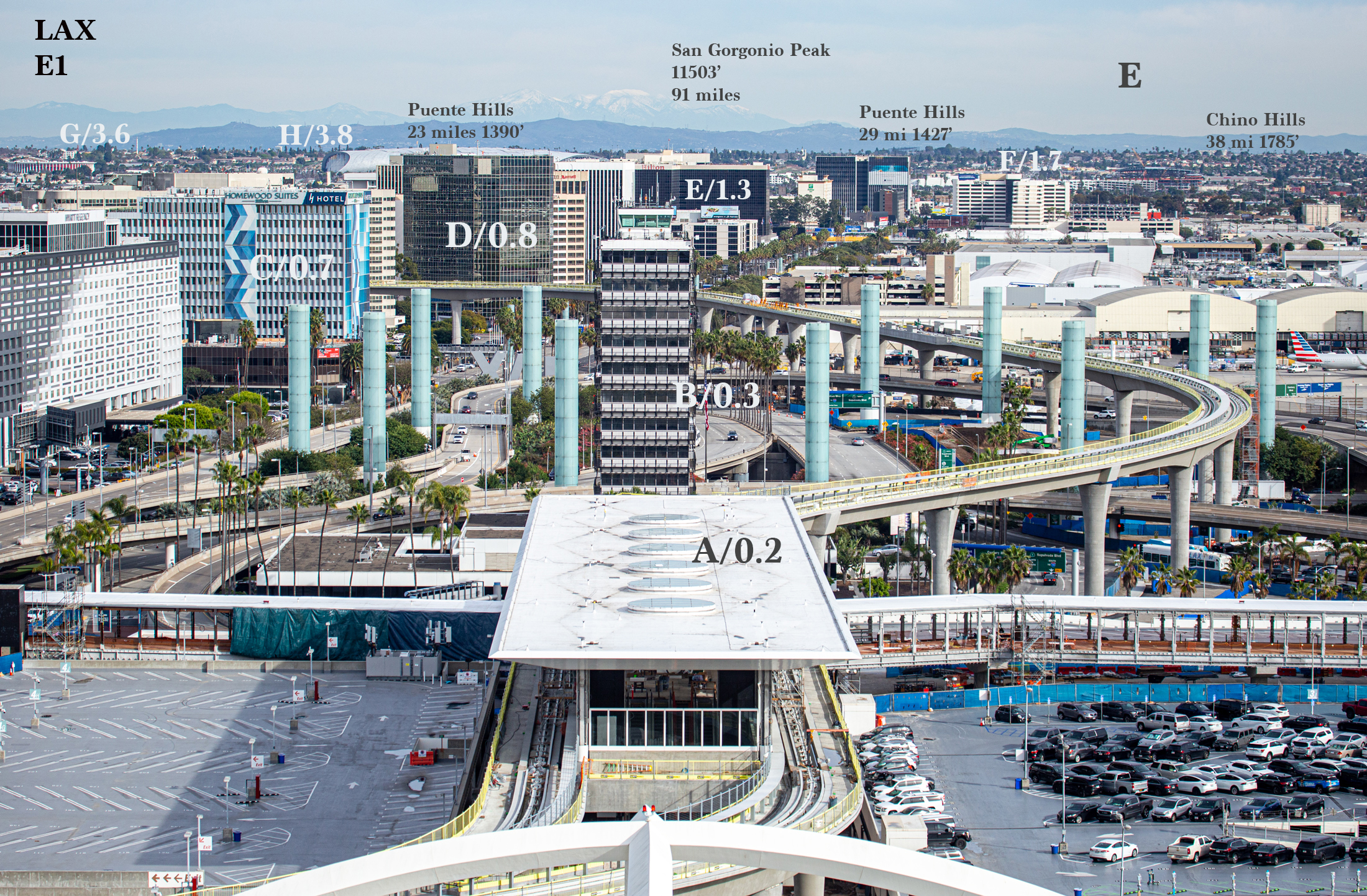
LAX E1 E-ESE
A/0.2 miles Platform roof for rail terminal
B/0.33 miles Old LAX control tower
C/0.7 miles White and blue Homewood Suites Hotel on Century Blvd.
D/0.8 miles Large and tall, black Concentra Urgent Care
E/1.3 miles Black Hilton Hotel with red Hilton sign right above old control tower
F/1.7 miles White and black Westin Hotel
G/3.6 miles Inglewood Forum (Manchester and Prairie)
H/3.8 miles Silver roof of SoFi Football Stadium
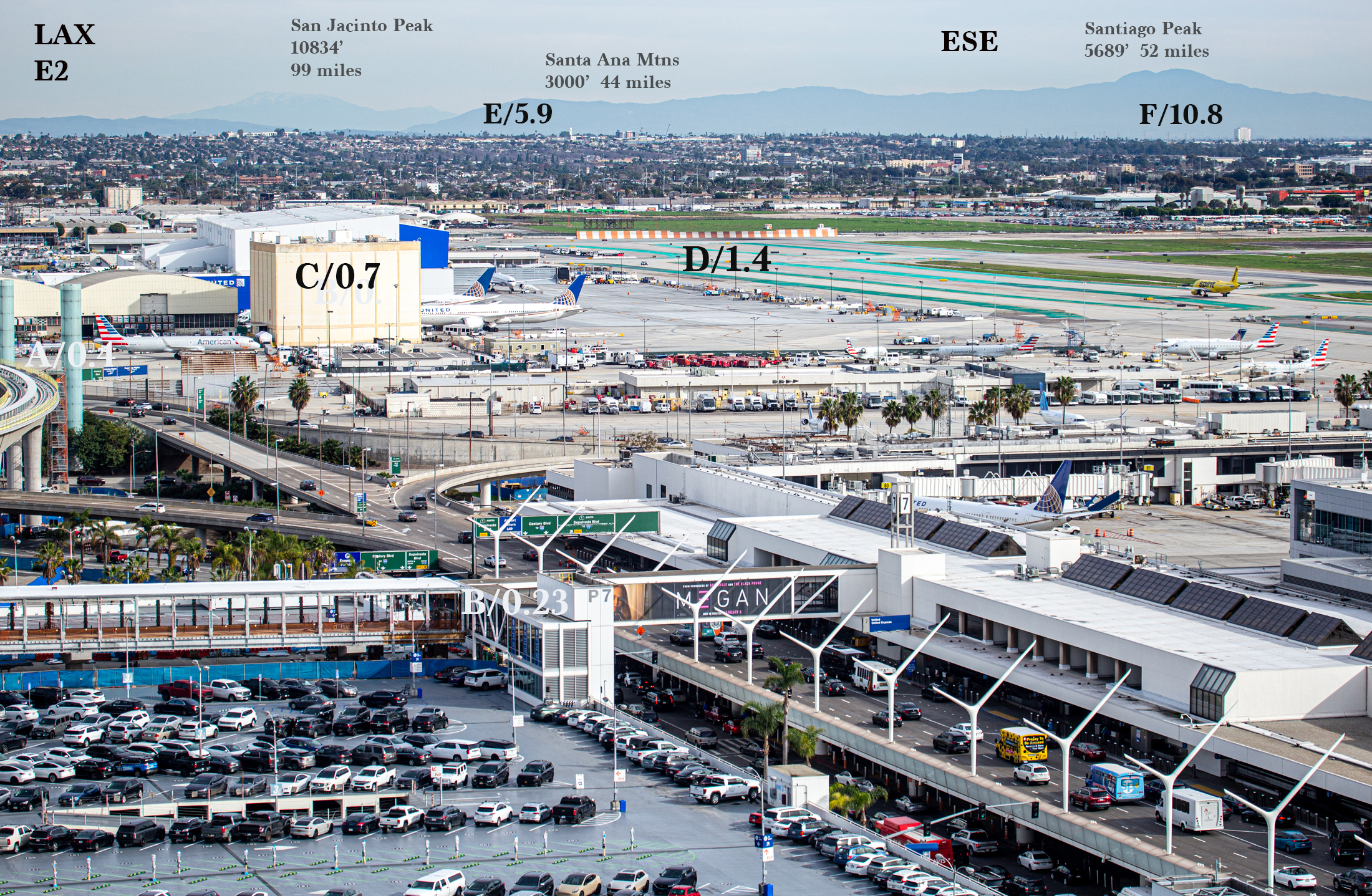
LAX E2 ESE
A/0.4 miles Right edge of curve of Elevated Rail
B/0.23 miles P7 Stairwell
C/0.7 miles Tall structure on tarmac, light cream colored
D/1.4 miles Orange and white blast fence at east end of runway
E/5.9 miles White St. Francis Church Bell Tower (Imperial Hwy and Normandie)
F/10.8 miles White Compton Courthouse square building (13-story, Compton & Willowbrook)
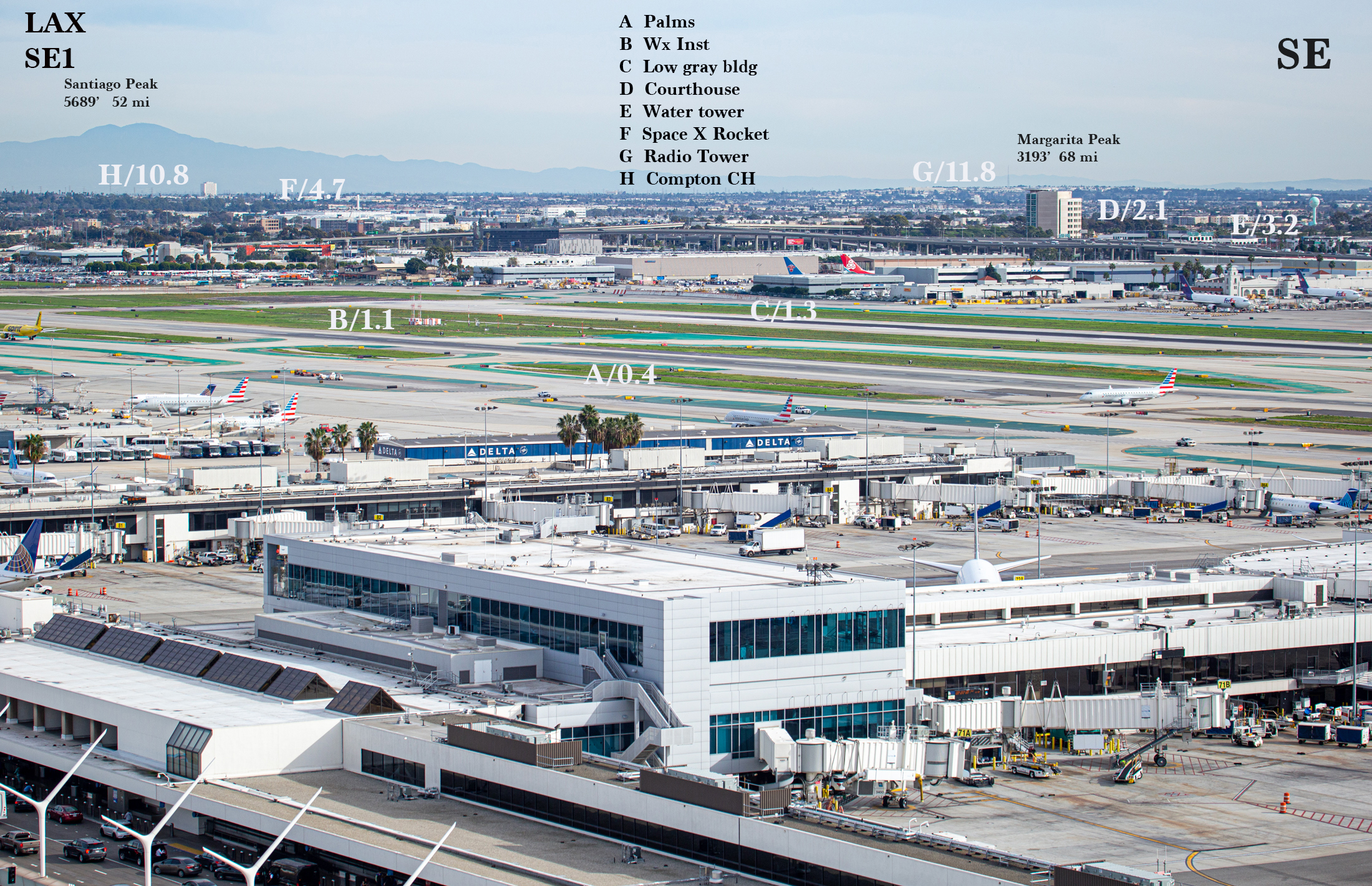
LAX SE1 ESE-SE
A/0.4 miles Four tall palm trees in front of Delta building
B/1.1 miles White and Orange weather instrumentation
C/1.3 miles Low gray building
D/2.1 miles Airport Courthouse Building (8-stories)
E/3.2 miles Blue Hawthorne water tower
F/4.7 miles White SpaceX Rocket Tower (near Hawthorne AP)
G/11.8 miles Radio Transmission Tower on Dominguez Hills
H/10.8 miles Compton Courthouse, white square bldg at Compton & Willowbrook
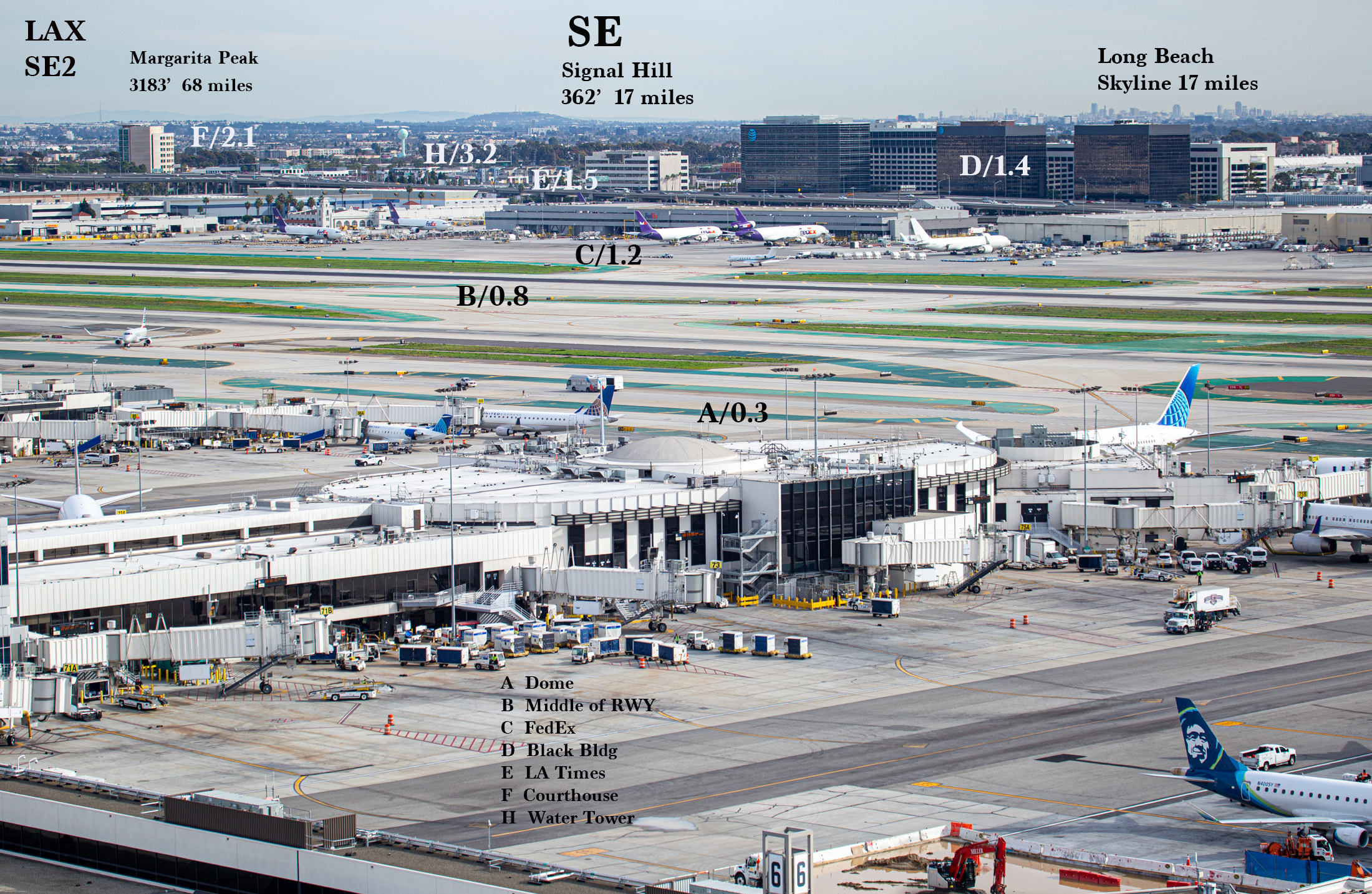
LAX SE2 SE
A/0.3 miles Dome on Terminal 7 (United)
B/0.8 miles Middle of runways to the southeast
C/1.2 miles FedEx Building
D/1.4 miles Two large black buildings (12-stories) on Imperial Hwy
E/1.5 miles Light-colored L.A. Times building (6 stories) on Imperial Hwy
F/2.1 miles Airport Courthouse (8 stories)
H/3.2 miles Blue Hawthorne water tower
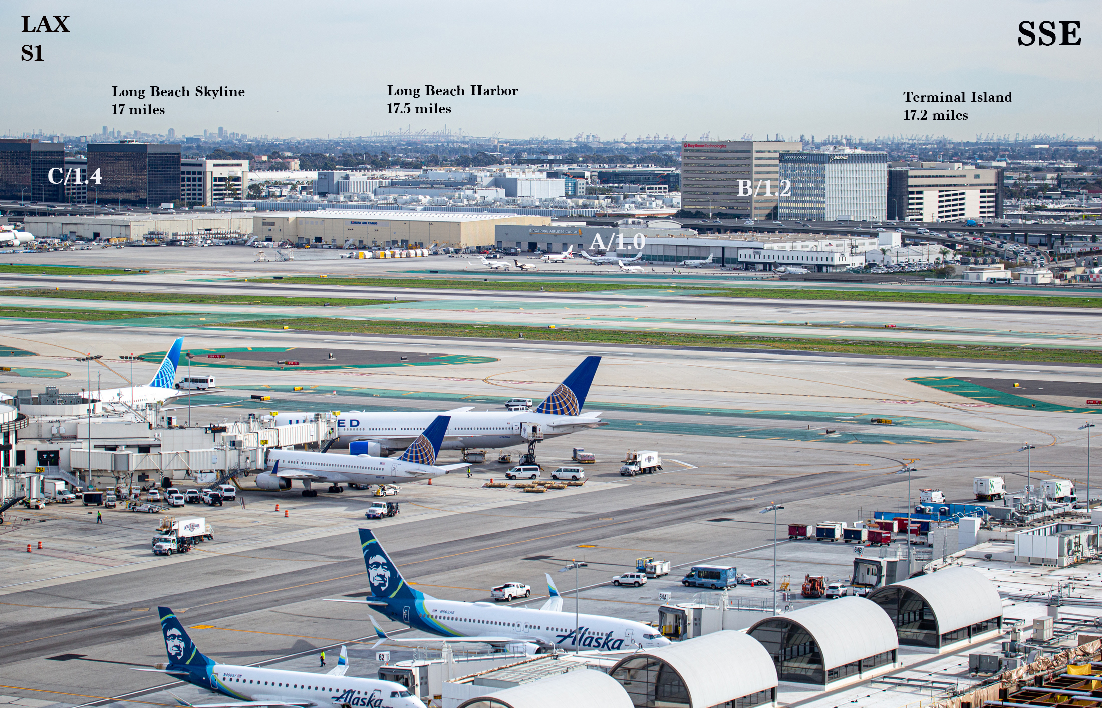
LAX S1 SE-SSE
A/1.0 miles Low gray Singapore Airlines building
B/1.2 miles Tall Raytheon and Boeing buildings (10 stories, Imperial & Hughes)
C/1.4 miles Black office building (12 stories, Imperial and Nash)
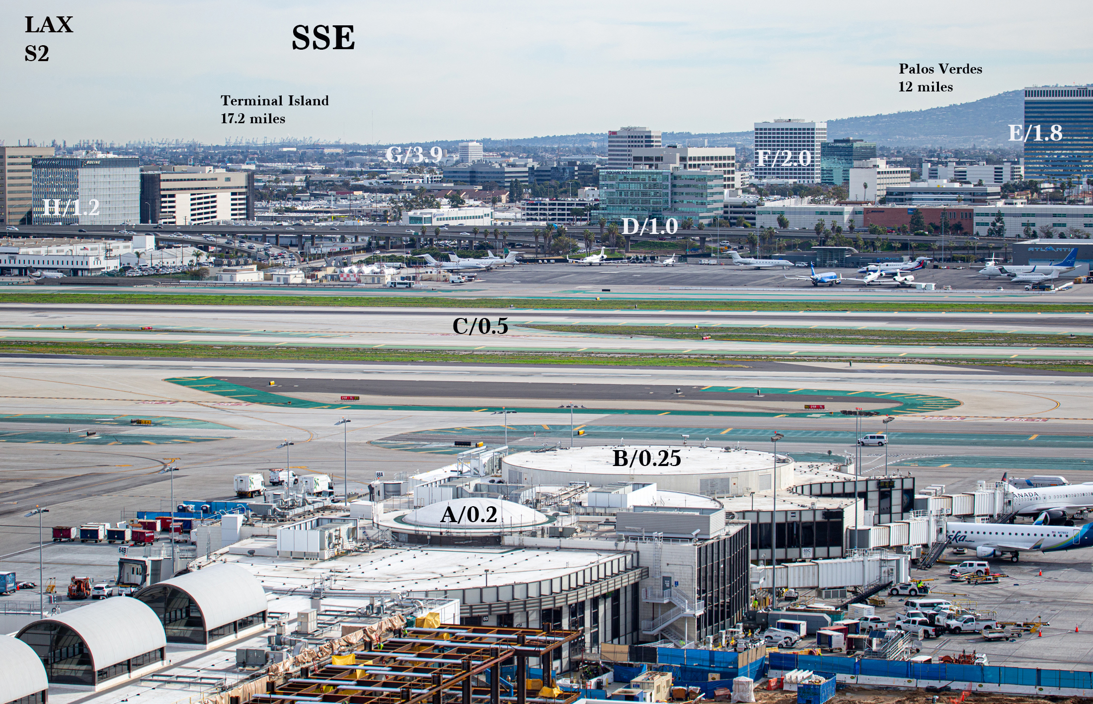
S2 SSE
A/0.2 miles (1150’) Dome on Terminal 6
B/0.25 miles (1380’) Round top, end of Terminal 6
C/0.5 miles Middle of runway just beyond Terminal 6
D/1.0 mile Aqua Glass/Square Enix Building at Imperial and Sepulveda
E/1.8 miles Reflective 23-story building with white top (Grand and PCH)
F/2.0 miles White and black 14-story building (Continental and El Segundo)
G/3.9 miles Black and white 12-story Northrup Grunman building (Redondo & Marine)
H/1.2 miles Boeing Building (10 stories, on Imperial Hwy)
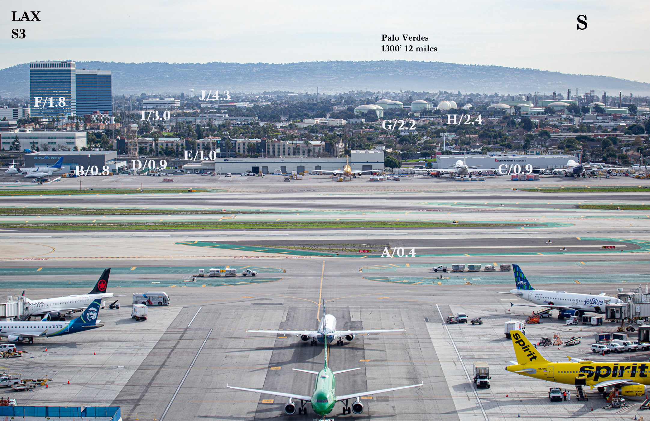
LAX S3 SSE-S
A/0.4 miles Red airfield marker 25R7L (2150 feet away)
B/0.8 miles Gray Atlantic building (4220’)
C/0.8 miles Light gray Qantas building
D/0.9 miles Tan—colored tower with white top
E/1.0 mile Embassy Suites along Imperial Hwy.
F/1.8 miles 23-story reflective/white top building (Grand & PCH, 1.9 miles to next one)
G/2.2 miles closest green refinery tank
H/2.4 miles White dome next to green tanks
I/3.0 miles White and black WEWORK building, 6 stories
J/4.3 miles White water tower at 8th and Rowell in Manhattan Beach
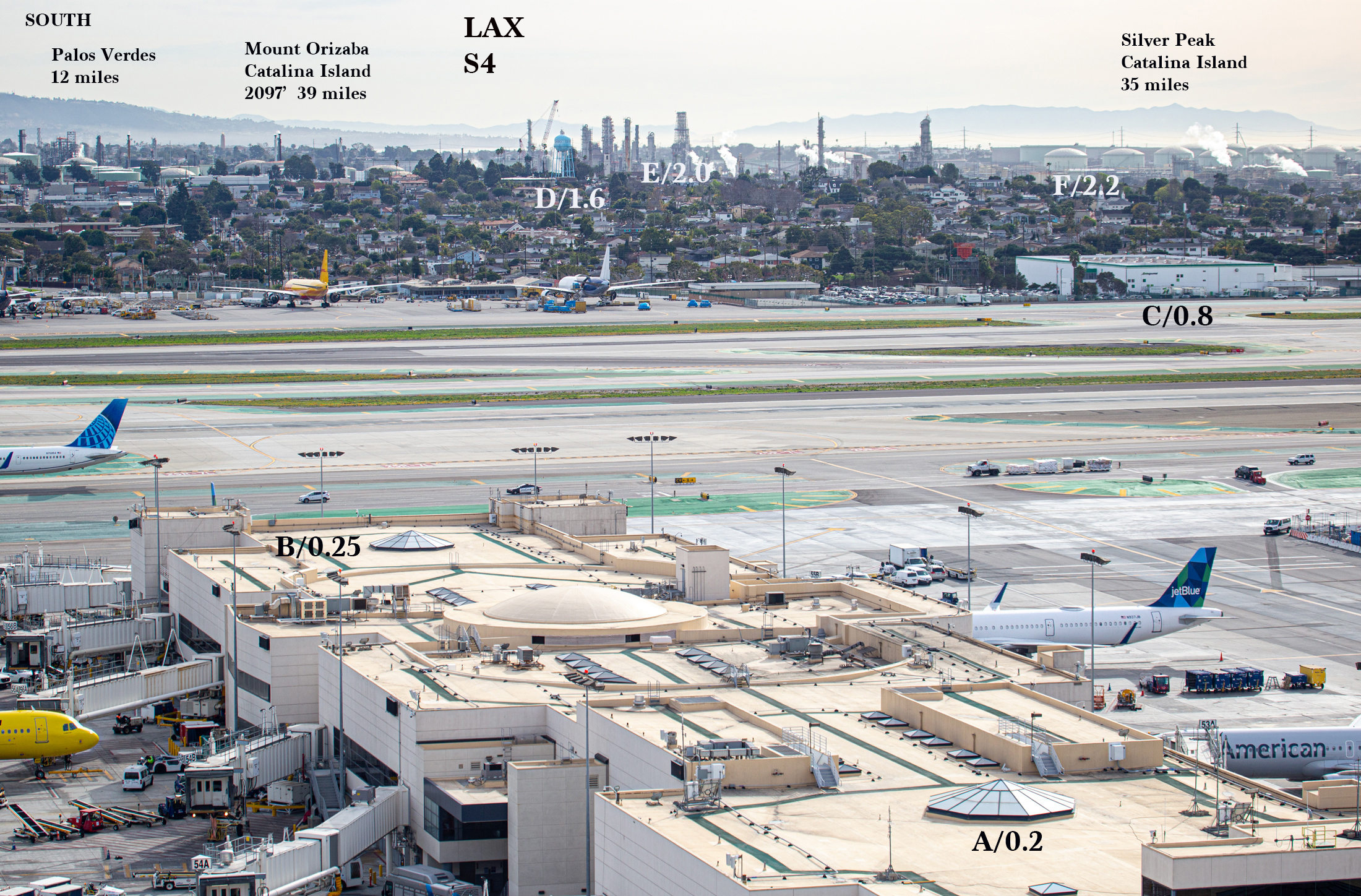
LAX S4 S-SSW
A/0.2 miles Closer diamond-shaped glass top on T5 roof (850 feet away)
B/0.25 miles Diamond-shaped glass top at end of Terminal 5 (1400 feet away)
C/0.8 miles Gate Gourmet building/light green
D/1.6 miles Blue El Segundo Water Tower at Maryland & Grand
E/2.0 miles Tall refinery derricks
F/2.2 miles Green refinery tanks
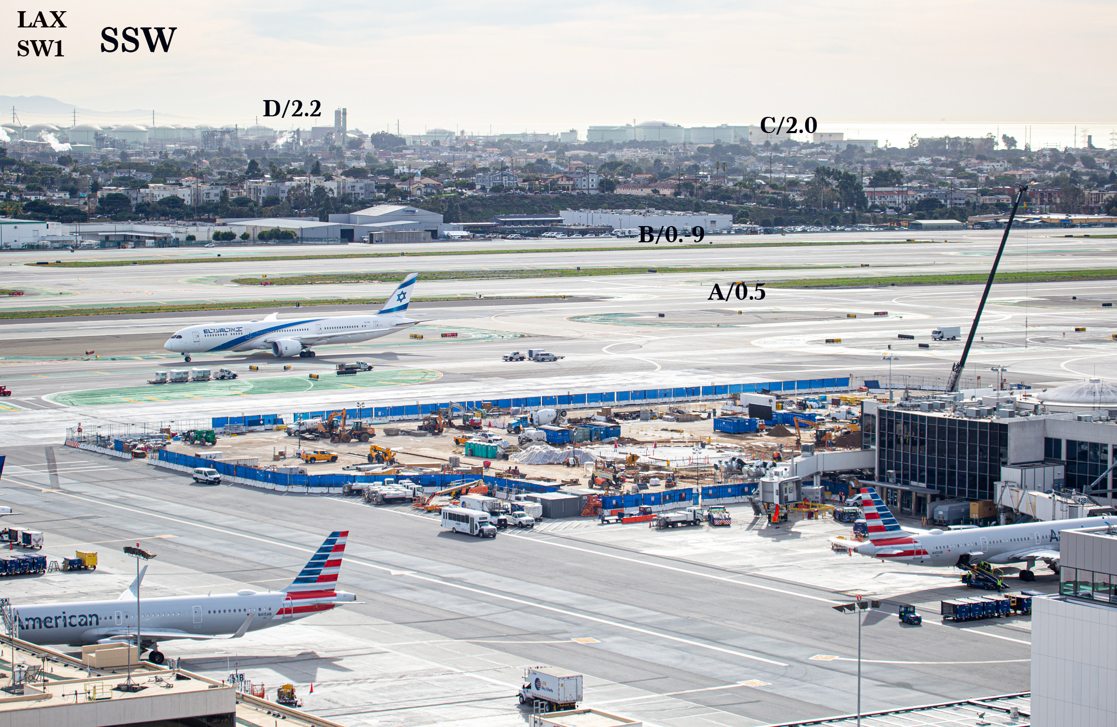
LAX SW1 SSW-SW
A/0.5 miles Middle of Runways to SW
B/0.9 miles Sky Chefs building (white)
C/2.0 miles Green tanks at refinery
D/2.2 miles Tall refinery towers
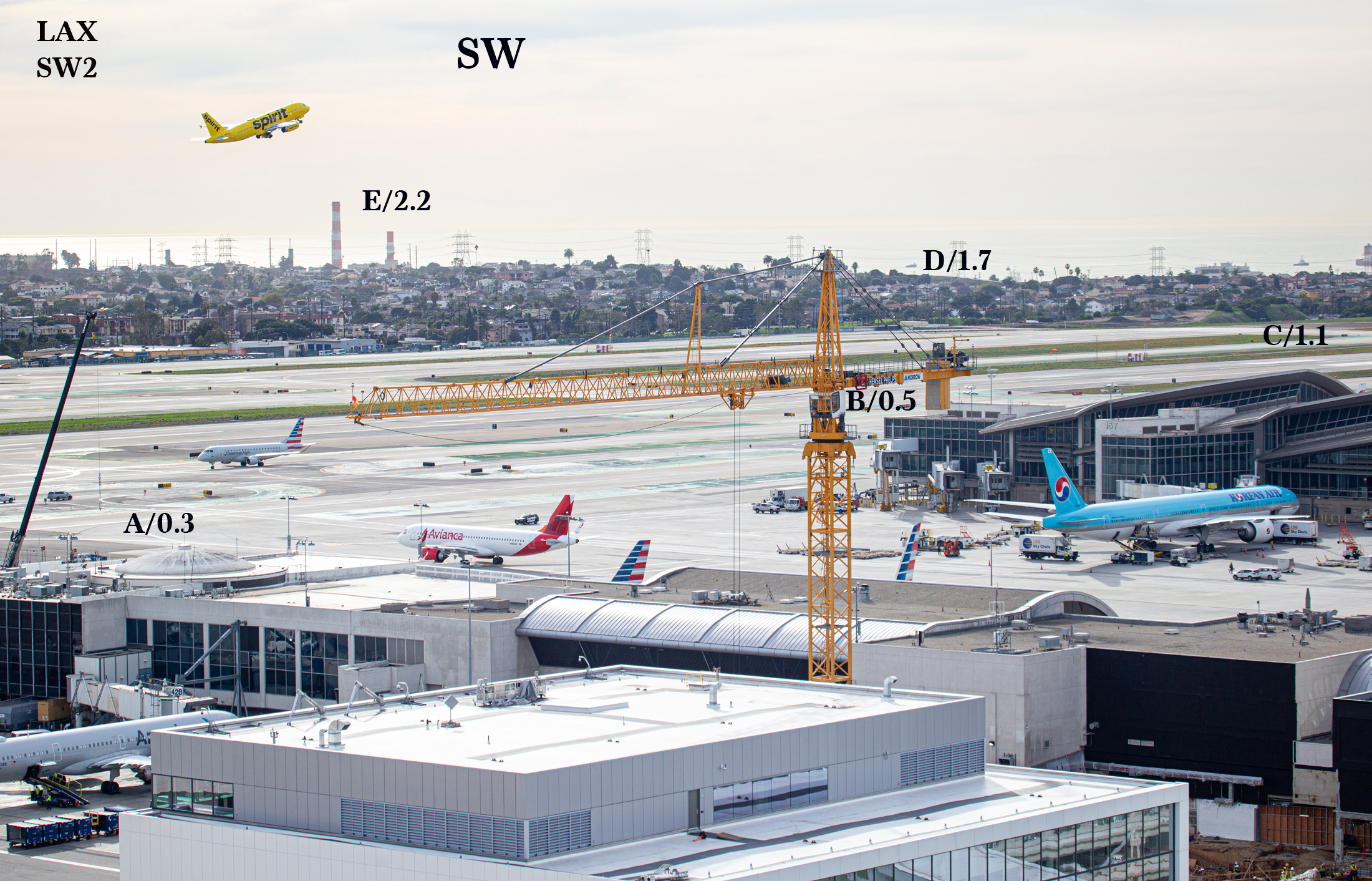
LAX SW2 SW-WSW
A/0.3 miles 1545’ Round glass dome Terminal 4
B/0.5 miles 2500’ South end of Tom Bradley Terminal
C/1.1 miles West end of south runway
D/1.7 miles Bluff to southwest
E/2.2 miles Red and white Twin Stacks at Hyperion Water Treatment Plant
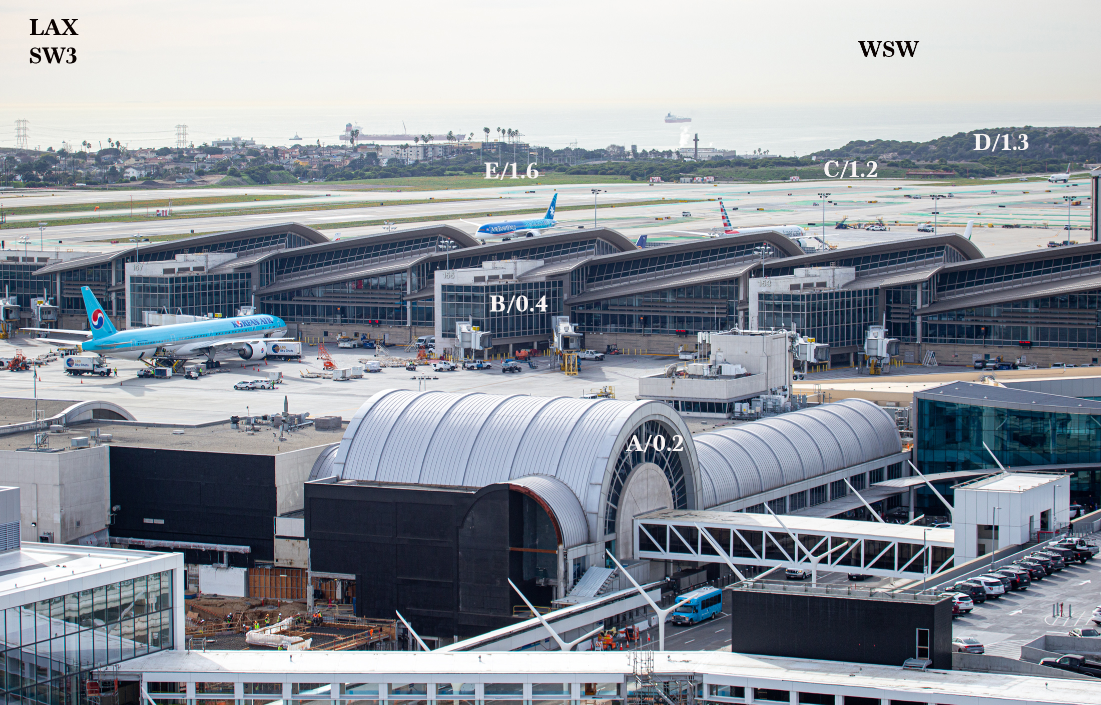
LAX SW3 WSW
A/0.2 miles 1130’ Arch-shaped entrance to Terminal 4
B/0.4 miles 2100’ Tom Bradley Terminal to WSW
C/1.2 miles West end of south runway
D/1.3 miles Bluff to the WSW
E/1.6 miles Palm trees on bluff against the ocean
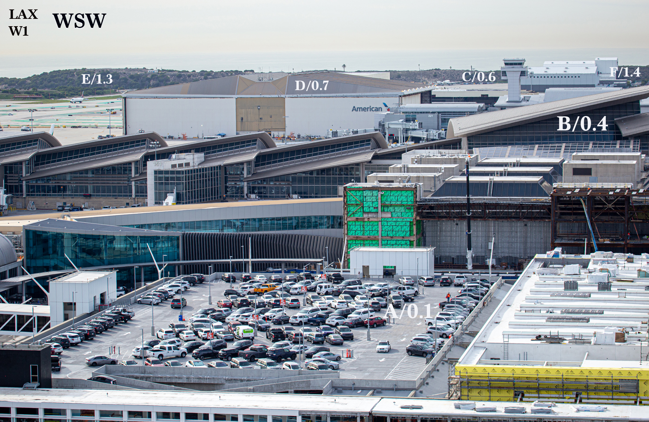
LAX W1 WSW-W
A/0.1 miles 500’ Middle of Parking lot to WSW
B/0.4 miles 1920’ Tom Bradley terminal to west
C/0.6 miles Control Tower behind TB Terminal to west
D/0.7 miles American Airlines building
E/1.3 miles Bluff
F/1.4 miles White Delta building
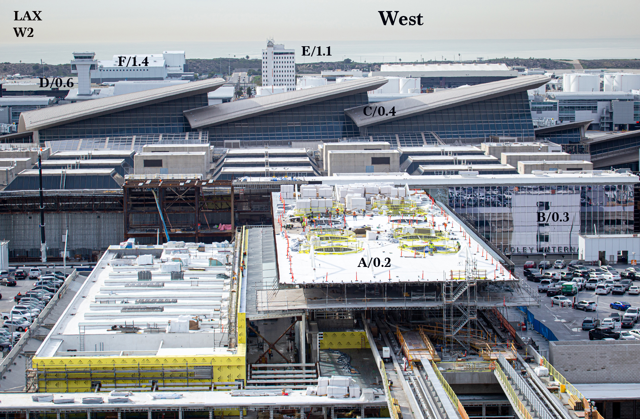
LAX W2 W
A/0.2 miles Near side of light rail platform roof
B/0.3 miles 1350’ Front of Tom Bradley Terminal along World Way
C/0.4 miles Glass side of Tom Bradley Terminal beneath slanted roof
D/0.6 miles Control tower behind TB Terminal
E/1.1 miles 10-story white building
F/1.4 miles White Delta Tech ops building
LAX W3 W-WNW
A/0.2 miles Middle of parking structure P3
B/0.3 miles 1350’ Front of Tom Bradley Terminal along World Way
C/0.7 miles 3500’ 200-numbered terminal
D/1.0 mile 5300’ White fuel tanks
E/1.6 miles West end of north runway
F/1.9 miles Orange and white blast fence at west end of north runway
G/2.0 miles Bluff behind blast fence
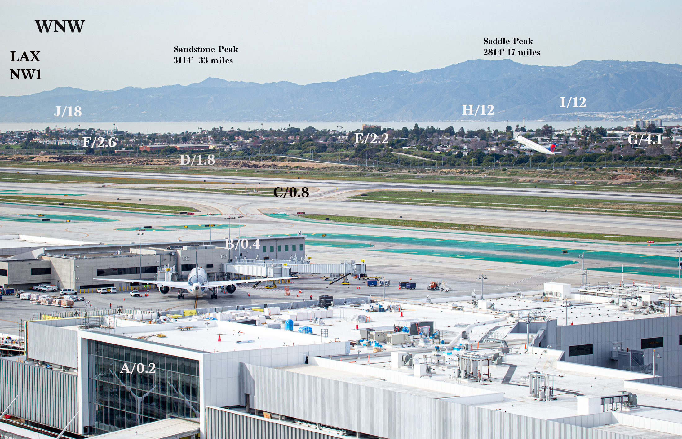
LAX NW1 WNW-NW
A/0.2 miles 930’ Dark glass front of Terminal 3 at walkway over road
B/0.4 miles 2080’ Gates 135 and 137
C/0.8 miles 4450’ Middle of runways and instrumentation
D/1.8 miles St. Bernards High School, ruddy brick 2-story with light-toned roof
E/2.2 miles Top of 7-story brown Homefed Bank building at Manchester and Falmouth
F/2.6 miles Hilltop, homes and tall palm trees at Playa del Rey, just beyond end of runway
G/4.1 miles Large 14-story apartment building in Marina del Rey (Washington & Via Dolce)
H/12 miles Coastline at Topanga Beach
I/12 miles Hillside at Pacific Palisades
J/18 miles Malibu Beach and Pepperdine (with tall white steeple tower)
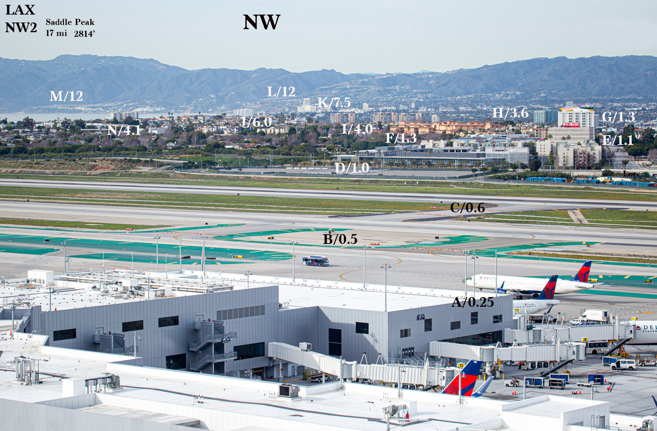
LAX NW2 NW
A/0.25 miles 1340’ End of Terminal 3 building
B/0.5 miles 2450’ Red runway marker along taxiway
C/0.6 miles 3250’ Red runway marker between runways
D/1.0 mile 3 Flag poles at LAX Police station
E/1.1 miles 6-story white Otis College building
F/1.3 miles Loyola complex, 4-story brown/ruddy colored
G/1.3 miles 12-story white Hotel June (Lincoln and Manchester)
H/3.6 miles 17-story apartment building, aqua and white (Lincoln and Marina Pt Way)
I/4.0 miles Three 15-story apt. buildings, tan colored (Admiralty Way, Marina del Rey)
J/6.0 miles 17-story white building in Santa Monica (Hill and Neilson)
K/7.5 miles 100 Wilshire Building at 2nd St., 21-story, Santa Monica (B&W)
L/12 miles Slopes of Pacific Palisades
M/12 miles West end of Pacific Palisades
N/4.1 miles Large 14-story apartment building in Marina del Rey (Washington and Via Dolce)
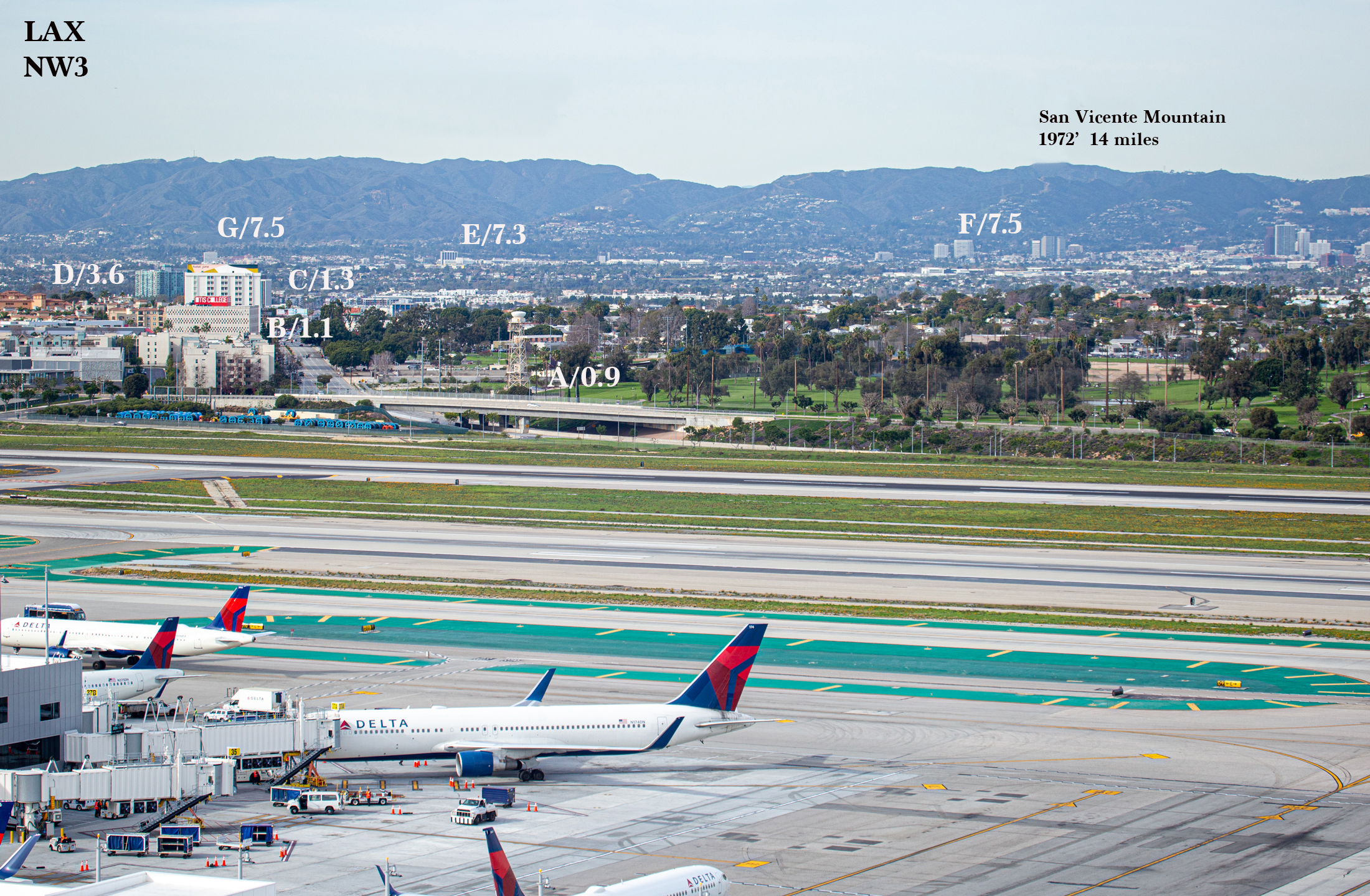
LAX NW3 NW-NNW
A/0.9 miles Aviation radar tower with white top, and golf course
B/1.1 miles 6-story white Otis College building
C/1.3 miles 12-story white Hotel June (Lincoln and Manchester)
D/3.6 miles 17-story apartment building, aqua and white (Lincoln and Marina Pt Way)
E/7.3 miles Medical Center of Santa Monica (S.M. and 20th). 12-story B&W building
F/7.5 miles Santa Monica and Sepulveda 15-story buildings, white
G/7.5 miles 15-story white bldg behind June Hotel (Arizona and 15th in Santa Monica)
Leave a Reply
You must be logged in to post a comment.