A potent storm swept through Southern California on Tue, March 21. On the next day, energetic cyclonic WSW flow continued over Los Angeles County above the cool and moist air behind Tuesday’s front. An isolated storm cell developed in the Compton area (south of downtown Los Angeles) around 10:30 a.m. PDT (1730Z) and moved to the northeast. This storm showed some rotation and it spawned an EF1 tornado while over Montebello, near Washington and Maple Streets (two miles south of the center of Montebello. The tornado occurred around 11:20 a.m. PDT (1820Z), did not last for a very long time (perhaps only a minute or two), and it did some significant damage in an industrial section of town. Plenty of video of the tornado can be found on YouTube.
Crazy Twitter image of the storm here!
This blog entry is made to share some of the weather maps and weather data that I saved for the event.
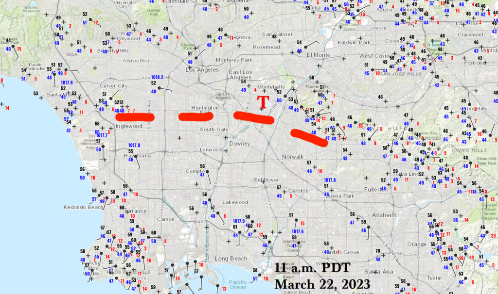
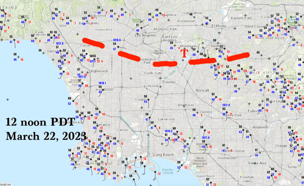
The two surface maps of the L.A. Basin and vicinity above are for 11 a.m. (18Z) and noon PDT (19Z). The red “T” is the location of the Montebello tornado, which occurred at 11:20 a.m. PDT. A dashed red line was drawn which roughly shows where (mostly) southerly winds come up against (mostly) moist easterly winds. The storm produced the tornado in close proximity to this wind-shift boundary. South of the boundary, in the southerly winds, temperatures were in the upper 50s to near 60F and dew points were in the mid 40s (by noon). North of the boundary, in the easterly winds, temperatures were lower, in the low-mid 50s. Dew points were in the high 40s, a little higher than the dew points south of the boundary. Relative humidity at the surface was quite a bit higher just north of the boundary. This local meteorological situation is similar to “warm front” setups in the central and eastern parts of the country which sometimes are associated with tornadoes. It is very doubtful that the little storm cell would have produced a tornado had this east-west boundary not existed.
Let’s share some local weather data from this Wednesday morning.
Below are the METARS and SPECIS observations from the downtown Los Angeles station (KCQT) from 1547Z (8:47 a.m. PDT) to 1930Z (12:30 p.m. PDT). The earliest ob is at the bottom. This station is about ten miles west of the tornado location in Montebello.
| SPECI KCQT 221930Z AUTO 00000KT 2SM RA SCT036 BKN047 OVC060 12/09 A3007 RMK AO2 VIS 1 1/4V4 RAB10 P0002 T01170089 |
| KCQT 221847Z AUTO VRB04KT 10SM FEW038 SCT065 BKN100 12/08 A3008 RMK AO2 RAE1759 SLP186 P0002 T01220083 |
| METAR KCQT 221747Z AUTO 10005KT 3SM RA BR FEW020 BKN038 OVC049 11/09 A3007 RMK AO2 SLP182 P0003 60008 T01110089 10117 20083 51026 |
| KCQT 221744Z AUTO 10005KT 3SM RA BR FEW020 BKN040 OVC055 11/09 A3007 RMK AO2 P0003 T01110089 |
| KCQT 221739Z AUTO VRB05KT 2 1/2SM -RA BR FEW027 BKN044 OVC050 11/09 A3007 RMK AO2 P0002 T01110089 |
| METAR KCQT 221647Z AUTO VRB03KT 4SM -RA BR FEW025 SCT038 OVC048 11/08 A3005 RMK AO2 RAB13 SLP175 P0001 T01060083 |
| METAR KCQT 221547Z AUTO VRB04KT 10SM FEW026 BKN039 11/08 A3003 RMK AO2 SLP170 T01060078 |
The tornado, at 1820Z, occurred between the 1747Z and 1847Z METARs for Los Angeles. The station is rather wind-protected, but it did show an east wind at 5 knots at 1747Z. Cloud bases were as low 2000 feet and the temp/dew pt spread of 52F/48F was quite small. A rain shower ended at 1759Z according to the 1847Z observation.
Below are the observations from the Los Alamitos Army Airfield (KSLI) from 1555Z (8:55 a.m. PDT) to 1952Z (12:52 p.m. PDT). This airport station is a little east of Long Beach and is approximately 17 miles south of the location of the tornado this day. Unlike the automatic station for Los Angeles, KSLI has human observers.
| SPECI KSLI 221952Z 21012KT 9SM -RA FEW027 BKN033 BKN060 BKN095 14/08 A3006 RMK AO2A RAB52 SLP182 |
| METAR KSLI 221855Z 19011G16KT 10SM BKN030 BKN065 15/09 A3005 RMK AO2A SLP179 T01500089 |
| METAR KSLI 221755Z 18010KT 10SM FEW025 SCT060 14/09 A3004 RMK AO2A RAE05DZB05E07 SLP176 P0000 60002 T01440086 10144 20079 52023 |
| SPECI KSLI 221707Z 25005KT 10SM FEW003 SCT025 SCT040 BKN060 12/10 A3003 RMK AO2A RAE05DZB05E07 SLP172 |
| METAR KSLI 221655Z 00000KT 7SM -RA FEW003 BKN027 BKN034 BKN048 BKN060 12/09 A3002 RMK AO2A RAB43 SLP169 P0001 T01160086 |
| SPECI KSLI 221643Z 00000KT 8SM -RA SCT029 BKN035 BKN060 11/09 A3002 RMK AO2A RAB43 SLP169 |
| METAR KSLI 221555Z 09004KT 8SM FEW010 SCT027 BKN038 BKN060 11/09 A3000 RMK AO2A RAE1456DZB1456E1459DZB26E43 SLP162 P0001 T01100091 |
The observer at KSLI did not include any CBs or thunderstorms in the observations. Note the gusty southerly winds at 1855Z. The dew point was as high as 50F at 1707Z.
Similarly, here are the obs at LAX, about 16 miles WSW of the tornado location. Southerly winds developed rather abruptly between 1753Z and 1807Z.
| METAR KLAX 221953Z 21015G22KT 4SM -RA BR BKN032 BKN070 OVC090 13/08 A3008 RMK AO2 RAB50 SLP184 P0000 T01330083 |
| METAR KLAX 221853Z 18013KT 10SM SCT034 BKN042 BKN100 15/07 A3006 RMK AO2 SLP179 T01500072 |
| SPECI KLAX 221807Z 17012KT 10SM SCT019 SCT028 BKN036 14/09 A3006 RMK AO2 SCT028 V BKN T01440094 |
| KLAX 221753Z COR 23003KT 7SM SCT024 BKN029 BKN038 14/11 A3005 RMK AO2 RAE40 SLP177 P0002 60011 T01390106 10139 20089 51023 |
| METAR KLAX 221653Z 09005KT 7SM -RA BKN024 BKN032 OVC043 11/09 A3004 RMK AO2 SLP172 P0004 T01110089 |
| SPECI KLAX 221628Z 10007KT 6SM -RA BR SCT022 BKN028 OVC060 11/09 A3003 RMK AO2 P0004 T01060089 |
| METAR KLAX 221553Z 09005KT 7SM -RA SCT036 OVC060 11/08 A3002 RMK AO2 RAB47 SLP165 P0000 T01060083 |
El Monte AP is a little less than ten miles northeast of the tornado location in Montebello. Here are the obs from this airport:
| KEMT 221910Z 32004KT 10SM FEW022 SCT032 BKN045 09/07 A3008 RMK TS B1831E1910 |
| METAR KEMT 221845Z 30007KT 280V340 2SM SHRA TSVC SCT010 OVC027 11/07 A3009 RMK TS B1831 |
| METAR KEMT 221832Z 08005KT 5SM TSVC BR FEW010 SCT030 BKN055 11/07 A3008 RMK LGT DSNT SW TS B1831 |
| KEMT 221748Z 06008KT 10SM FEW010 SCT030 BKN055 12/08 A3007 |
| METAR KEMT 221645Z VRB04KT 8SM SCT018 BKN039 10/09 A3006 |
This airport does not have dedicated weather observers, but the air traffic controllers can augment the observations. The El Monte AP obs show thunderstorms at 1832Z (12 minutes after the tornado) and at 1845Z. The wind was east at 5 knots at 1832Z. Lightning is in the remarks on this ob, also. Wind changed to light and from the NW by 1845Z. The storm which caused the Montebello tornado moved over El Monte just 10-20 minutes later.
The hourly observations below are from the CARB station in Pico Rivera. This station is just a couple of miles ENE of the tornado location. Note that the wind around tornado time (11:20 a.m.) was NE at 6 mph.
| Mar 22, 12:00 pm | 53 | 48 | 84 | N | 5 | 1021.37 | 30.05 |
| Mar 22, 11:00 am | 53 | 50 | 87 | NE | 6 | 1020.61 | 30.03 |
| Mar 22, 10:00 am | 50 | 49 | 96 | ENE | 3 | 1020.03 | 30.01 |
| Mar 22, 9:00 am | 48 | 48 | 98 | NE | 2 | 1019.09 | 29.98 |
I checked the nearest WU (WeatherUndergrond) home stations, and found one called Wulfmann South Montebello. It is only 5 blocks or so SSE of the tornado locale. It showed a spike in wind to SSE 12 mph at 11:19 a.m.! Wind was about 6 mph five minutes prior to and after this report.
Okay, that’s enough of the nearby hourly station data. Let’s look at some satellite and radar images.
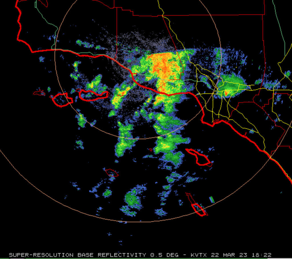
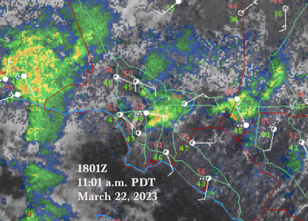
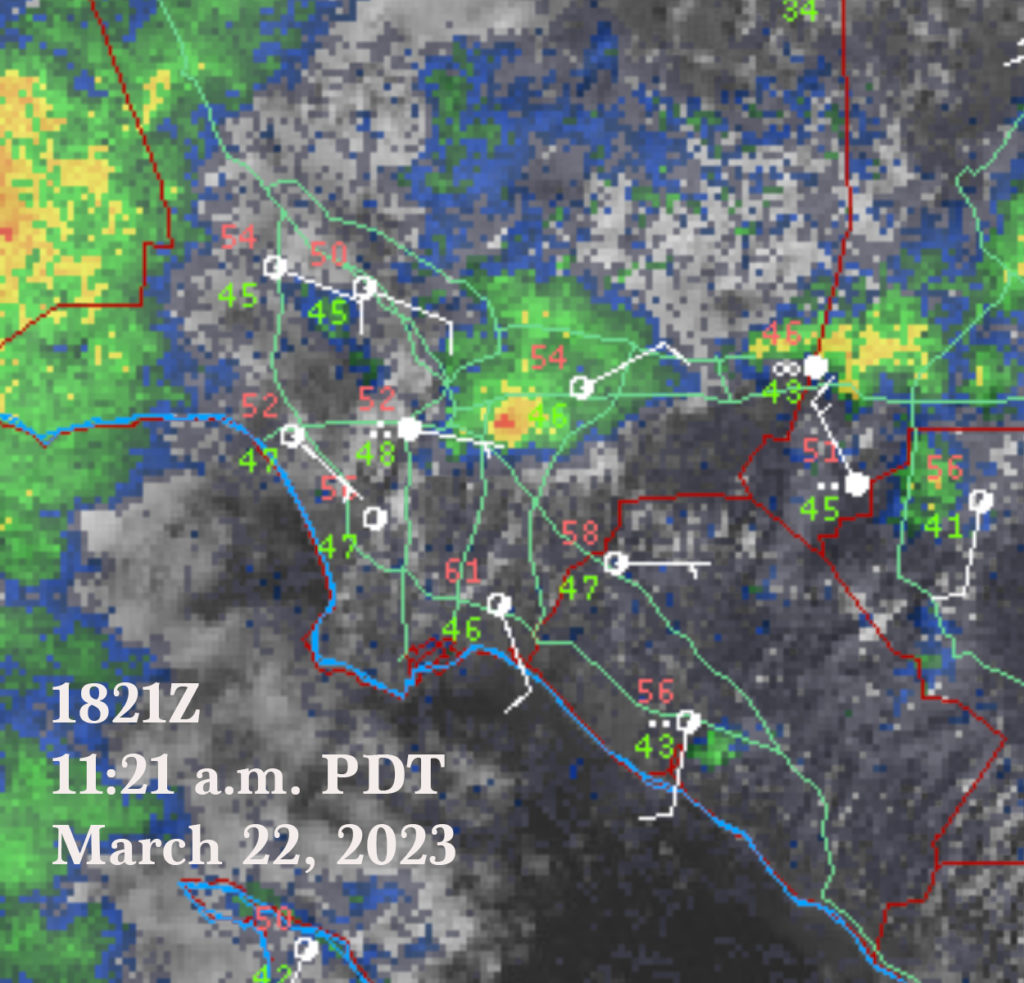
The radar image on the left is from the VTX radar near Ojai in Ventura County, at about tornado time (1822Z). The Montebello storm is close to the right edge, a little more than fifty miles from the radar. Note how isolated the storm is. The next two images provide both visible satellite and radar info, at 1801Z and 1821Z. (The tornado was at 1820Z.). A circular red core develops at 1821Z. Again, note the isolated nature of the cell, and the abundant sunshine west and south and east of the storm. It appears that the storm updraft moved northeastward from the area with sunshine and southerly winds, and then produced the tornado as it interacted with the boundary where cooler air and easterly winds prevailed.
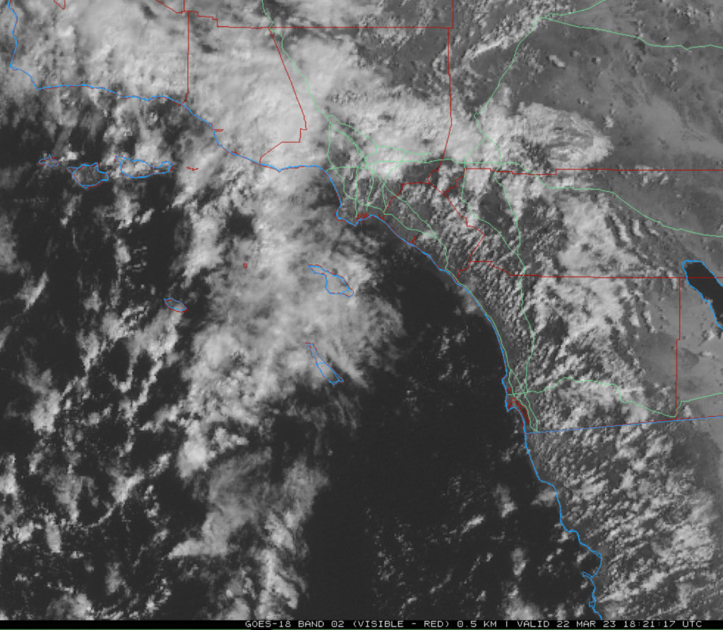
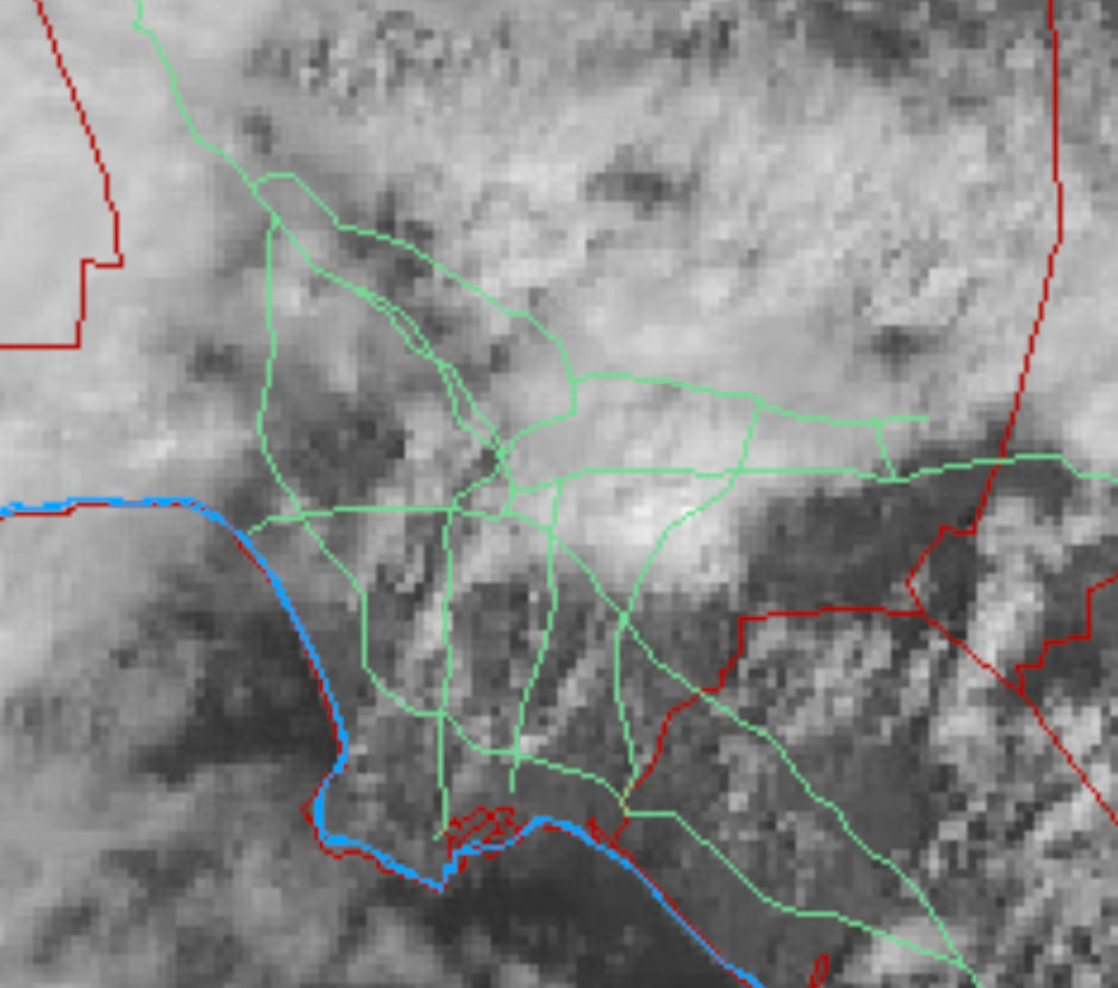
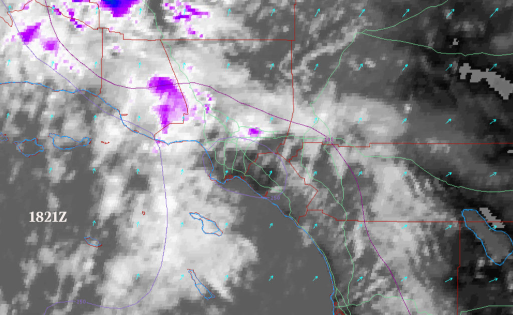
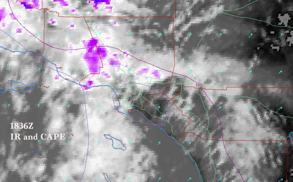
The first image above is the visible satellite image for 1822Z, and the second image is a zoom-in of the Los Angeles Basin area and the tornadic storm. The next two images are in the infrared, and include CAPE values for about 1822Z. A CAPE line of 100 J/kg runs E-W to the north of the Los Angeles Basin, and a line of 250 J/kg covers areas near and south of Los Angeles. These are relatively small values for instability. The storm cell developed in an area with good morning sunshine downwind of the Palos Verdes Peninsula. Oftentimes a subtle area of wind convergence develops downwind of Palos Verdes. There was enough instability to permit a storm to develop on the convergence line in the Compton area. The storm was likely rotating weakly as it moved northeastward, and then the interaction with the boundary in southern Montebello allowed, or supported, the tornado formation.
Here is Trey Greenwood’s analysis on his Youtube Channel Convective Chronicles.
Trey has better radar images than I have! And, in the visible satellite loop around minute 5, you can see a line of clouds streaming NNE off of Palos Verdes. The storm developed off of this line of cumulus.

Leave a Reply
You must be logged in to post a comment.