

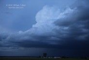
This chase day began in Portales, NM. Our fate was sealed the previous day with regard to chasing the northern Plains. Given the short tour… [Read More]
June 15, 2010 Tatum, NM LP Supercell

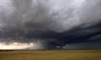
This was Day 2 of the short 4-day “mini-tour” out of OKC, and our group was in Lubbock. SPC showed a slight risk for severe… [Read More]
June 14, 2010 Tahoka, TX severe storms
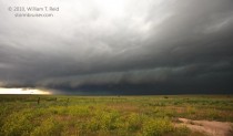
We targeted the southern Texas Panhandle this chase day, as a front or outflow boundary was sagging south of Lubbock. Upper and mid-level winds were… [Read More]
June 13, 2010 NE TX PH outflowish junk
A good chase day for many, but our group was unable to reach the target area in time. This was the “arrival day” in Oklahoma… [Read More]
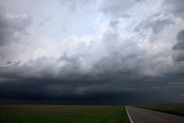
June 11, 2010 Limon, CO Supercell
A nearly stationary supercell, replete with a handful of highly visible and fairly long-lived tornadoes, developed just a couple of counties away from our starting… [Read More]
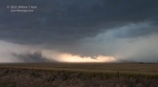
June 10, 2010 Last Chance, CO tornadic supercell

A very rewarding chase was had in northeastern Colorado, courtesy of a magnificent supercell that tracked east-northeastward right over Last Chance and through Washington County…. [Read More]
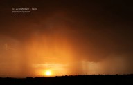
June 9, 2010 Scottsbluff cumulonimbus
We scooted north on I-25 from Colorado Springs to target something on or around the Cheyenne Ridge. Lunch was in Fort Collins, and, to my… [Read More]
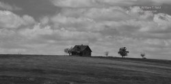
June 8, 2010 Colorado front range
We began this day in Burlington, and targeted the I-25 corridor from about Pueblo to Raton. Moisture appeared better near the Raton Mesa, but flow… [Read More]
June 7, 2010 Eastern Colorado Top 500 sunset
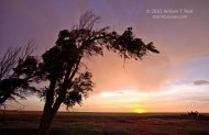
Our new tour group (T6) hit the road out of OKC and headed to the High Plains of extreme eastern Colorado via I-35 and I-70. … [Read More]
June 1, 2010 Palo Duro, TX Lightning
I played with some weak storms in the TX Panhandle this evening, as I need to be back in OKC tomorrow. We reached the edge… [Read More]
May 31, 2010 Campo, CO tornado Part 2 of 2

video of Campo Tornado on youtube The Campo tornado chase posts are in two parts on Stormbruiser. Part One covers the preliminaries from about… [Read More]
May 31, 2010 Campo, CO tornadoes Part 1 of 2

Memorial Day 2010 was a big day for chasers in Baca County, CO. A supercell went up early in the afternoon, spit out a couple… [Read More]
May 30, 2010 Billings, OK Messy storms
Kirstie and I had a few days to chase together in my X-terra between the end of Tour 4 and my flight back to California. … [Read More]
May 26, 2010 DIA supercell, CO
Our day began in Goodland. My target area was the Cheyenne Ridge area around Cheyenne, but it was a shaky target! I posted the following… [Read More]
May 25, 2010 west-central KS tornadic supercells
This was a somewhat odd chase day. We began in Murdo, SD, and had a long drive to make in order to get to the… [Read More]