
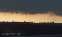
A great tornado chase today! Our chase tour (with Brian Morganti and Chris Gullikson) started out of OKC two days prior, and we were quite… [Read More]
May 23, 2010 Goodland, KS tornadoes
We began the day in Dodge City, with a target of somewhere around Atwood, KS, in the northwest part of the state. A warm front… [Read More]
May 22, 2010 nowhere near Bowdle, SD
A HUGE day! Severe weather parameters proclaimed “all storm chasers shall place themselves in front the South Dakota surface low!” It was an easy forecast. … [Read More]
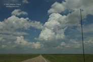
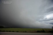
May 20, 2010 Hill County, TX marginal severe
On this, the final full chase day for Tour 3, we had a chance for severe weather down in the DFW region, along a boundary… [Read More]
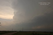
May 19, 2010 Blaine and Kingfisher counties, OK, tornadic supercell
High risk! High risk in OK! High risk in OK in May! High risk in OK in May near OKC! High risk in OK in… [Read More]
May 18, 2010 Moore County, TX tornadic supercell

From Portales, NM, we headed north towards the western OK PH. Conditions appeared favorable for supercells here, and as it turned out, we overshot to… [Read More]
May 17, 2010 Artesia, NM severe storms
This day began in Odessa, TX, and we motored northwest into NM for some fun. Near Artesia we watched a couple of strong storm towers… [Read More]
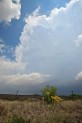
May 15 and 16, 2010 Marathon, TX convection
On both the 15th and 16th we were in Fort Stockton for lunch, and from there we headed southwest towards Alpine on U.S. 67. We… [Read More]
May 14, 2010 Permian Basin TX supercells and lightning
Today we woke up pretty much where we needed to be — in Midland, TX. A boundary was oriented WSW-ENE a little north of I-20… [Read More]
May 13, 2010 Reposition to SW TX
This morning we had the new alternator installed onto the van, and so we got a somewhat late start. Fortunately, the severe threat was fairly… [Read More]
May 12, 2010 Carter to Clinton, OK supercell

This day featured much consternation and a pretty good western OK supercell. The consternation was due to a mechanical breakdown on one of the tour… [Read More]
May 11, 2010 Chase Update
I suppose it’s time for an update from Plains Central. When we last left you, we were at the beginning of my first chase tour… [Read More]
May 11, 2010 Woodward County, OK supercell
The atmosphere over the southern Plains was much more relaxed compared to yesterday! A strong cap and weak boundaries were above western OK. With decent… [Read More]
May 10, 2010 Red Rock, OK tornadic supercell
Today’s atmospheric setup showed huge potential for nasty tornadic supercells in OK, and the potential was realized during the afternoon and evening! A tornado outbreak… [Read More]
May 3-8, 2010 Last half of Tour 2
Unfortunately, the last half of this tour was a little short on good storms. On May 3rd, we viewed a dud cumulus field from a… [Read More]