

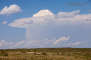
Start: Wray, CO Lunch: Brush (Wendy’s and Subway) End: McCook, NE 427 miles SPC Day One (20z) SPC Mesoscale Discussion 833 SPC Mesoscale Discussion… [Read More]
December 14, 2018 Dim Comet and No Meteors from San Nicolas Island
There was a comet to look for this evening — Comet Wirtanen. It was about as bright and close to the Earth as it… [Read More]
October 7, 2018 Vandenberg SpaceX Rocket Launch from San Nicolas Island

This evening I was ready with my tripod and camera on a nearby hilltop here on San Nicolas Island. A SpaceX rocket launch from… [Read More]
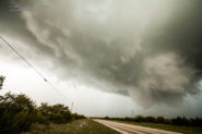
June 18, 2018 Weld County, Colorado, supercells
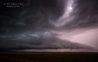
I have some catching up to do before getting to June 18. On June 12, Tour 6 and the Mini A group “chased” the… [Read More]
March 1, 2018 Trona Moonrise and Lenticulars
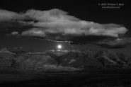
This afternoon looked good for a 3-4 hour drive into the northern Mojave Desert, as some mountain wave clouds (lenticulars) appeared likely. The lenticulars… [Read More]
January 18, 2018 Panamint Landscape and Moonset
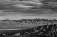
This entry features some zoom shots during the late afternoon and evening of January 18th on the Panamint Valley’s northern playa, culminating with… [Read More]
September 10, 2017 San Nicolas Island Electrical Display

I have had sporadic luck through the years photographing lightning locally in the Los Angeles area. The best displays are typically at night, from… [Read More]
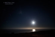
September 2, 2017 Moonlight on Malibu

Southern California was enduring an impressive heat wave on this Labor Day weekend. At my place in Westlake Village, the high temperature reached 108F… [Read More]
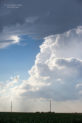
July 2, 2017 Western Nebraska Severe Storms
You can always count on western Nebraska to come through in early July! Start: Denver AP Lunch: Fort Morgan End: Cozad, Nebraska 453 miles SPC… [Read More]
June 21, 2017 South-central Nebraska Supercells
Begin: Phillipsburg, KS Lunch: Kearney (The Egg and I) End: Norton, KS 296 miles SPC Day One 1630Z Convective Outlook SPC Mesoscale Discussion… [Read More]
June 14, 2017 Evening Supercell east of Wichita, KS

Start: York, NE Lunch: Beatrice, NE/Runza End: Wichita, KS 424 miles 1630Z SPC convective outlook SPC Mesoscale Discussion 1032 SPC Storm Reports … [Read More]
May 2, 2017 Booker, TX nighttime supercell
Start: OKC End: OKC 430 miles I made my way to OKC on Tuesday, May 2, and with Bob C. and Bill S.,… [Read More]
August 11, 2016 Perseids from Chuchupate

The Perseid meteor shower was likely to be a lot better this year — so said the folks who presumably know these things. The… [Read More]
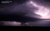
June 16, 2016 Flasher, ND supercell
Flasher is a tiny community southwest of Bismarck and Mandan, in south-central North Dakota. We were treated to a very pretty storm here on… [Read More]
April 20, 2016 Mertzon, TX hailer
Chase start–Fort Stockton, TX; lunch–Fort Stockton (The Steak House); end–Lubbock, TX; 489 miles Fresh off of our successful tornado catch the day before, we… [Read More]