
After a long couple of chase days, I began this one in Oklahoma City. It was time to head to Denver for the next three… [Read More]
May 25, 2009 Northern TX Panhandle
Chase prospects for May 25th looked a little better than previous days, down in the TX Panhandle. We began the day in Fort Morgan, and… [Read More]
May 20, 2009 Northwest Nebraska storms
This chase day began in Rapid City, and we targeted the northwest Nebraska Panhandle. A storm went up on schedule and looked somewhat impressive, near… [Read More]
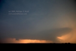
May 19, 2009 Alzada, MT Virga BOMB!
Whoohoo! Our chase team intercepted a very high-based storm cell in extreme southeastern Montana, and photographed precipitation which may or may not have reached the… [Read More]
May 12, 2009 SE TX PH severe cells

May 12 wound up rather disappointing, though we wound up on strong storm cells from about Memphis to Childress to Quanah. Prior to initiation, we… [Read More]
May 8, 2009 Brown County, TX, supercell
Friday, May 8, wound up to be a very entertaining chase day, as our group found itself just east of a beast of a supercell… [Read More]
May 7, 2009 Cameron, MO supercell

Our group departed Edmond, OK, and I was thinking/hoping for thunderstorm development by late afternoon in eastern Kansas. Instability was moderate, shear was excellent, and… [Read More]
May 1, 2009 Big Country Supercells
On May 1 we targeted northwest TX, and dropped south to Vernon for lunch. Storm towers went up kind of early to our southwest, in… [Read More]
April 25, 2009 Cordell, OK marginal severe
This day began on the NM/AZ border along I-40, at a rest area where a train passes every 15 minutes and blasts its horn for… [Read More]
June 26, 2008 Thedford, NE LP Supercell
After lunch in Kadoka, we moseyed east on I-90 to Murdo, on U.S. 83. Unfortunately, it looked like we were exactly between two areas of… [Read More]
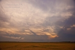
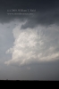
June 24, 2008 Isabel, SD Cumulonimbus and mammatus sunset
A long and somewhat disappointing day culminates in a spectacular sunset on the back side of severe storms in Corson County, SD. We started out… [Read More]
June 18, 2008 SW and SC Nebraska severe cells

A strong cell became established somewhat early in the afternoon south of Ogallala, and dove SE towards McCook. We blasted east from Wray and plunged… [Read More]
June 15, 2008 Booker, TX Supercell
After lunch at a lovely Mexican Restaurant in Pampa, we drifted north towards the extreme northeastern corner of the Texas Panhandle. We sat under a… [Read More]
June 14, 2008 SE TX PH CB…
…which, as everyone knows, stands for “southeast Texas Panhandle cumulonimbus”. Our target area on this day was along I-40 between Shamrock and Amarillo. And, the… [Read More]
June 13, 2008 SW OK Storms

A boundary ran roughly SW-NE through southwest Oklahoma, and we watched towers struggle against the strong cap for much of the afternoon near Chickasha. A… [Read More]