
This was a long day, as I began in Storm Lake, IA, and had to meet Brian and the Tour 5 group in Lincoln, NE…. [Read More]
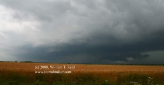
June 11, 2008 Ashton, IA Supercell
This was the make-or-break day for the short private tour. The tornado potential appeared to be pretty good in northwest Iowa, and in adjacent parts… [Read More]
June 7, 2008 Blue Hill, KS Tornadic Supercell
ONLINE VIDEO! After five days back home in Los Angeles, I flew back to DFW on June 5th. The 6th was spent driving from… [Read More]
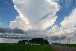
May 29, 2008 Kearney, NE Tornadic Supercell
By noon-ish we were heading east along I-80 in central Nebraska, near Kearney. The outlook for significant tornadoes on this day was very good… [Read More]
May 25, 2008 Central Kansas Storms
The big play this day was in Iowa, where the Parkersburg monster tornado formed. We began the day in Salina and played central Kansas. We… [Read More]
May 24, 2008 Hennessey, OK Tornadic Supercell
A lone, isolated supercell was a prolific tornado producer as it moved slowly through Kingfisher County and Garfield County in Oklahoma on May 24, 2008. … [Read More]
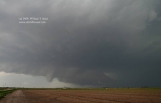
May 23, 2008 Clark County, KS Tornadic supercell
The timing of the switch from Tour 2 to Tour 3 was not good. We had put up with a lousy pattern for five or… [Read More]
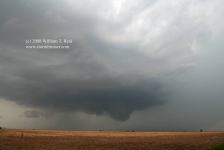
May 22, 2008 Grainfield, KS Cyclic Tornadic Supercell
Gad, I had not seen a good-sized and photogenic tornado for far too long. The last one up until 5-22-08 was on 5-22-07, near Wakeeney,… [Read More]
May 15, 2008 Eagle Pass, TX Supercell
At our morning briefing in Fredericksburg, we targeted the Rio Grande River area somewhere between about Del Rio and Eagle Pass. Parameters looked good for… [Read More]
May 14, 2008 Texas Big Country Supercells
Yet another big day with somewhat high hopes for tornadoes! My forecast target spot was a little west of San Angelo, TX, and that worked… [Read More]
May 9, 2008 Grant, NE supercell

Great Scott……I had a tough decision to make on this morning in Dodge City. Should I play today or tomorrow? Today—a good chance of a… [Read More]
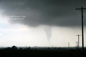
May 8, 2008 Jetmore, KS supercell
Also known by precious few as the famous Shallow Water/Jetmore/Kinsley supercell, this storm began its life by spitting out landspout-type tornadoes in Wichita County, KS,… [Read More]
May 5, 2008 Garden City, KS Supercell

This was Day 5 for Tour 1, with 11 guests and my drivers Jennifer Dunn and Bob (“I just opened a new tab”) Conzemius. We… [Read More]
May 1, 2008 Hail Fredonia

And “Tornado Fredonia”, too, but we could not see it, despite looking at the supercell on its southeast side as it came up to Fredonia,… [Read More]
April 26, 2008 San Angelo, TX supercell
It is chase season again on the Great Plains! I abandoned Los Angeles on Friday, April 25th, and stayed in Las Cruces, NM, on Friday… [Read More]