
This entry written in February, 2026 I was contacted by Dr. Roy Spencer (of the University of Alabama in Huntsville) in November, 2024, regarding my… [Read More]
Highest Temperature Reports in Death Valley (and California)
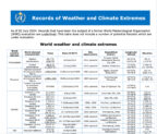
This write-up was uploaded to my web site on October 9, 2025 (and was updated on November 14, 2025, in the Stovepipe Wells section). A… [Read More]
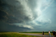
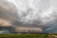
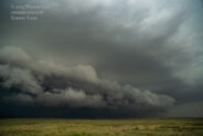
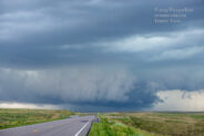
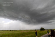
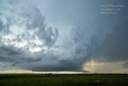
September 18, 2025 Boron, CA Supercell Chase
On this day I managed to chase, observe and photograph perhaps the best California supercell storms that I have yet to witness! And, I was… [Read More]
Badwater Monthly Data NASA station JJA 1998-2019
Photo above: The Badwater weather instrumentation in July, 2024. This is where McKay’s NASA station at Badwater was located from 1998 to 2019. The NWS… [Read More]
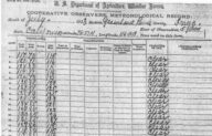
Death Valley Long Term Climate Data
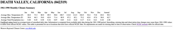
I find myself often digging into old climatological publications for Death Valley weather and climate records. This entry is designed to help stick much of… [Read More]
June 27, 2025 Ideal, South Dakota Supercell
Start: Chadron/lunch: Antelope Cafe in Gordon, NE/End: Valentine, NE/415 miles Storm Reports SPC Day One 20Z Mesoscale Discussions. 2:45 p.m. CDT. 5:07 p.m. CDT. 6:47… [Read More]
June 24, 2025 Severe Bennett to Merino, CO
Start: Lamar, CO/lunch: maybe near Greeley??/End: Julesburg/476 miles Storm Reports SPC Day One 20Z Mesoscale Discussions. 1:35 p.m. CDT. 5:05 p.m. CDT. We got out… [Read More]
June 23, 2025 Baca County Supercell
Start: Sidney, NE/lunch: Arbys and Subway in Limon/End: Lamar/568 miles Storm Reports SPC Day One 20Z Mesoscale Discussions. 4:45 p.m. CDT (no SPC MD for… [Read More]
June 22, 2025 Bridgeport, NE, Windbag
Start: Denver, CO/lunch: Heritage Cafe in Kimball/End: Sidney, NE/391 miles Storm Reports SPC Day One 20Z Mesoscale Discussions. 1:50 p.m. CDT. 5:26 p.m. CDT. 7:55… [Read More]
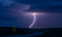
June 19, 2025 My First Sprite Photo!
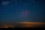
Note: scroll down for the boring chases on June 19 and June 20. On the evening of June 19 I went out into the hinterland… [Read More]
June 18, 2025 Red River Storms
Start: Canadian, TX/lunch: Sayre BBQ (First Response Cafe)/end: Shamrock/452 miles Storm Reports SPC Day One 20Z Mesoscale Discussions. 2:39 p.m. CDT. 8:39 p.m. CDT The… [Read More]
June 17, 2025 Booker to Glazier Severe
Start: Oberlin, KS/lunch: quick grab-and-go at Casey’s in Hill City/End: Canadian, TX/441 miles Storm Reports SPC Day One 20Z Mesoscale Discussions. 1:27 p.m. CDT. 5:16… [Read More]
June 16, 2025 The Wellfleet/Dickens, Nebraska Tornado (Part One, the account)
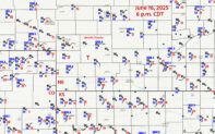
I have made two Stormbruiser web entries for this chase day. This page, Part One, contains the chase account and iPhone images and the video… [Read More]
June 16, 2025 The Wellfleet/Dickens, Nebraska Tornado (Part Two, the images)
This Part Two web entry contains a large selection of images off of the Canon cameras for the Wellfleet/Dickens tornado event. The chase account, including… [Read More]
June 15, 2025 Merriman, Nebraska, LP Supercell
Start: Holyoke, CO/lunch: Grandma Jo’s in Sidney, NE/End: Valentine, NE/409 miles Storm Reports SPC Day One 20Z Mesoscale Discussions 2:13 p.m. CDT (Montana) 3:49 p.m…. [Read More]
- 1
- 2
- 3
- …
- 85
- Next Page »