This chase day had it all: supercells, a tornado, unreal sunset colors, and old, abandoned vehicles in a ghost town! What more could a chase tour want? Oh, yes — lunch at the Big Texan! Yum!
Setup: This was the final chase day for Tour 4, with my buddies Rook and Steve P. as my drivers for Tempest. Our tour had had a wonderful tornado day near Canadian, TX, two days earlier, and we would try our luck one more time on the Southern Plains on this last Friday in May. We observed some interesting severe storms near Dalhart, TX, on the previous afternoon, and began this day in Vega. SPC showed a large slight risk area covering much of West Texas and the eastern-most part of New Mexico in their 1630Z outlook. A two-percent tornado risk area covered the TX/NM border area from about Nara Visa to Andrews.
The 1630Z Day One discussion by SPC:
...SYNOPSIS...

   THE PRIMARY BELT OF POLAR WESTERLIES WILL REMAIN CONFINED TO CANADA
   IN ASSOCIATION WITH A VIGOROUS SHORT-WAVE TROUGH WHICH WILL
   TRANSLATE SEWD FROM MANITOBA INTO ONTARIO.  THIS SYSTEM WILL BE
   LOOSELY PHASED WITH A LOWER-LATITUDE SHORT-WAVE TROUGH WHICH WILL
   TRACK FROM WY/CO INTO THE MID MO VALLEY AND UPPER MIDWEST.
   ELSEWHERE...A VORTICITY MAXIMUM --LARGELY OF CONVECTIVE ORIGIN--
   WILL PROGRESS FROM THE SRN PLAINS INTO OZARKS AND LOWER MS VALLEY.

   AT THE SURFACE...A COLD FRONT ASSOCIATED WITH THE CNTRL CANADA
   UPPER-AIR SYSTEM WILL ADVANCE SEWD THROUGH THE UPPER GREAT LAKES AND
   MID/LOWER MO VALLEY WITH THE WRN EXTENSION OF THE FRONT REACHING THE
   SRN HIGH PLAINS LATE TONIGHT INTO EARLY SATURDAY.

   ...SRN HIGH PLAINS THIS AFTERNOON INTO TONIGHT...

   MORNING WATER VAPOR IMAGERY IS SUGGESTIVE OF A WEAK MID-LEVEL
   IMPULSE ALONG THE AZ-NM BORDER WHICH SHOULD CONTINUE ESEWD TODAY
   WITHIN THE SRN PERIPHERY OF THE MORE PROMINENT WY/CO SHORT-WAVE
   TROUGH MENTIONED ABOVE.  FORCING FOR ASCENT ASSOCIATED WITH THIS
   FEATURE COUPLED WITH AN INCREASING LOW-LEVEL UPSLOPE WIND COMPONENT
   WILL FOSTER THE DEVELOPMENT OF TSTMS THIS AFTERNOON FROM THE RATON
   MESA SWD ACROSS PARTS OF ERN NM WITH ACTIVITY MOVING/DEVELOPING
   ESEWD INTO WRN TX LATE THIS AFTERNOON INTO EVENING.

   12Z UPPER-AIR DATA INDICATE THAT LOW-LEVEL MOISTURE QUALITY IS
   POORER THAN PAST DAYS.  HOWEVER...ABUNDANT SUNSHINE IN CONCERT WITH
   RELATIVELY COOL MID-LEVEL TEMPERATURES /I.E. -11 TO -13 C AT 500 MB/
   SHOULD SUPPORT MODERATE AFTERNOON INSTABILITY WITH MLCAPE OF
   1000-2000+ J/KG.  THIS INSTABILITY WILL ALIGN WITH A CORRIDOR OF
   MODEST /30-35 KT/ DEEP-LAYER SHEAR WHICH WILL PROMOTE MULTICELL AND
   SOME SUPERCELL STRUCTURES WITH THE INITIAL HAZARD BEING SEVERE HAIL.
   BY THIS EVENING....STORMS MAY EVOLVE INTO A FORWARD-PROPAGATING TSTM
   COMPLEX WITH THE MAIN SEVERE WEATHER RISK TRANSITIONING TO DAMAGING
   OUTFLOW WINDS.
Shear and instability looked decent for supercells, but certainly not great. The flow at 500 mb was marginal, just 25 knots or thereabouts from the W to WNW. At the surface was generally weak upslope flow with dew points in the low-to-mid 50s. At 18Z, winds were light and from the northeast along the NM/TX border, but these were expected to strengthen and be more easterly towards sunset, especially south of I-40. Forecast models indicated afternoon storm development on the high terrain of eastern NM and moving towards the TX border into the evening hours. As SPC noted, sunshine was plentiful over the outlooked area. Storms would start out quite high-based. As usual, the key on this day would be to find the right storm at the right time. The models did not have a “go here” signal. I targeted the area around Tucumcari for starters, but in the back of my mind I figured that the best that this day might have to offer would likely be towards evening…well after initiation…closer to the NM/TX border versus well west of the state border. I did NOT want to get suckered too far west towards marginal junk! I needed to stay a little east, see how the early stuff evolved, and keep fast north-south options close by.
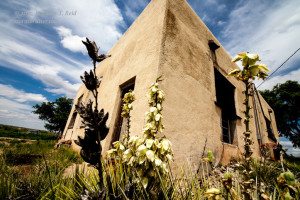
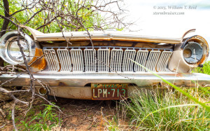
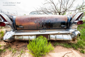
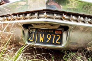
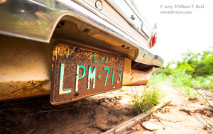
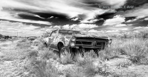
The Chase: After the morning weather briefing in Vega, I elected to head back east into Amarillo for a stop at Cadillac Ranch for the gang and for lunch at the Big Texan. The target area was no more than a couple of hours to the west of Amarillo, so why not?! After lunch we made our way west on I-40 to the NM/TX border. Some new convection was brewing in the usual spots in New Mexico — on the high terrain around Taos and Las Vegas and vicinity. I ignored these storms and dragged the group into Endee, NM, to kill time. We spent close to an hour in the mid-afternoon sunshine perusing the abandoned shacks and automobiles. Endee is (was?) along Route 66, and was unceremoniously bypassed by Interstate 40. It had a motel and a filling station in its heyday! Now it is a graveyard for machines which seemingly were unable to complete their assigned journey.
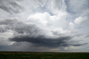
The skies above Endee featured plenty of cirrus, and by the time we turned our attention back to the weather, there were some strong storms west and northwest of Tucumcari. It was between 3 and 4 p.m. MDT, I figure: still a little on the early side, but time to find a storm. A mesoscale discussion had been recently issued by SPC. It covered practically all of northeastern NM as far south as Portales and Dora, and the westernmost counties of the Texas Panhandle from Dalhart to Levelland.
MESOSCALE DISCUSSION 0835
   NWS STORM PREDICTION CENTER NORMAN OK
   0227 PM CDT FRI MAY 29 2015

   AREAS AFFECTED...NE NM...SE CO...WRN TX PANHANDLE...WRN OK
   PANHANDLE...

   CONCERNING...SEVERE POTENTIAL...WATCH POSSIBLE

   VALID 291927Z - 292100Z

   PROBABILITY OF WATCH ISSUANCE...60 PERCENT

   SUMMARY...A SEVERE THREAT IS EXPECTED TO DEVELOP THIS AFTERNOON
   ACROSS NE NM AS CELLS INCREASE IN COVERAGE AND SPREAD EWD INTO THE
   TX AND OK PANHANDLES. HAIL AND ISOLATED DAMAGING WIND GUSTS WILL BE
   THE PRIMARY THREATS ALTHOUGH A TORNADO CAN NOT BE RULED OUT. WW
   ISSUANCE MAY BE NEEDED ACROSS THE REGION.

   DISCUSSION...THE LATEST SFC ANALYSIS SHOWS A SFC TROUGH FROM THE
   VICINITY OF EL PASO EXTENDING NWD INTO CNTRL AND NRN NM. SFC
   DEWPOINTS TO THE EAST OF THE SFC TROUGH ARE GENERALLY IN THE LOWER
   50S F AND AN AXIS OF LOW-LEVEL CONVERGENCE IS EVIDENT TO THE EAST OF
   THE SANGRE DE CRISTO MTNS NEAR INTERSTATE-25. THUNDERSTORMS ARE
   DEVELOPING ALONG THIS CORRIDOR ATTM. ACCORDING TO SHORT-TERM MODEL
   FORECASTS...THIS CONVECTION WILL CONTINUE TO EXPAND IN COVERAGE
   MOVING EWD INTO THE LOWER ELEVATIONS OF NERN NM THIS AFTERNOON. AN
   AXIS OF INSTABILITY IS ANALYZED FROM WEST TX EXTENDING NWWD INTO NE
   NM WHERE MLCAPE IS ESTIMATED BETWEEN 500 AND 1000 J/KG. IN
   ADDITION...MODERATE DEEP-LAYER SHEAR APPEARS TO BE IN PLACE ACROSS
   NE NM. THIS IS DUE TO DIRECTIONAL SHEAR AT LOW-LEVELS AND SOME SPEED
   SHEAR ALOFT WITH 35 TO 40 KT OF WLY FLOW AT 4 KM ON THE AMA WSR-88D
   VWP. THIS COMBINED WITH RELATIVELY STEEP LAPSE RATES SHOULD BE
   FAVORABLE FOR A SEVERE THREAT. IF A COLD POOL CAN DEVELOP AS THE
   HRRR SUGGESTS...THEN A WIND DAMAGE THREAT WOULD BE POSSIBLE WITH THE
   BETTER ORGANIZED LINE SEGMENTS. HAIL MAY ALSO OCCUR WITH THE
   STRONGER CORES.

   ..BROYLES/MEAD.. 05/29/2015
This update noted better mid-level flow than anticipated, which was welcome! And, the big arrow pointed right to Tucumcari, where a cumulus field was bubbling and where we were headed. Life was good! A severe thunderstorm watch was out by 3 p.m. MDT.
SPC Severe Thunderstorm Watch 240
We latched onto a growing cumulonimbus cloud that was just northeast of Tucumcari. It was rather small and unremarkable, but it held our attention. Meanwhile, a severe-warned storm was some 30-40 miles to our west-northwest. Did I want to scamper towards it? We had a decent view of that, and some curious scud was gathering beneath its base. Radar showed rotation, and a chaser or two were on it. Nope. Not gonna do it. Too many times have I been suckered west on the High Plains, only to miss better stuff later in the better moisture farther east. I needed to be patient. I needed to stick relatively close to the NM/TX border, especially in this region with the so-so road network. Here is a look at the Tucumcari storm…
…not exactly a jaw-dropper, is it?! The bigger and badder storm to our WNW continued to look good, and it was moving southeastward. It had a rotating updraft and was propagating to the right of the mid-level flow. Also, new storms were erupting to our southwest by perhaps 30 – 40 miles. These became heavy rather quickly. I decided that it would be very prudent to keep all of this activity in play, and that meant getting ourselves east of those cells that were to our southwest. I could still keep an eye on the I-40-area storms in case those really started to crank. We drove east to San Jon and blasted south towards Grady, NM. During this time, the storm to our southwest had evolved into a big HP supercell that was tracking to the southeast! I no longer cared about the junk to the north. The supercell was near Quay, NM, and I had the option at Grady to head towards it and try to beat it south on the road to Melrose. But, that seemed too risky and too close of a call, so I played it safe, and headed east out of Grady to the next south option (209 to Broadview and Clovis).
It was taking so long to get into position on this big and nasty-looking supercell, now to our west-southwest! It was moving right along at about 25 mph to the southeast, and these wide-open but slow (55 mph speed limit) New Mexico roads were killing me! And, as we entered Clovis, we had to deal with Friday rush-hour traffic and plenty of traffic signals —UGH! Onward we pressed, as the radar returns showed large hail and strong rotation in the vicinity of Melrose. Our south route, U.S. 70, angled off to the southwest and would help put us in good position in front of the supercell. And it was at this point that this day’s patience and conservative decision-making paid off. A new, strong updraft was exploding in front of the HP supercell, on the southwest side of Portales!
The Portales storm organized quickly and was a relatively easy intercept. Its presence greatly diminished the flow of warm and moist air at the surface into the Melrose supercell. The Melrose storm sputtered, and we were right in front of a big and nasty (though somewhat high-based) supercell. Whoohoo!
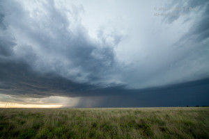
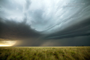
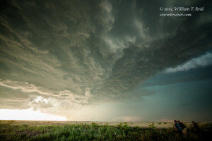
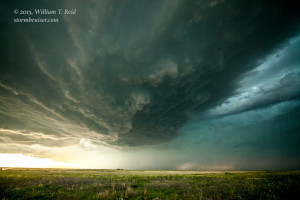
This storm had a nice, sculpted look and a fine inflow band. The views above are towards the west and were taken along Road 206 between Portales and Dora, in Roosevelt County. The storm continued to the southeast at 20-25 mph and chased us south towards Dora. We stopped again as the storm base loomed just to our west.
This supercell was very well-organized and spinning hard! Since the storm base was rather high, I was not expecting a tornado chance, at least in the immediate future. The hail-filled core was only a mile or two to our north, and we continued south of Dora a bit to stay out of it. I was interested in getting a ways south and east for a good look at the storm structure before sunset. Road 458 out of Pep, NM, was a little too close to the storm core for this plan, so we kept on going south on 206. But, now there was another potential problem. A strong storm was just south and southwest of my next east option, Road 262, at tiny Milnesand. Its hail core was heading up towards Milnesand! There wasn’t much to hide under out here. We were VERY vulnerable, with a giant hail-filled supercell to our north and northwest, and a severe-warned storm encroaching to our south! I thought for sure that I was going to wind up at the glass-replacement place on Saturday.
I went into vehicle-survival mode. I directed Steve and Rook southward to Milnesand, and briefly forgot about any structure back to our west and northwest. Fortunately, we were able to head east on 262 prior to any hail, and we stopped after driving east a few miles. It was raining lightly here, out of the anvil, but the sunset light was nice and the hail threat seemed minimal for the moment. This is a look to the south from 262, towards the storm that was squeezing us and causing me consternation!
But, it was raining! I needed to lose this rain so I could set up in a dry spot to shoot storm structure! The only way that this was going to happen was to blast east. East we went, but just for a couple of miles. We were perhaps five miles east of Milnesand, and the light on the storm base behind us was just TOO GOOD to drive away from! Or, if you prefer, it was TOO GOOD from which to drive away! Stop!
And it is a good thing that we stopped. We turned right up a dirt road which put us up on a little high point, with a great view of the stormy golden-and-black scene to the west-southwest.
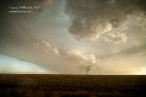
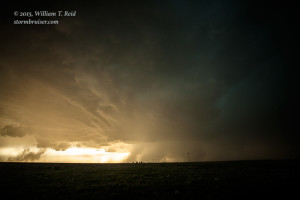
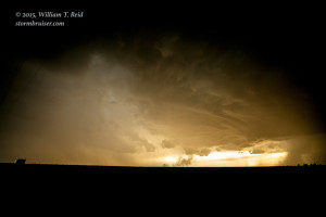
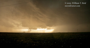
In these wide-angle (15mm) images, the power lines lead to the west down Road 262. A roundish and rain-free updraft base is quite prominent to the west, with a blocky wall cloud. A plume of smoke near the surface is being sucked up into the left side (southeast side) of the updraft base; the smoke presumably due to a recent lightning strike and resulting brushfire (as seen in the shot from the previous location, above). On the north side of the rain-free storm base is the rain-and-hail region with the “Portales/Dora” supercell. Apparent is a handful of very heavy precipitation cores — see image 1523. These cores are north of Milnesand’s latitude. A “lighter” area of precipitation is visible to the left of the rain-free base. This precipitation is courtesy of the storm that is moving eastward on the south side of Milnesand. Relatively light and narrow swaths of precipitation are discernible between our location and the rotating updraft base. The two storms are on a collision course.
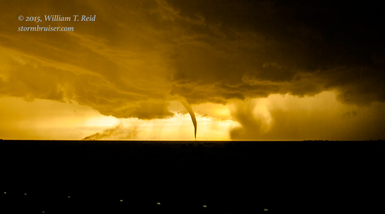
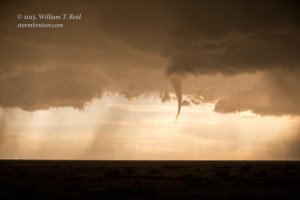
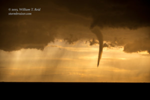
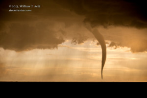
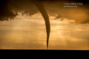
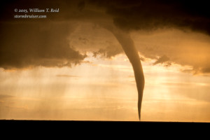
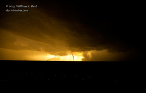
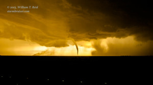
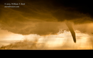
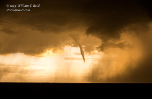
Why do I mention all of these stormy ingredients? Because they effectively conspired to spawn a beautiful tornado with the Portales-Dora supercell! If there had been no storm south of the Milnesand area, if there had been no rain-cooled outflow from the south to bump up against the rotating updraft near Milnesand, then I suspect that there would have been no tornado. The great sunset light continued to our west and west-southwest, and, much to our disbelief, the slender funnel cloud materialized and within a couple of minutes was smack down on the ground beneath the rotating updraft base!
I was juggling two cameras, and pointed the one with the wide-angle lens towards the tornado.
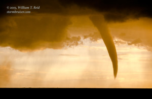
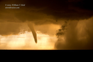
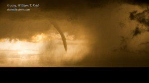
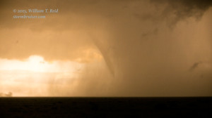
These are very wide, 15mm shots. The second one is cropped some. I was nice and dry in my tour director seat in the van, shooting out the open window. The guests were outside in the light rain, but they did not mind too much. This was a fantastic exclamation point to the end of their chase tour! The tornado was going to stick around for another minute or so, it seemed, so I switched back to the long lens for some close-ups.
The tornado did not move much, but a microburst to its north surged southward and precipitation eventually obscured the tornado from our perspective. Though daylight still appeared plentiful behind the storm, these zoom shots were at ISO 400, f 4.5 and shutter speed 1/60 second, suggesting rather dim conditions. Not many chasers witnessed this tornado, but chaser Christian Cleary managed to wind up in the right place at the right time along 206, with this awesome view!
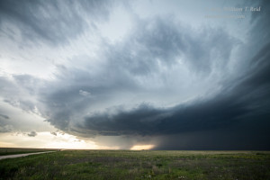
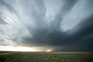
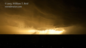
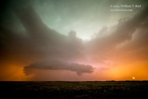
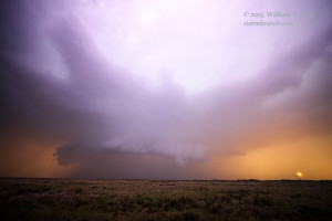
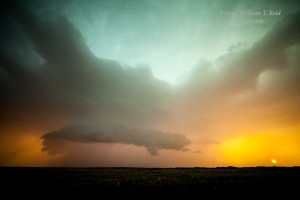
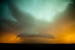
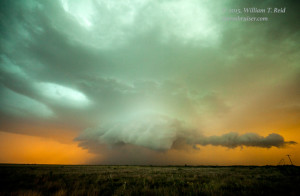
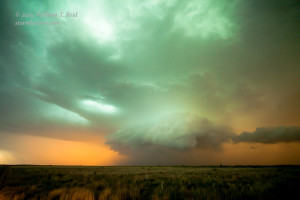
As the tornado disappeared behind the microburst, and as the shallow window of daylight closed to our west, it was again time to head east and maybe get out of this annoying rain. Again, we made it a few miles farther down the road, but we just had to stop again in the light rain as the light, the colors, and the storm structure back to the west was absolutely UNREAL!!
And, I know what you are saying —- “Come on, Bill, how can a storm look like that? Surely you are playing around a little too much in Photoshop!!” But, this is how it looked. Yes, I brightened the scene some and the contrast was bumped up a little, but the saturation levels did not have to be touched! The purples in image 2 of the 6 above is due to lightning in the updraft. That little ball on the right is the setting sun. Once more, these are wide-angle/15 mm/full frame/Canon 6D shots, all handheld, in the rain, ISO around 800, wide open at f2.8, and slow shutter speeds around 1/25 second. There were a few spectacular lightning bolts careening through this amazing and surreal wall of color. I tried but failed to catch one with the camera. Darn rain — it was too wet to set up and shoot properly with the tripod and cable release. This is the post-tornadic Portales/Dora supercell, spinning above Milnesand, New Mexico.
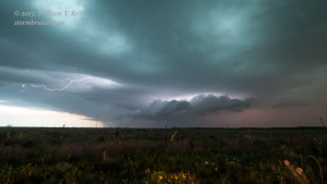
A little later we were inside Texas, I believe, with a little less rain and a little time to try for lightning. The storm was weakening a bit, though, as other storms developed nearby. This was the best I could manage.
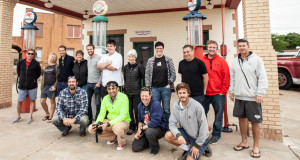
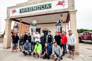
We had a rather prolific lightning display to enjoy to our northeast as we headed to Morton, TX. The convenience store there would serve as our Friday night dinner base, and then we were off to Amarillo and the motel for the night. A chase day like May 29 is why we keep coming back to the Great Plains in spring. Below is our group photo in Shamrock on the drive back to Oklahoma City on Saturday.




Leave a Reply
You must be logged in to post a comment.