
Severe weather prospects did not look too shabby on this chase day. In my morning briefing to the tour group in Fort Stockton,TX, I noted plenty of morning storm activity moving eastward through the Texas Panhandle area. The storms were expected to clear West Texas by early afternoon, and we would be looking for sunshine and redevelopment of storms along a surface outflow boundary during the afternoon and evening. SPC had a good handle on the situation in their 13Z outlook, with a slight risk and 5 percent tornado area centered around Snyder, TX.
SPC 1300Z Day One discussion:
...SUMMARY...
   A FEW SEVERE THUNDERSTORMS ARE EXPECTED THIS AFTERNOON INTO THE
   EVENING ACROSS PORTIONS OF THE TEXAS SOUTH PLAINS AND NORTHWEST
   TEXAS.

   ...TX S PLAINS/NW TX THIS AFTERNOON/EVENING...
   A MIDLEVEL SHORTWAVE TROUGH OVER SW NM THIS MORNING WILL EJECT NEWD
   TO OK/KS BY EARLY WEDNESDAY.  THIS PRIMARY WAVE WILL BE PRECEDED BY
   MCV/S MOVING NEWD OVER THE ERN TX PANHANDLE AND TX S PLAINS.
   WIDESPREAD OVERNIGHT CONVECTION WITH THE MCV/S HAS AND WILL CONTINUE
   TO LIMIT THE NWD EXTENT OF THE RICHER LOW-LEVEL MOISTURE RETURN AND
   STRONGER SURFACE HEATING.  IT APPEARS THAT LOW-LEVEL RECOVERY WILL
   BE POSSIBLE THIS AFTERNOON INTO THE TX S PLAINS AND NW TX IN THE
   WAKE OF THE MORNING CONVECTION...AND IMMEDIATELY IN ADVANCE OF THE
   PRIMARY EJECTING TROUGH.  WIDESPREAD CONVECTION SINCE YESTERDAY HAS
   REDUCED MIDLEVEL LAPSE RATES...BUT AFTERNOON MLCAPE VALUES COULD
   STILL REACH 1500-2000 J/KG IN THE ABSENCE OF A STRONG CAP.

   LOW-LEVEL MASS RESPONSE TO THE EJECTING TROUGH WILL CONTRIBUTE TO
   INCREASING LOW-LEVEL SLY FLOW AND RESULTANT VERTICAL SHEAR
   ...ESPECIALLY THIS EVENING...SUCH THAT SUPERCELLS WILL BE POSSIBLE.
   THE MORE PROBABLE FOCUS FOR SUPERCELL DEVELOPMENT THIS
   AFTERNOON/EVENING WILL BE E OF THE DRYLINE ALONG ANY RESIDUAL
   OUTFLOW/DIFFERENTIAL HEATING BOUNDARIES ACROSS THE S PLAINS OR NW
   TX.  ISOLATED LARGE HAIL AND DAMAGING WINDS WILL BE POSSIBLE...ALONG
   WITH A COUPLE OF TORNADOES.

   ..THOMPSON/ROGERS.. 05/05/2015
My plan was to head north to Midland and maybe Lamesa, depending on where the outflow boundary was. We had a very leisurely lunch in Midland at a yummy BBQ joint, and I was thinking that there was no rush to get anywhere anytime soon. The updated (1630Z) Day One outlook from SPC sang the same tune for the most part, noting the location of the outflow boundary and the uncertainty regarding initiation and storm coverage.
1630Z Day One discussion from SPC:
...TX/OK...
   MORNING SURFACE ANALYSIS SHOWS A REMNANT OUTFLOW BOUNDARY FROM
   OVERNIGHT CONVECTION EXTENDING FROM NORTH OF MAF TO WEST OF CDS.
   CONSIDERABLE CLOUDS AND PRECIPITATION CONTINUE ALONG AND NORTH OF
   THIS BOUNDARY...BUT RECENT SATELLITE AND MODEL TRENDS SUGGEST THAT
   SLOW CLEARING WILL OVERSPREAD WEST TX THROUGH THE LATE MORNING AND
   EARLY AFTERNOON.  THE RESULT WILL BE A REGION OF MODERATE
   INSTABILITY AND INCREASINGLY FAVORABLE VERTICAL SHEAR PROFILES FOR
   SEVERE STORMS.  THE MAIN FORECAST PROBLEM IS INITIATION.

   WATER VAPOR SHOWS THE UPPER TROUGH OVER AZ SLOWLY DRIFTING
   EASTWARD...AND IT SEEMS PLAUSIBLE THAT THERE ARE SUBTLE FEATURES
   EMBEDDED IN THE CYCLONIC FLOW EXTENDING INTO WEST TX.  HOWEVER...THE
   LINGERING EFFECTS OF THE MORNING CONVECTIVE SYSTEM COUPLED WITH SOME
   CAPPING AND APPARENTLY WEAK LARGE SCALE FORCING RESULT IN CONCERN
   FOR STORM COVERAGE LATER TODAY.  PRESENT INDICATIONS ARE THAT AN
   ISOLATED STORM OR TWO WILL FORM IN THE CORRIDOR AHEAD OF THE DRYLINE
   FROM WEST OF LBB - NEAR MAF - NEAR SANDERSON.  FORECAST SOUNDINGS
   /ESPECIALLY ON THE NORTHERN END OF THIS CORRIDOR/ APPEAR
   CONDITIONALLY FAVORABLE FOR SUPERCELLS WITH ALL SEVERE
   THREATS...INCLUDING A TORNADO OR TWO.
..HART/BROYLES.. 05/05/2015
This chase day was not unlike many, many others in the annals of storm chasing. It was not a high-end day, for sure, but there was enough shear and instability to give us a chance for a tornadic supercell. Throw a “stationary outflow boundary in the afternoon sun of West Texas in early May” into the equation, and a chaser’s attention should increase manyfold.
Is was not until about 2 p.m. that we headed north out of Midland, heading north on 349 into the mostly empty flatlands between Andrews and Tarzan. At 2 p.m. the wind at Midland was from the southwest, with 79 over 56 (temperature over dew point), yet just up the road at Lamesa, the wind was from the southeast with 70 over 63. Very juicy air lurked just to the east at Big Spring and Sweetwater, where dew points were in the mid-60s. The skies were clearing nicely, and some new convection was already showing itself just to our east-northeast. Well, this certainly appeared to be in the right place, along the boundary. But I was concerned that it was too early for storms! Typically, when strong storms develop before 3 p.m., a chaser winds up with a lot of mediocre junk fairly quickly. With Chad’s help, we vectored eastbound from 349 on 176 towards Lenorah, and then east on 846. The updraft was looking good and was remaining discrete and isolated. It was easy to get south of the storm base, in the vicinity of Knott, in northwestern Howard County.

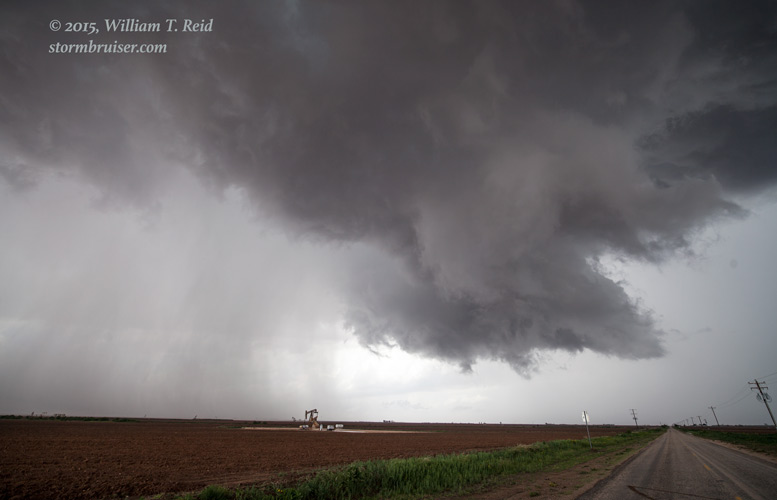
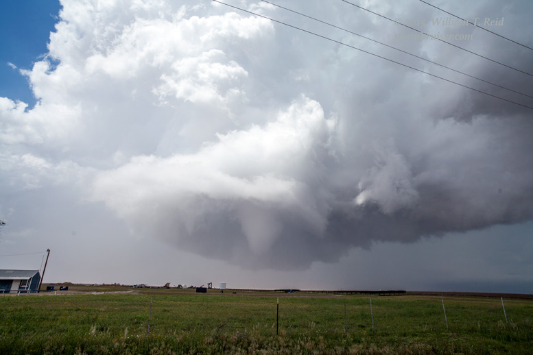
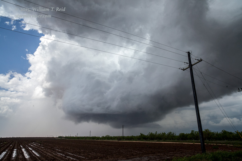
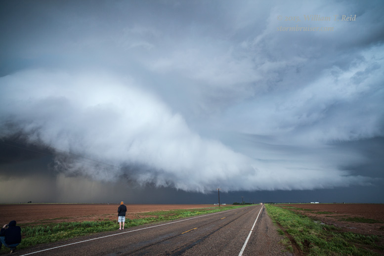
The images above were taken near Knott, and the view is to the north. A prominent “lowered” area organizes as a swath of precipitation through the updraft base diminishes. A tail cloud develops on the right side of the wall cloud in the last image, and the clear slot associated with the RFD can easily be detected as it “eats” into the storm base.
We were chased east down 846 to U.S. 87 (about 13 miles NNW of Big Spring) and stopped again.
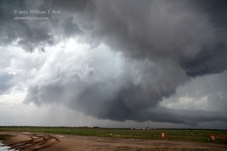

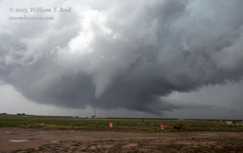

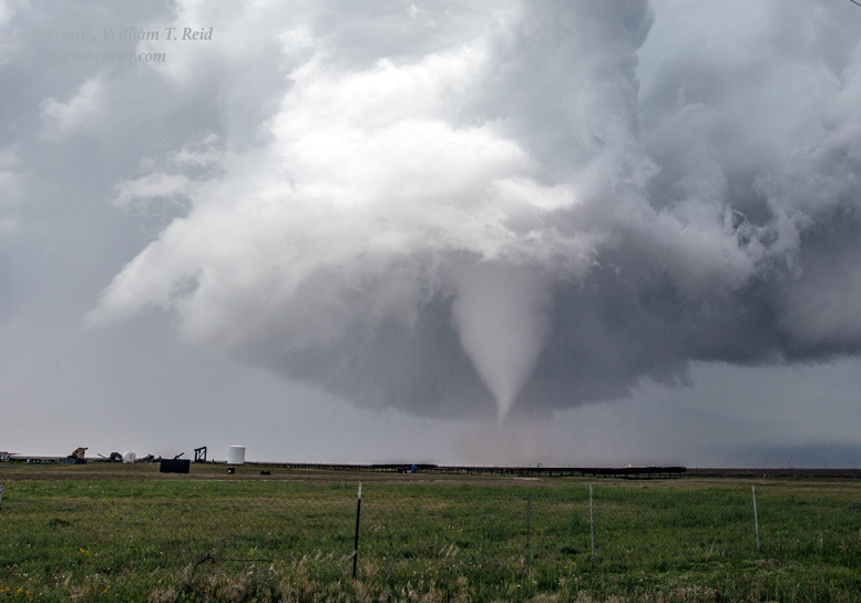
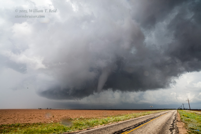
A funnel cloud was developing in the strongly rotating updraft base on the north side of the clear slot. A whirl of dust and dirt spun up beneath the funnel, so we had a tornado — already! It wasn’t even 3 p.m. CDT, I believe. This was quite nice, as the road network was working out for us and there weren’t any other chasers around. I admit, I was surprised! But, it was May and we were chasing a storm on a boundary — I should not be surprised to see West Texas magic in May.


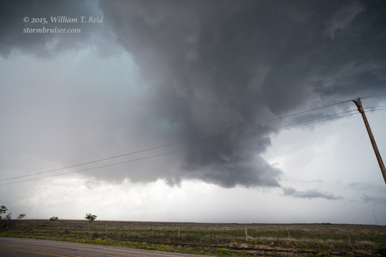
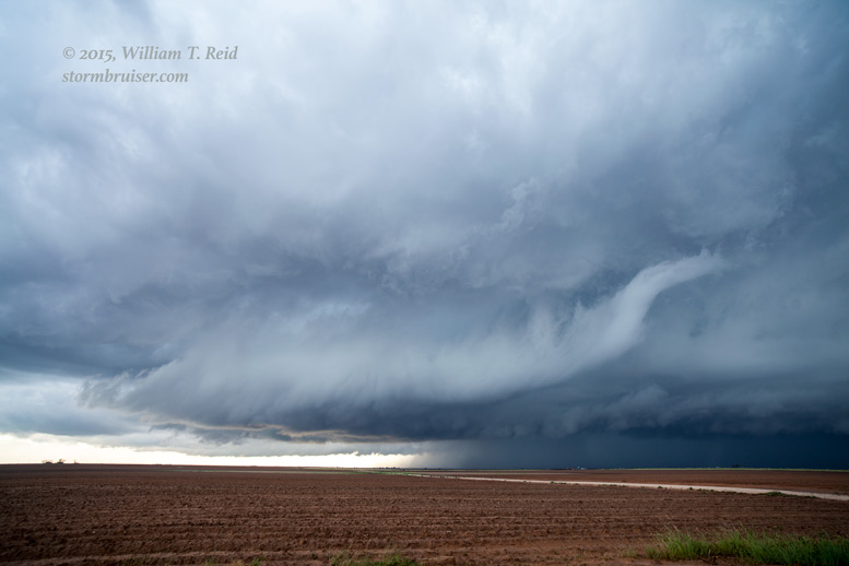
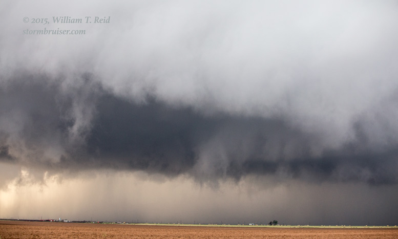
The first tornado was not terribly impressive and it lasted only a minute or two. The storm was far enough to our north so that I could get some decent structure looks with the wide-angle lens (see images above). The storm had a wicked look to it, the very low base continued to rotate strongly, and it was looking like it was in a happy spot for more tornadoes. We continued east-northeast on 846 a few miles in order to get closer to the storm base, and it was ready to put on another show.


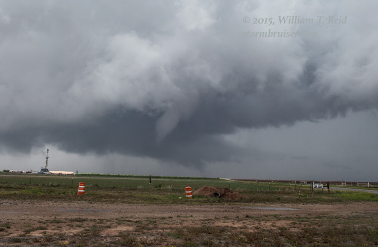
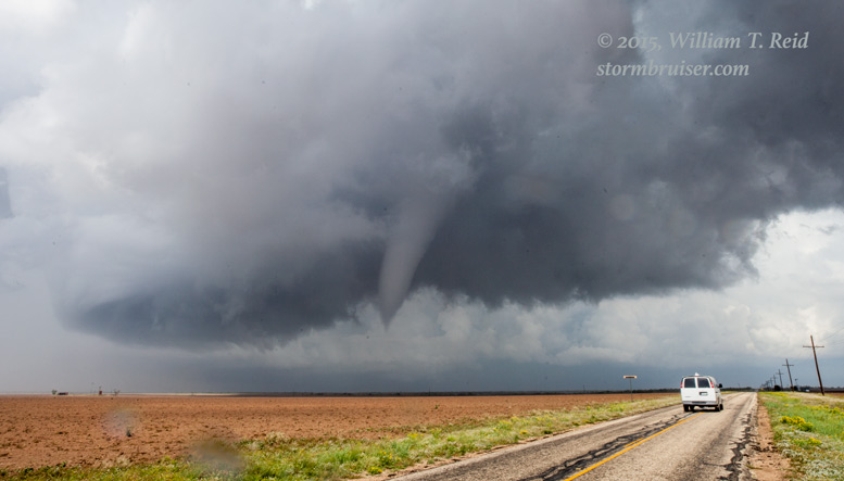
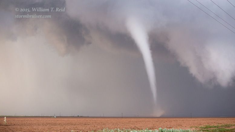
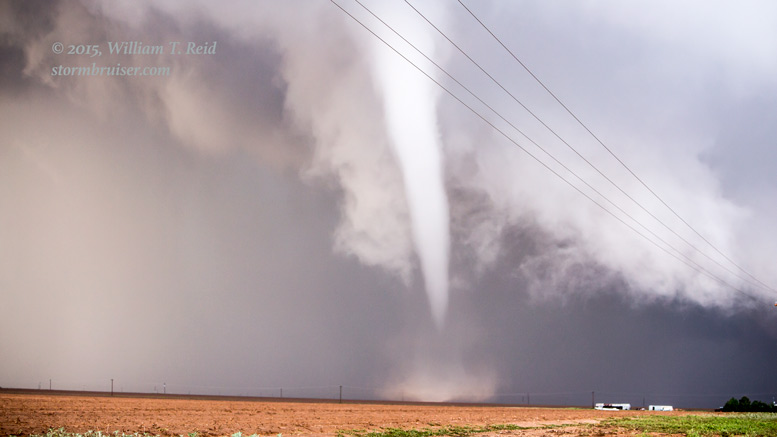
The shots above were with a wide-angle (21mm) lens, so much of the storm structure is evident. The cylinder that was carrying this tornado was rotating like crazy! The storm was moving to the east-northeast, generally parallel to our road, and it was time to catch up to it again. We continued on 846 and a fortuitous zig-zag to the north put us a little closer to the tornado. We were still in Howard County, a couple of miles southeast of a tiny place called “Luther,” so our storm would be named the “Luther” tornado.

As we raced eastward to get a close look at this tornado, it lifted and dissipated. About 20 minutes had elapsed since the first tornado had formed between Knott and Luther. The storm seemed to pick up speed towards the east-northeast, and we pressed on in that direction in case more tornadoes were to form.
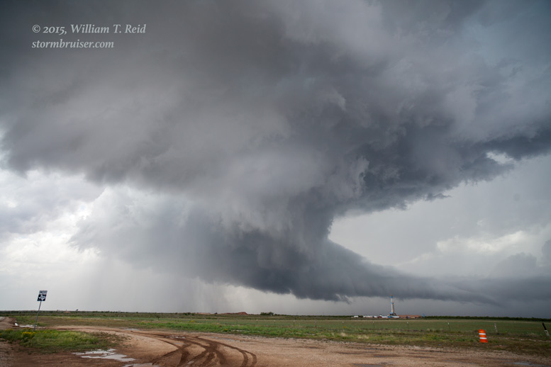
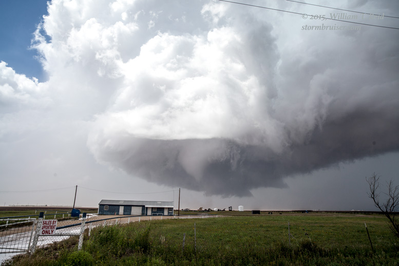
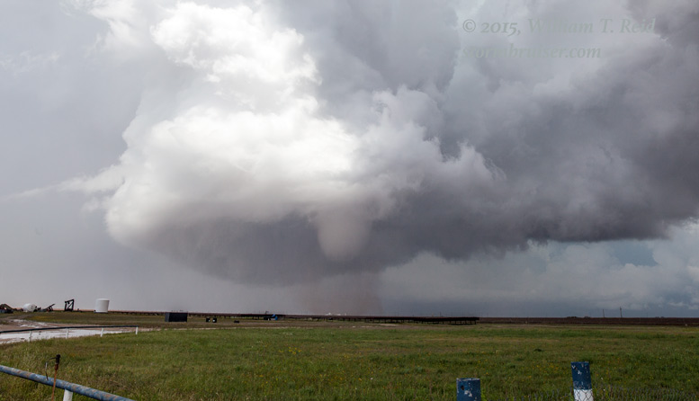
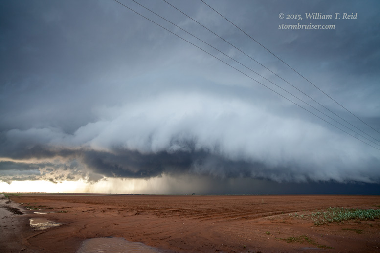
The image above was taken several minutes after the demise of the Luther tornado. The RFD cut is pronounced and the base still had a great look, but there would be no more tornadoes out of this supercell. We headed up 350 to Snyder, and stopped for a break and to watch the storm pass by. It was still quite early in the afternoon, maybe 3:30 p.m., and the question was — “What now?!” A bunch of storms were developing in our vicinity and down south towards Colorado City along I-20. Hmmm…these MIGHT be nice supercells in short order. But, I wasn’t especially keen on staying with them. I liked the environment along and near the surface boundary back to our west-northwest on the West Texas Caprock. The sun continued to shine out that way, and there was great convergence along the boundary. I was going to stick to my forecast, by golly! This early afternoon tornadic supercell near Luther almost threw me off my plan today! Incidentally, SPC had not issued a watch yet (a tornado watch was not issued until about 7 p.m.), but a mesoscale discussion at 3 p.m. CDT outlined our region of interest:
MESOSCALE DISCUSSION 0512
   NWS STORM PREDICTION CENTER NORMAN OK
   0258 PM CDT TUE MAY 05 2015

   AREAS AFFECTED...SE NM...WEST TX

   CONCERNING...SEVERE POTENTIAL...WATCH POSSIBLE

   VALID 051958Z - 052130Z

   PROBABILITY OF WATCH ISSUANCE...40 PERCENT

   SUMMARY...A SEVERE THREAT IS EXPECTED TO DEVELOP ACROSS SE NM AND
   WEST TX BY LATE THIS AFTERNOON. ISOLATED LARGE HAIL...DAMAGING WIND
   GUSTS AND PERHAPS A TORNADO WILL BE POSSIBLE. WW ISSUANCE MAY BE
   NEEDED ACROSS THE REGION.

   DISCUSSION...THE LATEST WATER VAPOR IMAGERY SHOWS A WELL-DEFINED
   DRY-SLOT OVER WEST TX FROM NEAR MIDLAND NWD TO AMARILLO. AN OUTFLOW
   BOUNDARY IS LOCATED TO THE EAST OF LUBBOCK. NORTH OF THE
   BOUNDARY...SFC TEMPS HAVE REACHED INTO THE 70S F WHERE A NARROW AXIS
   OF INSTABILITY IS LOCATED. MLCAPE IS ESTIMATED TO BE FROM 1000 TO
   1200 J/KG JUST TO THE SOUTH OF LUBBOCK ACCORDING TO MESOANALYSIS. IN
   ADDITION...A BELT OF STRONGER MID-LEVEL FLOW IS ANALYZED ACROSS SE
   NM AND WEST TX WHERE FORECAST SOUNDINGS SHOW 0-6 KM SHEAR IN THE 40
   TO 45 KT RANGE. THIS ENVIRONMENT ALONG WITH COLD TEMPS ALOFT AND
   STEEP LAPSE RATES OF 7.0 TO 7.5 C/KM SHOULD BE FAVORABLE FOR
   SUPERCELLS WITH LARGE HAIL. WIND DAMAGE WILL ALSO BE POSSIBLE AS
   CELLS INCREASE IN COVERAGE AND DOWNDRAFTS MATURE. AN ISOLATED
   TORNADO THREAT MAY ALSO DEVELOP AS CELLS INTERACT WITH THE WRN EDGE
   OF A STRENGTHENING LOW-LEVEL JET. ALTHOUGH SEVERE WEATHER IS
   ANTICIPATED ACROSS WEST TX LATE THIS AFTERNOON...UNCERTAINTY EXISTS
   CONCERNING THE NUMBER OF STORMS THAT WILL DEVELOP. FOR THAT
   REASON...THE NEED FOR A WATCH REMAINS CONDITIONAL ATTM.

   ..BROYLES/HART.. 05/05/2015
The winds were nicely backed, low-level moisture was magnificent, temperature-dew point spreads were small, and there was plenty of sunshine along and north of the boundary. We headed west towards Lamesa on U.S. 180, and then I directed Ron and Chad northward from Gail to Post, TX. Some new convection was bubbling between Post and Lubbock, and it would be prudent to get ourselves east of this new development. These updrafts were not quick to become strong, in stark contrast to the Luther storm.
At Post a critical decision was made. Strong convection was to our northwest, towards Slaton and Lubbock, and U.S. 84 would put us right up against this activity. But, a look at the road map showed a gaping hole in the road network on the east side of 84. There was a thirty-mile stretch of ZERO east options if we were to head northwest. So, I elected to head north out of Post along 207, figuring that storms might take a while longer to organize and strengthen as they drifted eastward. With any luck, the storms would be better as they neared 207.

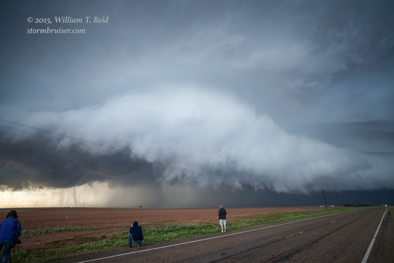
Our group drove perhaps twenty miles north of Post and stopped. A pretty updraft (above) was in front of the sun to our west and moving our way, according to plan. It was not particularly strong yet, and we killed time throwing some rocks and examining the vegetation along the lonely road. Eventually it was time to drift north as this base moved to our northwest. We came up onto the Caprock (near a little place called “Caprock”) and tried a road to the west. It quickly became unpaved and too muddy to navigate, so we backed out of that mess. We were lucky that neither of the vans got stuck in the muck. I wanted to get closer to the storm base to our northwest, which was looking better and better! But, there was nothing paved in that direction. We would have to continue waiting along 207. We stopped a few miles farther north, a little southwest of a “nothing” place called Owens, or about 10-12 miles south of Ralls. I set up two tripods and attached the cameras.

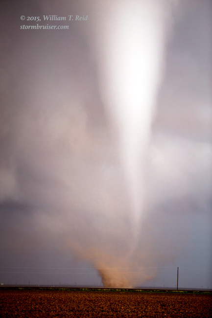
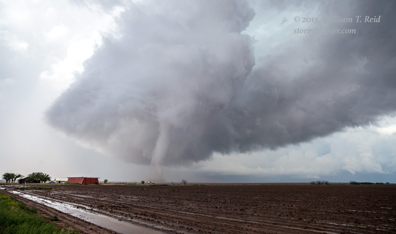
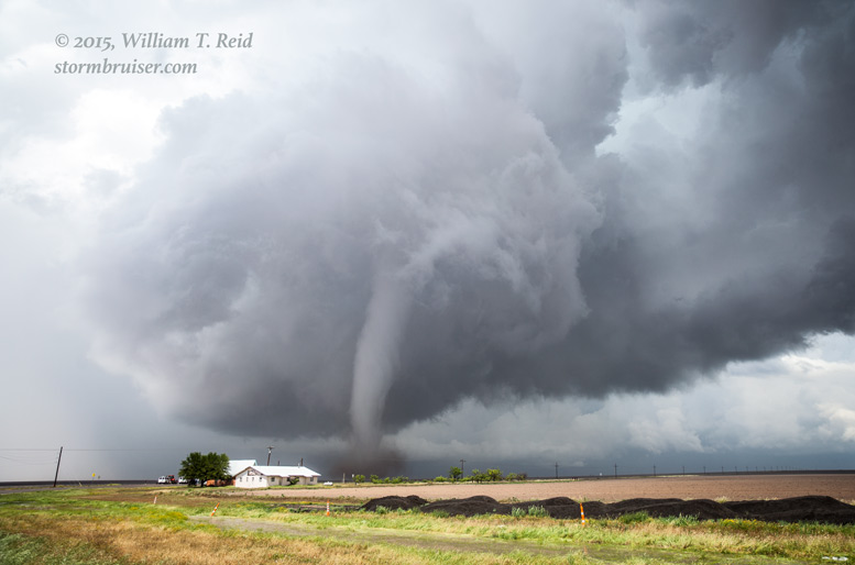
The wide-angle views above show a nicely-sculpted storm base, a very LOW storm base, and even a “pregnant”-looking black base. I remarked that tornadoes are not unusual following such features! I zoomed in some on an area with plenty of low-level motion, and it was not long before a slender, whitish-gray, elephant-trunk tornado formed. It was about 2-3 miles distant, and moving to the east.
I had a tripodded DSLR shooting video with the wide-angle, and I wanted some quick iPhone shots of this fabulous tornado. I grabbed the iPhone and aimed it north, right down 207! It looked like there were two tornados during this time, or at least one tornado and one big funnel cloud.
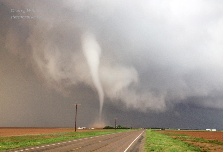
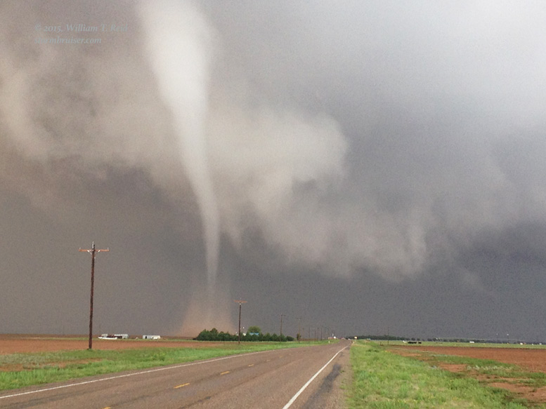


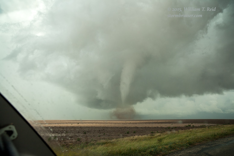
Enough with the iPhone! I took the Canon with the 70-200mm lens and shot a lot more. In the final image above, a long and slender tornado is in progress. It dissipated quickly, and the funnel cloud just to its left quickly touched down. This second tornado is the one in the pics below. The tornado continued to our northeast, and then our east! It remained perhaps two miles distant at most. We were getting rained on a bit by the time the tornado dissipated to our east, but what a show we had just been treated to!
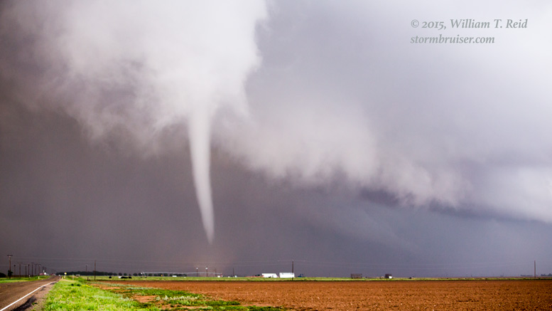

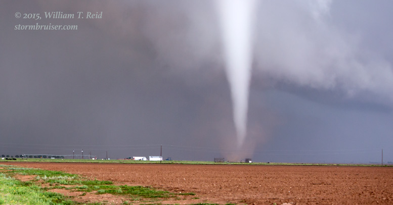


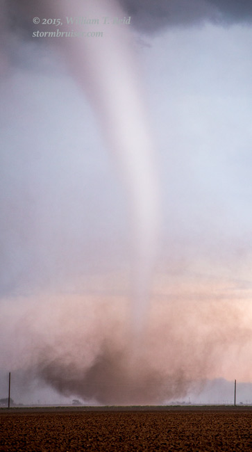

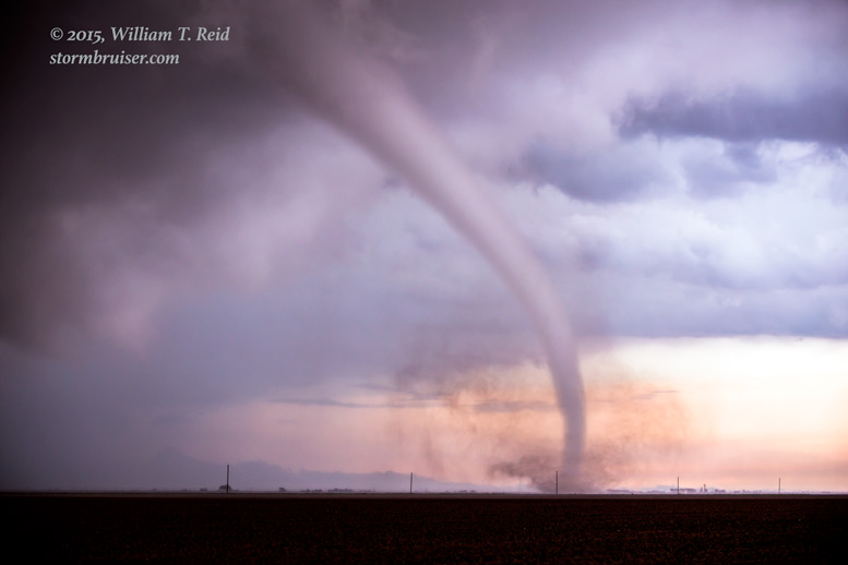

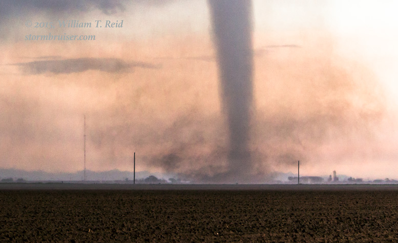
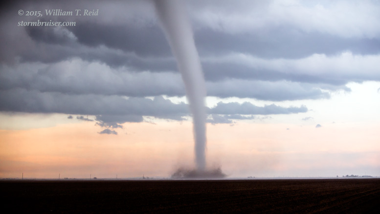
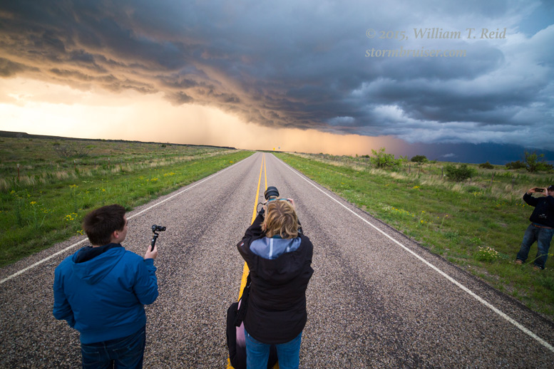
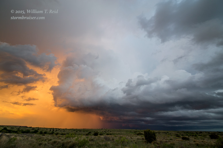
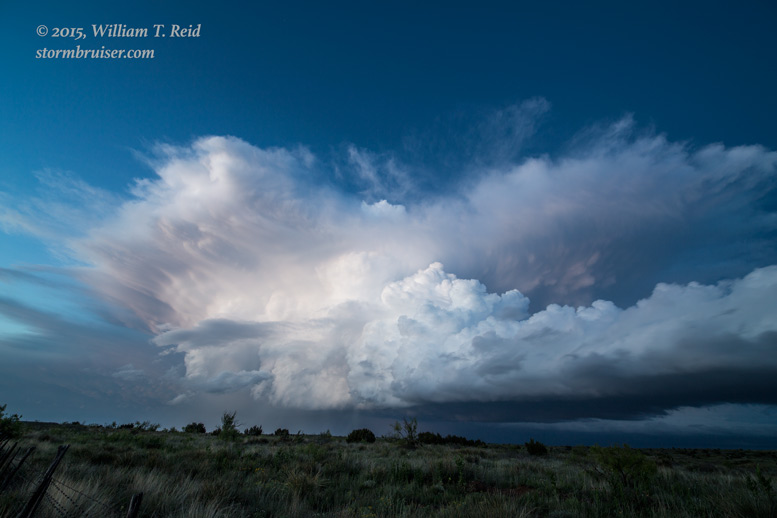
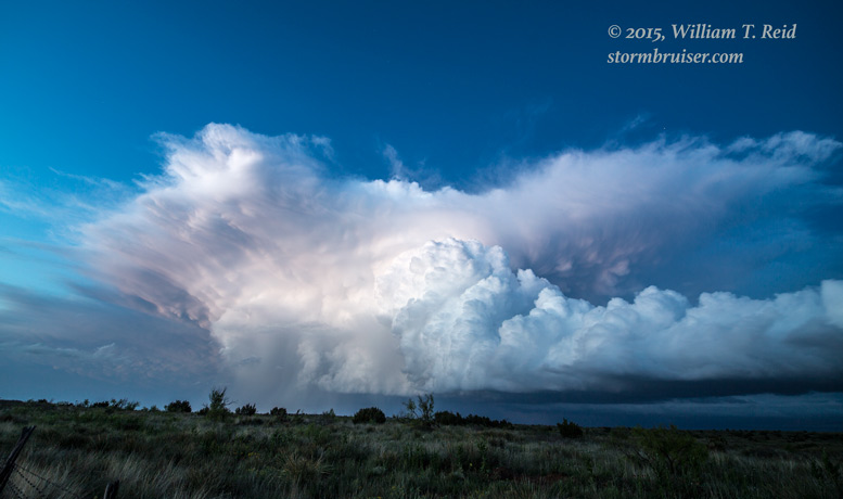
This tornadic event south of Ralls, TX, lasted for about eight minutes, and we had somehow found the perfect spot to observe the entire sequence. The parent storm was moving a tad south of due east it seemed, and the best way to stay with it was to head up north a couple of miles to FM 40 (through Owens). We motored east a little bit on 40, on the backside of the storm and in the northerly winds wrapping around the mesocyclone. Hailstones were a bit too large for comfort, though, so we had to wait it out a bit before continuing. FM 40 took us almost ten miles to the east, and then we had to head south off of the Caprock again. The storm did not appear to be a tornado-maker any longer, and so we found a nice high spot along FM 2794, west of the White River Reservoir, to enjoy a couple of nearby supercells at sunset.


WOW is about all I can say! We hit the jackpot today. I have chased since 1991 and had never had a tornado on my birthday —- which is May 6 —- but these were on May 5. This “Ralls” tornados occurred early on May 6, Zulu time…do those count as birthday tornadoes?!
These catches were especially rewarding because we were able to witness the entire life cycles of both tornadic events (Luther and Ralls) at relatively close range, outside of the vehicles for all or much of the duration, without any other folks around. Who would have thought that THAT could happen out here in West Texas in May?!
Leave a Reply
You must be logged in to post a comment.