
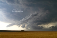
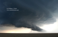
These storms in eastern Colorado displayed some supercell characteristics, replete with lowerings and dusty spinups beneath the updraft bases. The storm at sunset west of… [Read More]
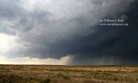
June 19, 2006 N. Lincoln County, CO high-based gusters
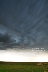
Eastern Colorado has been mired in a drought since the turn of the century, so the ground was dry on this day and low-level moisture… [Read More]
June 17, 2006 Cherokee, IA Heavy Storm
Hey, I couldn’t call it severe or a supercell, so I went with “heavy”. There was heavy rain, and some signs of organization, but not… [Read More]
June 15, 2006 Burnstad, ND Supercell

It took a while, but storms finally fired towards sunset in south-central ND and moved northeast. We were in front of a cell in Logan… [Read More]
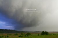
June 14, 2006 Baker, MT Severe cell

A nasty supercell was cranking near Miles City, MT and we were in front of it as it elongated and weakened somewhat between Miles City… [Read More]
June 13, 2006 Red Shirt, SD Badlands Supercell
This high-based cell provided some good-sized hailstones near Red Shirt, in extreme northwest Shannon County, SD. As the cell drifted off to the east, it… [Read More]
June 1-2, 2006 Fun in the Sun

If I recall correctly, and I usually do, there was absolutely nothing to chase on this day except ghosts. Model is on U.S. 350 northeast… [Read More]
May 30, 2006 Cimarron County, OK supercell
A decent updraft with a wall cloud developed to our southwest, in extreme southern Baca County, CO, west of 287. The storm moved east-southeast towards… [Read More]
May 29, 2006 Saline County, KS

Storms finally developed just prior to sunset, but a nice isolated supercell was not evident. I made reservations for rooms at the Days Inn in… [Read More]
May 28, 2006 Hay Springs, NE shelf cloud and squall

Storms developed south of Chadron, and we headed west and south from the Gordon vicinity. An impressive shelf cloud approached us south of Hay Springs,… [Read More]
May 25, 2006 Santa Claus, IN

Yes, Virginia, there is a Santa Claus in Indiana, and it is between Evansville, IN and Louisville, KY. And, yes, we chased all of the… [Read More]
May 20, 2006 Redbird, WY

Moisture was marginal and upper winds were unimpressive, and severe weather was not expected on the High Plains. We found a pretty cell in eastern… [Read More]
May 10 to May 18, 2006 Death Ridge Week

The Plains were high and dry for about ten consecutive days in May, 2006. We were forced into sight-seeing mode.
May 8, 2006 Kalvesta, KS supercell
This was a long day with a long drive, beginning at Sweetwater, TX. Activity went up in west-central Kansas, north of Garden City, and we… [Read More]
May 7, 2006 Martin and Midland, TX

We were near Patricia, TX again two days later. This time, a dinky LP cell croaked. We fled south to southern Midland County, where another… [Read More]