

Tour 7 for Tempest Tours began on the previous day and we chased an impressive (but fast-moving) supercell through the empty grasslands from Edgemont, SD, to Chadron, NE. Tornado prospects looked rather good a little farther north on the morning of June 21, so we headed north out of Chadron and continued towards Buffalo, SD, after lunch. SPC had an “enhanced” slight risk (and 5 percent tornado risk) covering much of western ND and northwestern SD. Storms were expected to develop in extreme eastern MT and move into the Dakotas, where favorable southeasterly flow of moist air at the surface would support a tornado threat.
On our way up through western SD from Sturgis to Buffalo, SPC issued a mesoscale discussion for western ND and much of eastern MT:
   MESOSCALE DISCUSSION 1104
   NWS STORM PREDICTION CENTER NORMAN OK
   0228 PM CDT SUN JUN 21 2015

   AREAS AFFECTED...EASTERN MONTANA AND FAR WESTERN NORTH DAKOTA

   CONCERNING...SEVERE POTENTIAL...WATCH LIKELY

   VALID 211928Z - 212130Z

   PROBABILITY OF WATCH ISSUANCE...80 PERCENT

   SUMMARY...A GRADUAL INCREASE IN THUNDERSTORM INTENSITY AND COVERAGE
   IS EXPECTED ACROSS THE DISCUSSION AREA THIS AFTERNOON.  A WW WILL BE
   ISSUED BY 21Z.

   DISCUSSION...A FEW THUNDERSTORMS HAVE DEVELOPED IN NORTHEASTERN
   MONTANA OVER THE PAST 1-2 HOURS...WITH ADDITIONAL DEVELOPMENT LIKELY
   TO OCCUR THROUGH THE LATE AFTERNOON AS INSOLATION/INCREASING
   INSTABILITY AND INCREASING FORCING FOR ASCENT CONTINUE TO OVERSPREAD
   THE DISCUSSION AREA.  CURRENT OBSERVATIONS AND MODEL FORECAST
   SOUNDINGS INDICATE THAT MARGINALLY SEVERE HAIL AND DAMAGING WIND
   GUSTS WILL BE THE MOST LIKELY THREATS WITH THESE STORMS GIVEN
   500-1000 J/KG MLCAPE...20-30 F DEWPOINT DEPRESSIONS...AND 40-50 KNOT
   DEEP LAYER SHEAR.

   LATEST HIGH RESOLUTION MODEL GUIDANCE INDICATES POTENTIAL FOR A FEW
   SUPERCELLS OVER SOUTHEASTERN MONTANA AND SOUTHWESTERN NORTH DAKOTA
   TOWARD EVENING.  A BRIEF WINDOW OF HEIGHTENED TORNADO THREAT MAY
   EXIST ACROSS THESE AREAS AS STORMS MOVE INTO AN ENVIRONMENT WITH
   HIGHER BOUNDARY LAYER MOISTURE/LOWER LCLS AND A STRENGTHENING
   LOW-LEVEL JET.  THIS THREAT WILL BE CONDITIONAL UPON STORMS
   REMAINING AT LEAST SEMI-DISCRETE DURING THAT TIME FRAME...WITH THE
   LIKELIHOOD OF STORMS CONGEALING INTO A COMPLEX INCREASING WITH
   TIME...ESPECIALLY AFTER DARK.

   A WW WILL BE ISSUED BY 21Z.

   ..COOK/CARBIN.. 06/21/2015
SPC mentioned the better environment and better tornado threat in southwestern ND. I concurred, as a nice theta-e ridge and area of low-level convergence took shape in the Baker/Buffalo/Bowman region. Plenty of cirrus clouds were bugging me a bit as we came into Buffalo. And, to add further insult, the only gas station that was open in town had a broken restroom. That was okay. We needed to be up along Highway 12 at Bowman, I figured. We made our way a little further north, and by about 3 p.m. we were in position at Bowman with empty bladders. I felt comfortable. Now all I had to do was to be patient. If a discrete storm came through this area later on today, then it should be really nice. The road network here is sketchy and sparse, though. I kept telling myself — DO NOT GET SUCKERED OUT OF POSITION! This day would probably bring the best chance for this tour group to see a tornado. I did NOT want to blow it.
We killed a little time in a field west of Bowman as a new storm quickly strengthened to our west in Montana. It was west of Baker and maybe 75 miles distant. If it held together and came through here, then we would certainly be in FAT CITY. Highway 12 was the perfect intercept route for it, and we could get close to it in the vicinity of Baker. Should I blast west and check it out? What if a new storm went up near Bowman when I got to Baker? The sky showed no real inclination to create thunderstorms here near Bowman, but things tend to change fast when you are an hour out of position. Well, quickly the look of the cell on radar was too nice. I had to head west and take a look at the Real McCoy, but I would have one eye constantly looking behind me. SPC also took note of the supercell, and issued a new MD around 4:30 p.m. MDT:
MESOSCALE DISCUSSION 1107
   NWS STORM PREDICTION CENTER NORMAN OK
   0524 PM CDT SUN JUN 21 2015

   AREAS AFFECTED...ERN MT...WRN/CNTRL ND...NWRN SD

   CONCERNING...TORNADO WATCH 324...

   VALID 212224Z - 212330Z

   THE SEVERE WEATHER THREAT FOR TORNADO WATCH 324 CONTINUES.

   SUMMARY...ALL SVR HAZARDS REMAIN POSSIBLE ACROSS TORNADO WATCH 324.
   PARTS OF NWRN SD ARE BEING MONITORED FOR A NEW WATCH AS A SUPERCELL
   OVER ERN MT APPROACHES THE AREA.

   DISCUSSION...ISOLATED STRONG TO SVR STORMS ARE ONGOING ACROSS ERN MT
   INTO N-CNTRL ND...WITH THE MOST PROMINENT BEING A RIGHT-MOVING
   SUPERCELL OVER FALLON COUNTY MT. THIS STORM IS PROGRESSING SEWD AT
   AROUND 30 KT...AND EXTRAPOLATION OF CURRENT MOTION WOULD BRING IT
   INTO NWRN SD BY AROUND 00Z. AN ASSOCIATED THREAT OF VERY LARGE
   HAIL...DMGG WIND GUSTS...AND POSSIBLY A TORNADO...WILL EXIST AS LONG
   AS CURRENT INTENSITY IS MAINTAINED AS IT MOVES INTO A FAVORABLE
   ENVIRONMENT OVER NWRN SD...AND COULD REQUIRE ISSUANCE OF A NEW WW.

   MEANWHILE...ONGOING CONVECTION ACROSS NERN MT INTO N-CNTRL ND
   APPEARS TO BE STRUGGLING TO MAINTAIN SVR INTENSITY ATTM.
   HOWEVER...RICHER MOISTURE IS ADVECTING NWD ACROSS CNTRL ND...AND THE
   ENVIRONMENT REMAINS FAVORABLE FOR AT LEAST INTERMITTENT LARGE HAIL
   AND STRONG WIND GUSTS...AND PERHAPS A TORNADO IF A DISCRETE
   SUPERCELL CAN EVOLVE.

   ..ROGERS/HART.. 06/21/2015
I stopped short of Baker by about 7 miles as the supercell to our west approached. It was high-based and looked pretty good. The bad news was that its anvil was raining on us, we were in a spot vulnerable to lightning, the storm was moving a little south of due east, and the paved road network was so bad that we would have to go back to Bowman (45 miles) in order to get in front of the updraft base. There was no way that I was going to use the unpaved roads in this area, especially early in the chase! I was still a little nervous about new convection going up a little to our east, but the anvil of this storm was shading more and more of the “prime” target area downstream. New storms along the ND/SD border appeared less likely, and this “Baker” supercell might wind up being the main show.
I think we ventured briefly into Baker to get a closer look at the base. We could have braved the hail and gone south of Baker to get close to the base, but then we would have quickly been out of position with zero paved options east (except to go back to Baker and east on 12, battling hail and rain). I elected to just go back to Bowman. Naturally, a tornado report came in for the storm south of Baker as we started east. There was a little too much precipitation blocking our view to see any tornado. If there indeed was a tornado near Baker, it was not a strong or long-lived one.
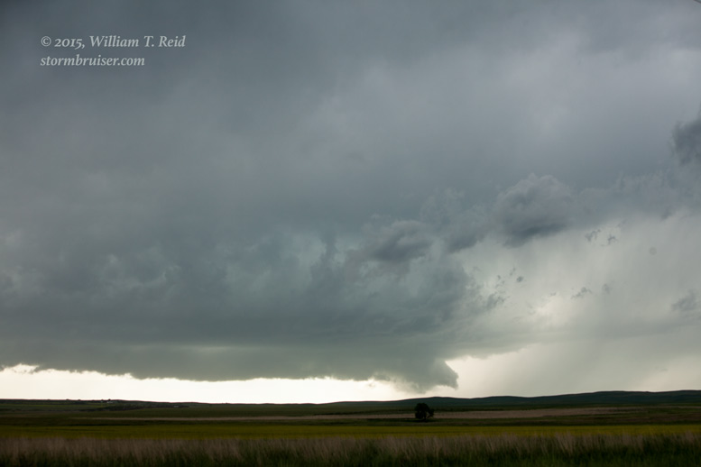
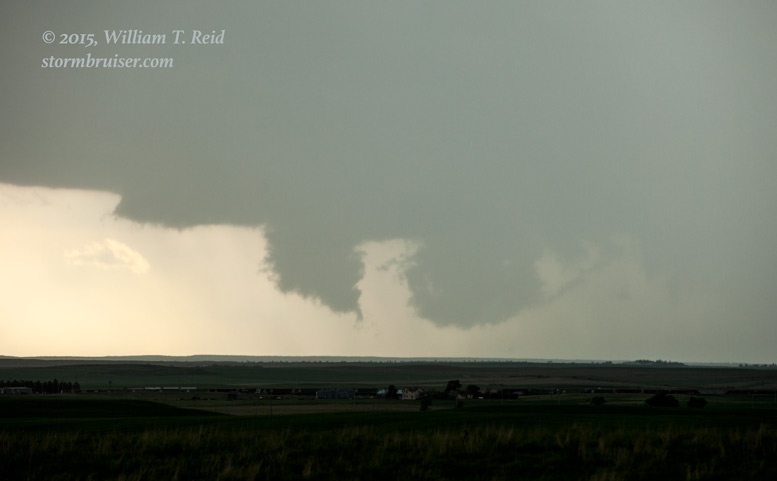
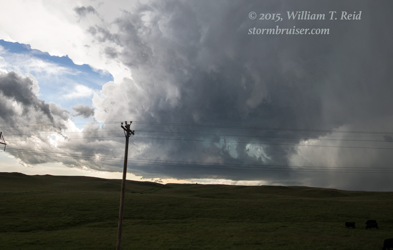
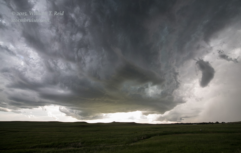
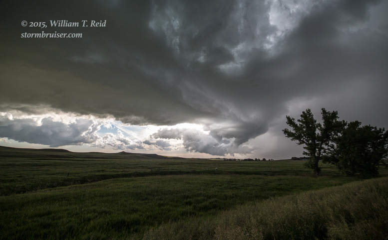
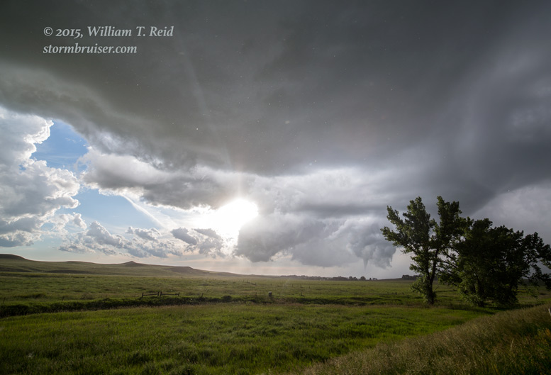
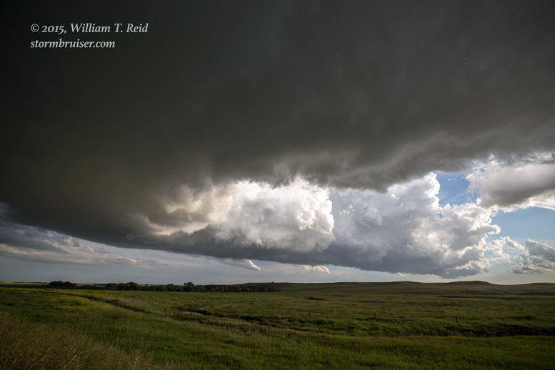
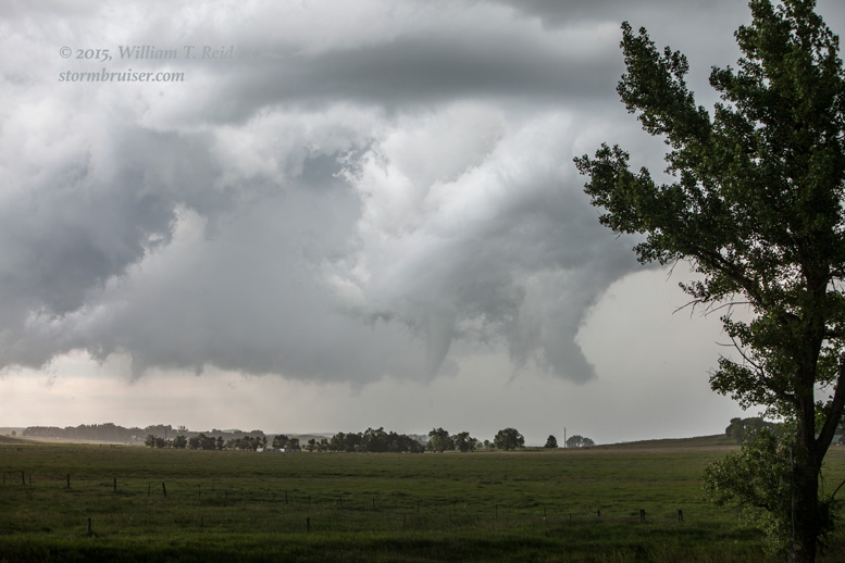
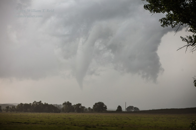
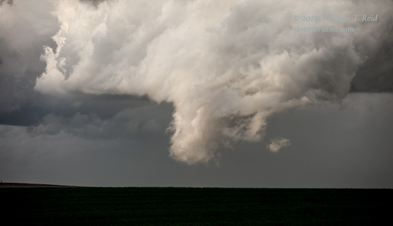
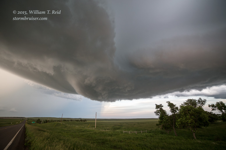
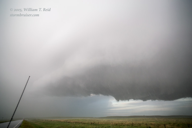
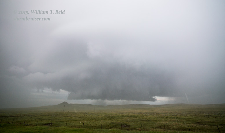
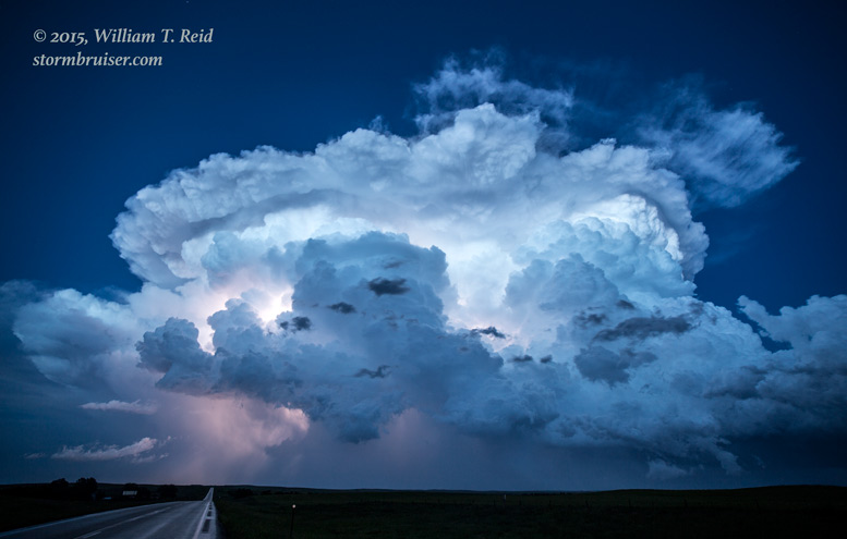
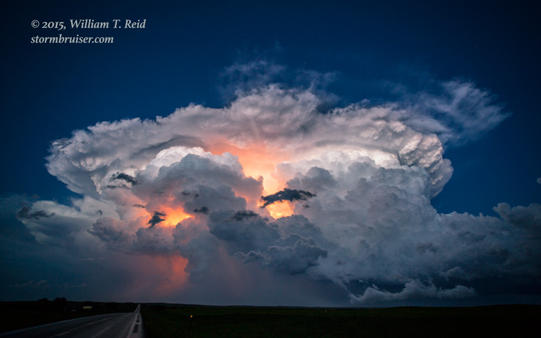
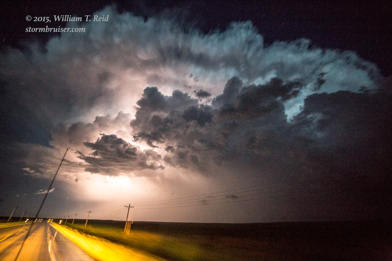
The storm was moving to the ESE at perhaps 25 mph, so it was easy to get back in front of it, as U.S. 12 also took us to the ESE. The supercell was to our southwest when we reached Bowman, and we had a decent, though somewhat distant, view of its base. It sported a wall cloud from time to time, but we were not in the right spot to see much structure (first two images below). We stopped several miles east of Bowman, and watched a new, smaller updraft quickly take shape to our northwest. This one had a rotating wall cloud (and maybe a funnel cloud) for a bit and was quite intriguing, but it was not a tornado-maker (third image below).

The key on this chase would be — TA-DA! — to be in the right place at the right time — when tornadoes were occurring! Our “Baker” supercell was now tracking close to the SD/ND border, where paved roads are absent. The next east-west paved road to my south was Highway 20 in Harding County. That was WAY too far south of this supercell, at least at this point in time. I would have to pick the right north-south road to use to cut in front of the storm when the time seemed right. I didn’t consider heading south out of Bowman, as it still seemed a little too soon. Route 12 continued to the east-southeast, so I could continue to keep an eye on the updraft base and make my move when it seemed right. Well, the time seemed right as we took off from our spot several miles east of Bowman. I passed on route 22 out of Reeder (which becomes route 79 in SD) and we turned south on route 8 out of Hettinger (which becomes route 75 in Perkins County, SD).
From Hettinger, we quickly came into South Dakota and the view of the supercell to our west got better and better. At this point the updraft base was likely a little northwest of Ludlow, SD, in extreme northeastern Harding County, and moving to the ESE.


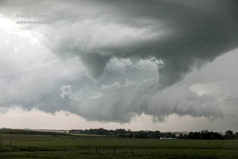
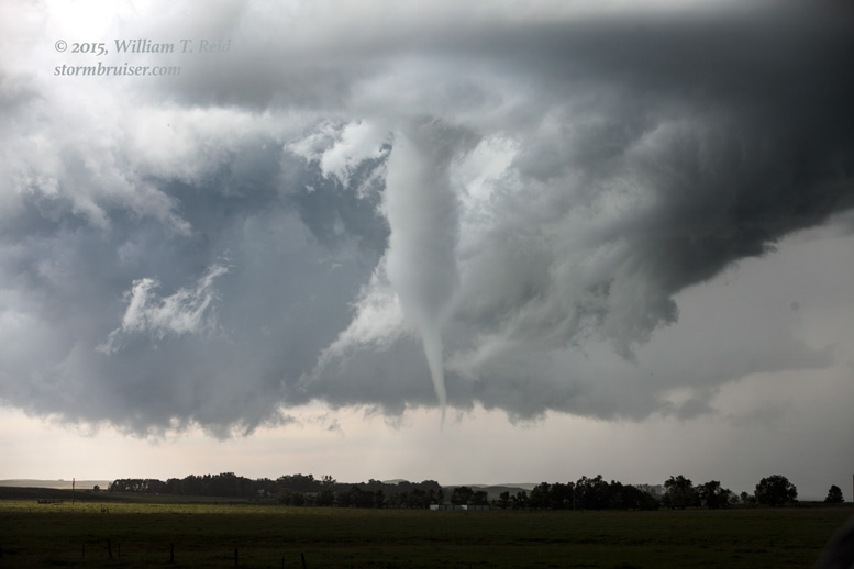
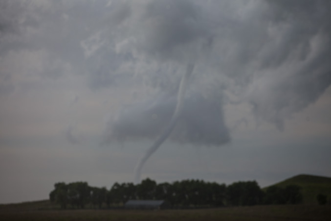
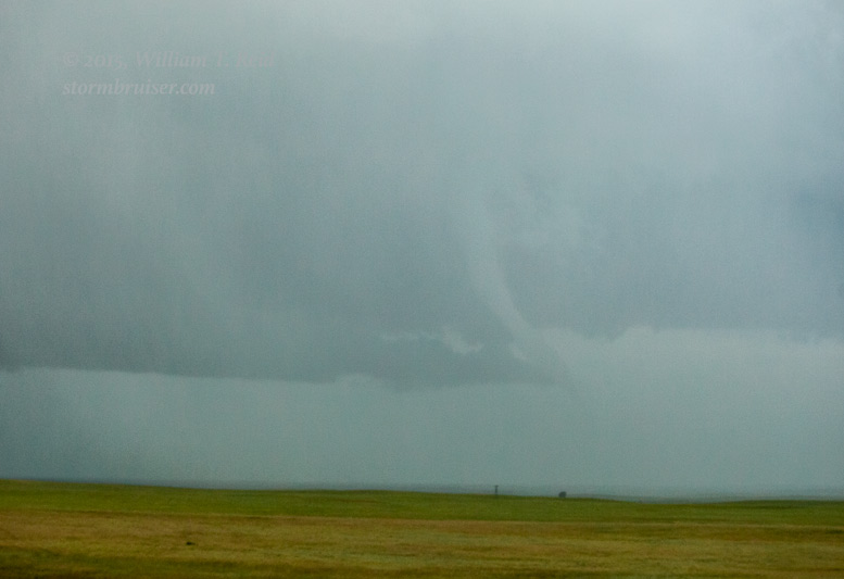
The wide-angle views above are to the west, from south of the ND/SD border by about 5-7 miles along Highway 75. There was quite a bit of hilliness, so the area beneath the storm base was generally not visible — until we came to an open area with a great look. A tornado was in progress! It was quite distant, maybe 12 to 15 miles to the west, but it was prominent and it was a fat stovepipe (seen in the third image above). I grabbed the zoom lens and got some shots as the tornado “lifted” a little:

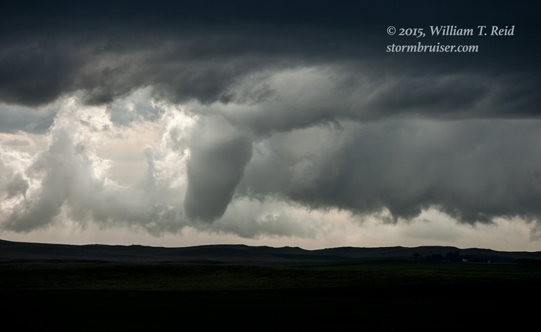
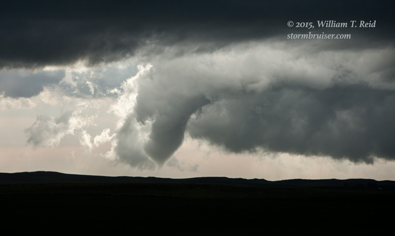
The tornado above is the “Ralph, SD” tornado. It lasted for several minutes at least and was not too far from Highway 79, east of Ludlow. The time was about 6:55 p.m. MDT.
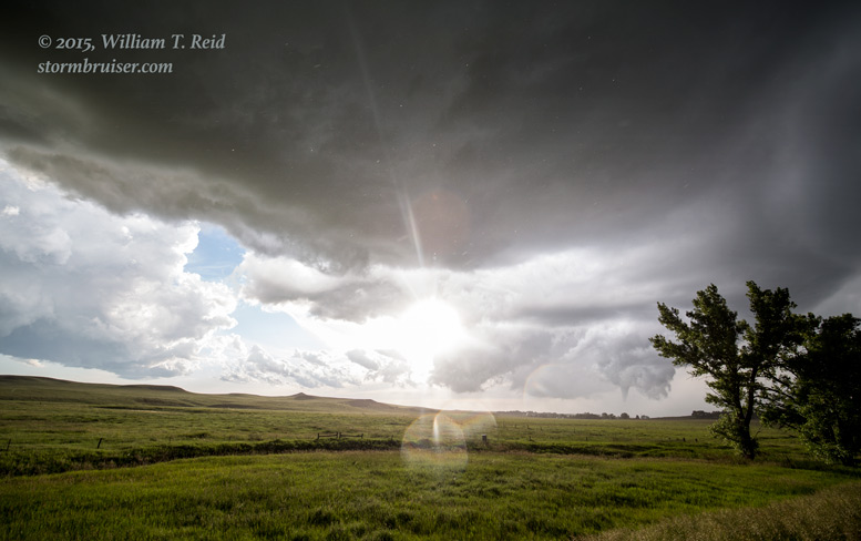
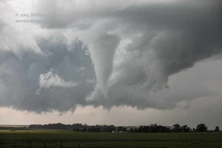
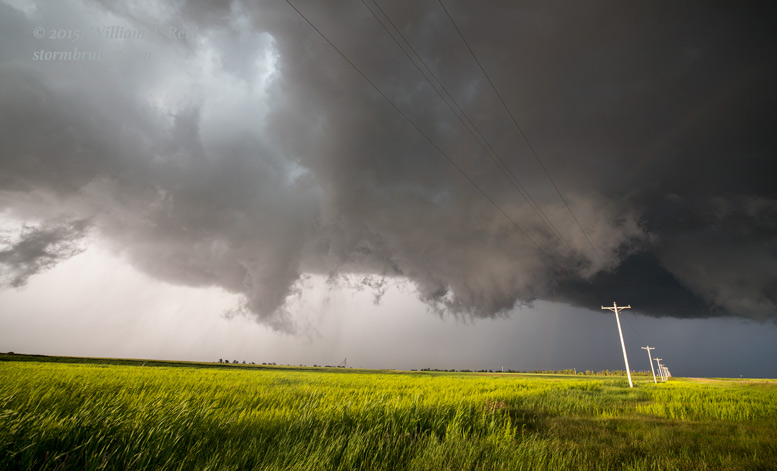
When the Ralph tornado ended we scooted another few miles to the south. We stopped along 75 a mile or so south of a little place called “Lodgepole.” This spot provided a fantastic view of the base and the updraft to our west, and it soon became a fine spot to observe the next tornado to be spawned by this “cyclic” supercell. I managed to set up both cameras on the tripods, and I prayed that we would not be chased south by hail and rain. The storm was still moving to the ESE, and we were right in its path. The updraft base featured an immense RFD cut. (The Ralph tornado was on the north side of the cut, as expected.) As the base neared our location, a new action area/low-level meso quickly took shape and the “Lodgepole” tornado developed. This was just a few miles to our northwest, and the tornado moved to the east. The first set of images below are wide-angle shots of the supercell and the “Lodgepole” circulation.


The views above are to the WNW (except for the last image, which is to the southwest), and the old, occluded Ralph meso (post-tornado) is visible behind the new Lodgepole meso. The Lodgepole tornado was from about 7:07 to 7:17 p.m. MDT. I was playing with the zoom lens for the most part during the Lodgepole tornado, trying to get quality stills and video. I managed some good shots, and then knocked the focus off a little and the last half of this tornado event was a photographic disaster. Here is a sample, with the blurry ones included for documentation purposes only, of course:


I am so embarrassed about the poor focus fiasco that I didn’t even put my name on those last two blurry images. Go ahead and use them for anything —- sell them to somebody and make money. Just promise that you won’t give me any credit.
We were quite delighted with the Lodgepole tornado! My patient and somewhat conservative chase strategy worked out nicely! The rest of the chase today would be gravy. As the Lodgepole circulation wound down another new one was ramping up just to our south! Would we get another really big show?
SPC issued another mesoscale discussion, replete with a handy surface map, at 7:30 p.m. MDT:
To get back into position on our cyclic tornadic supercell, we headed south to Highway 20 and then east towards Bison. The action area was now to our north, and it looked like another tornado was imminent.
Nothing touched down, though, and soon we were a few miles east of Bison as the action area passed overhead. We were treated to wild and crazy, and just plain UNREAL cloud motions overhead. Rear-flank downdraft winds smacked us and the tour guests were a bit unsettled. Was a tornado about to drop on top of us?! Well, I could not discern anything that looked imminent and dangerous to us, but I WAS a little nervous! We drove west a half mile just in case, and looked back at the madness just down the road to the east.

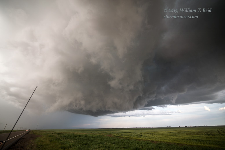
The light was fabulous and the wind was tremendous here! An organized and strongly rotating wall cloud was developing just to our east, and we were right there! The wall cloud was just south of Highway 20, perhaps five miles east of Bison. And that was a problem. The storm continued to the ESE, and the wall cloud drifted farther south of our highway and rain and hail were spreading over our highway. The next road south was ten miles to our east, near Meadow. We had a view of the wall cloud for a bit as we approached the hail core. These are wide-angle shots and the wall cloud is quite close; the time was about 7:57 p.m. MDT:

But, alas, precipitation soon obscured our view of the wall cloud, we found ourselves slowly following behind a hail core, and of course another good-sized tornado developed about 5 or 6 miles to our south that we could not see. This was around 8:07 p.m. MDT, according to the SPC log.
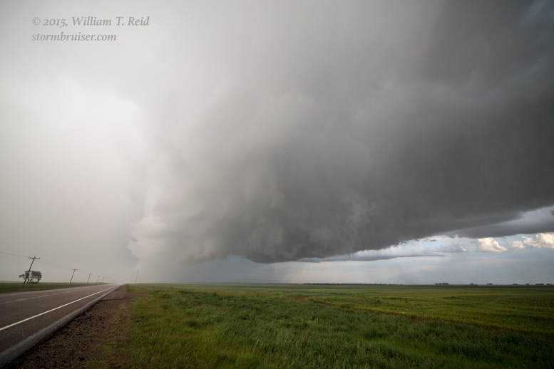
It seemed to take forever to get to Highway 73. We made our way through some non-damaging hail and emerged near the action area once more. I think this was another new meso — there was no tornado visible to the west of the highway. We went six miles south and then east again, where Highway 20 resumes. Once more, my eyes grew large as a large and strongly rotating feature took shape just to our east-southeast! Our supercell looked like it was ready to give us a grand finale, less than a mile or two away! These were taken a few miles east of 73, near a tiny spot called Coal Springs:


The rotation was tremendous, but it refused to develop any further. It was fairly close to the ground at one point and there may have been a circulation on the wet ground, but I was not able to confirm a tornado with this. Here are a couple more looks a little later:
And again we were fighting for visibility as hail and rain swept over Highway 20. We stayed with the storm for a bit and then let it move ahead, as it was past sunset now and we had no way to get back into position without getting cored. Another slender tornado emerged out of an old meso to our south as dusk approached. This was near Glad Valley:
From Glad Valley to Isabel we stopped a couple of times to photograph the backside of the supercell. Our home for the night was Mobridge.


A chase day like this one on June 21, 2015, is precisely why we storm chasers keep on chasing.
Leave a Reply
You must be logged in to post a comment.