
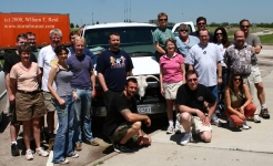
This was the first full chase day for the Tour 6 guests, and my chase team of Chuck Doswell, Rob Petitt, and Doug Raflik. On… [Read More]
June 17, 2009 York County, NE, CB and Lightning

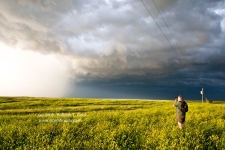
June 17th was the day of our Aurora, NE, tornado intercept. As the parent supercell continued its trek eastward from Hamilton County to York County,… [Read More]
June 11, 2009 SE CO Double Supercells

Quite the chase day this day was. With a target area of southeast CO, we were in good shape following the morning briefing in Lamar. … [Read More]
May 25, 2009 Northern TX Panhandle
Chase prospects for May 25th looked a little better than previous days, down in the TX Panhandle. We began the day in Fort Morgan, and… [Read More]
May 20, 2009 Northwest Nebraska storms
This chase day began in Rapid City, and we targeted the northwest Nebraska Panhandle. A storm went up on schedule and looked somewhat impressive, near… [Read More]
May 7, 2009 Cameron, MO supercell

Our group departed Edmond, OK, and I was thinking/hoping for thunderstorm development by late afternoon in eastern Kansas. Instability was moderate, shear was excellent, and… [Read More]
May 5, 2009 Breckenridge, TX Supercell
The only show in Texas on this day began at Breckenridge (a few counties west of Dallas), and we were there from start to finish. … [Read More]
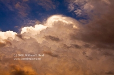
June 24, 2008 Isabel, SD Cumulonimbus and mammatus sunset
A long and somewhat disappointing day culminates in a spectacular sunset on the back side of severe storms in Corson County, SD. We started out… [Read More]
June 23, 2008 Mullen, NE supercell
After a Chinese food lunch in Alliance, we needed to drift northeast and east just a little. I was relatively comfortable sticking close to the… [Read More]
June 20, 2008 Littleton, CO Developing Cumulonimbus
Here I was, playing basketball with my nephew Eric, minding my own business, when storm clouds developed overhead. I felt obligated to document the atmospheric… [Read More]
June 19, 2008 Potter, NE small supercells
The southern Nebraska Panhandle along I-80 was the hot spot today. A strong updraft or two developed in the vicinity of Kimball, and moved east. … [Read More]
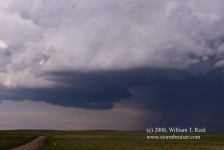
June 18, 2008 SW and SC Nebraska severe cells

A strong cell became established somewhat early in the afternoon south of Ogallala, and dove SE towards McCook. We blasted east from Wray and plunged… [Read More]
May 30, 2008 Southeast Kansas storms
Back to southeastern Kansas again! This was the final chase day for Tour 3, so it was nice that our target wasn’t too far from… [Read More]
May 27, 2008 Willow, OK Stormus Dissipatus
With hopes at a modest level at best, we scooted west into western OK as thunderstorms developed. A couple of updrafts looked good briefly, but… [Read More]
May 26, 2008 More Kansas storms

Thunder the Wonder Dog joined us for lunch in Offerle (west of Kinsley). Like the day prior, today’s storms were less than impressive. The initial… [Read More]